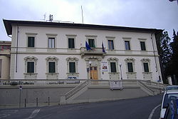
Bagno a Ripoli
Bagno a Ripoli | |
|---|---|
| Comune di Bagno a Ripoli | |
 | |
 Coat of arms | |
show Location of Bagno a Ripoli | |
 Bagno a Ripoli Location of Bagno a Ripoli in Italy | |
| Coordinates: 43°45′N 11°19′E / 43.750°N 11.317°E | |
| Country | Italy |
| Region | Tuscany |
| Metropolitan city | Florence (FI) |
| Frazioni | Antella, Candeli, le Gualchiere, Grassina, Lappeggi, Ponte a Ema, Osteria Nuova, Rimaggio, San Donato in Collina, Terzano, Vallina, Villamagna |
| Government | |
| • Mayor | Francesco Casini |
| Area | |
| • Total | 74.1 km2 (28.6 sq mi) |
| Elevation | 75 m (246 ft) |
| Population (31 December 2014)[3] | |
| • Total | 25,700 |
| • Density | 350/km2 (900/sq mi) |
| Demonym(s) | Bagnesi |
| Time zone | UTC+1 (CET) |
| • Summer (DST) | UTC+2 (CEST) |
| Postal code | 50012 |
| Dialing code | 055 |
| Patron saint | St. Peter and St. Paul |
| Saint day | June 29 |
| Website | Official website |

S. Tommaso in Baroncelli church.
Bagno a Ripoli is a comune (municipality) in the Metropolitan City of Florence in the Italian region Tuscany, located about 7 kilometres (4 mi) southeast of Florence.
The International School of Florence has its primary school campus in the comune.[4]
See also[]
References[]
- ^ "Superficie di Comuni Province e Regioni italiane al 9 ottobre 2011". Istat. Retrieved 16 March 2019.
- ^ "Popolazione Residente al 1° Gennaio 2018". Istat. Retrieved 16 March 2019.
- ^ All demographics and other statistics: Italian statistical institute Istat.
- ^ "Contact ISF Archived 2016-02-15 at the Wayback Machine." International School of Florence. Retrieved on August 17, 2015. "Junior School (Pre-School to Grade 5) Villa le Tavernule - via del Carota, 23/25 50012 Bagno a Ripoli (FI), Italy"
External links[]
| Wikimedia Commons has media related to Bagno a Ripoli. |
Categories:
- Cities and towns in Tuscany
- Municipalities of the Metropolitan City of Florence
- Metropolitan City of Florence geography stubs


