Bairiki
Bairiki | |
|---|---|
Town | |
 State House in Bairiki | |
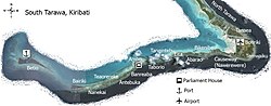 Location in South Tarawa | |
 Bairiki Location in Kiribati | |
| Coordinates: 01°19′32″N 172°59′00″E / 1.32556°N 172.98333°ECoordinates: 01°19′32″N 172°59′00″E / 1.32556°N 172.98333°E | |
| Country | |
| Island group | Gilbert Islands |
| Atoll | Tarawa |
| Area | |
| • Total | 0.460128 km2 (0.177656 sq mi) |
| Elevation | 3 m (10 ft) |
| Population (2010) | |
| • Total | 3,524 |
| • Density | 7,700/km2 (20,000/sq mi) |

Bairiki is a settlement in South Tarawa of Kiribati. The State House, the National Stadium, the High Commissions of Australia and New Zealand as well as the embassy of China, and most of the Government Ministries are based in Bairiki. Bairiki is administered by the Teinainano Urban Council or TUC. As at the 2010 Census the population of Bairiki was 3,524.
Overview[]
Bairiki was sometimes considered the capital of Kiribati because at one time both the Parliament and the Presidency (and main administrative offices) were located there. However Parliament moved to Ambo in 2000, and the various ministries are scattered throughout South Tarawa, from Betio to Bikenibeu.
Geography[]
Bairiki is an islet near the Western end of South Tarawa. It is joined to Betio by the Nippon Causeway, which opened in 1989, and is also joined to Naanekai by a causeway, forming part of a continuous road which links South Tarawa from Betio in the West to Bonriki International Airport in the East.
Bairiki is a small islet, with a land area of less than half a square km.[1] Much of the land is occupied by the Government itself, including the Bairiki National Stadium and the main offices of many of the Government ministries, and by foreign High Commissions with their associated residences. The village community of Bairiki lives in very crowded conditions, and rapid population growth is causing significant problems.
Education[]
This section needs expansion. You can help by . (July 2018) |
King George V School, a secondary school for boys, opened in Bairiki in 1922. It later moved to Abemama.[2]
Transport[]
The city has road connections to Betio and
| Census | 1978[3] | 2005[4] | 2010[5] |
|---|---|---|---|
| Bairiki | 1,956 | 2,766 | 3,524 |
See also[]
References[]
- ^ "Kiribati Census 2010 Volume 1" (PDF). Statistics Office, Ministry of Finance and Economic Development, Government of Kiribati. Archived from the original (PDF) on 2013-09-30.
- ^ Talu, Alaima. "Towards Quality in Education" (Chapter 21, in Part IV: Social Issues). In: Van Trease, Howard (editor). Atoll Politics: The Republic of Kiribati. University of Canterbury MacMillan Brown Centre for Pacific Studies and University of the South Pacific, 1993. ISBN 095833000X, 9780958330008. p. 241
- ^ Report of the 1978 Census of population and housing. Republic of Kiribati 1980, Vol. 1, S. 6–7
- ^ Kiribati 2005 census of population and housing.
- ^ "Kiribati Census Report 2010 Volume 1" (PDF). National Statistics Office, Ministry of Finance and Economic Development, Government of Kiribati. Archived from the original (PDF) on 30 September 2013. Retrieved 17 March 2013.
External links[]

| show Authority control |
|---|
- South Tarawa
- Populated places in Kiribati
- Capitals in Oceania