Outline of Kiribati
Coordinates: 1°52′25.2″N 157°25′32.8″W / 1.873667°N 157.425778°W

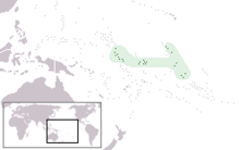
Location of Kiribati


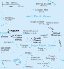
An enlargeable map of the Republic of Kiribati
The following outline is provided as an overview of and topical guide to Kiribati:
Kiribati – sovereign island nation located in the central equatorial Pacific Ocean.[1]
General reference[]
- Pronunciation: /kiː.ɹɨˈbæs/[2]
- Common English country name: Kiribati
- Official English country name: The Republic of Kiribati
- Common endonym(s):
- Official endonym(s):
- Adjectival(s): I-Kiribati
- Demonym(s): I-Kiribati
- Etymology: Name of Kiribati
- ISO country codes: KI, KIR, 296
- ISO region codes: See ISO 3166-2:KI
- Internet country code top-level domain: .ki
Geography of Kiribati[]
- Kiribati is: an island country
- Location:
- Southern Hemisphere and Eastern Hemisphere
- Pacific Ocean
- South Pacific
- Time zones:
- Extreme points of Kiribati
- High: unnamed location on Banaba 81 m (266 ft)
- Low: Pacific Ocean 0 m
- Land boundaries: none
- Coastline: Pacific Ocean 1,143 km
- : 110,000 (2015) - 188th most populous country
- : 726 km2
- Atlas of Kiribati
Environment of Kiribati[]

- Climate of Kiribati
-
- Wildlife of Kiribati
Natural geographic features of Kiribati[]
- Islands of Kiribati
- Lakes of Kiribati
- Rivers of Kiribati
- World Heritage Sites in Kiribati: Phoenix Islands Protected Area
Regions of Kiribati[]
Ecoregions of Kiribati[]
Administrative divisions of Kiribati[]
None
Municipalities of Kiribati[]
- Capital of Kiribati: South Tarawa
- Cities of Kiribati
Demography of Kiribati[]
Government and politics of Kiribati[]
- Form of government: unitary parliamentary representative democratic republic
- Capital of Kiribati: South Tarawa
- Elections in Kiribati
- Political parties in Kiribati
Branches of the government of Kiribati[]
Government of Kiribati
Executive branch of the government of Kiribati[]
Legislative branch of the government of Kiribati[]
Judicial branch of the government of Kiribati[]
- (higher court)
Foreign relations of Kiribati[]
- Diplomatic missions in Kiribati
- Diplomatic missions of Kiribati
International organization membership[]
The Republic of Kiribati is a member of:[1]
Law and order in Kiribati[]
- Constitution of Kiribati
- Human rights in Kiribati
- LGBT rights in Kiribati
- Freedom of religion in Kiribati
- Law enforcement in Kiribati
Military of Kiribati[]
Military of Kiribati There is no military in Kiribati.[3]
Local government in Kiribati[]
History of Kiribati[]
Culture of Kiribati[]
- Dance in Kiribati
- Languages of Kiribati
- Media in Kiribati
- People of Kiribati
- Public holidays in Kiribati
- Religion in Kiribati
- Christianity in Kiribati
- Hinduism in Kiribati
- Islam in Kiribati
- World Heritage Sites in Kiribati:
Art in Kiribati[]
- Dance in Kiribati
- Music of Kiribati
- Television in Kiribati
Sports in Kiribati[]
Economy and infrastructure of Kiribati[]
- Economic rank, by nominal GDP (2007): 189th (one hundred and eighty ninth)
-
- Communications in Kiribati
- Internet in Kiribati
- Currency of Kiribati: Dollar
- ISO 4217: AUD
-
- Transport in Kiribati
Education in Kiribati[]
Infrastructure of Kiribati[]
- Transportation in Kiribati
See also[]
| English language edition of Wikipedia, the free encyclopedia |
- Gilbertese language
- List of international rankings
- List of Kiribati-related topics
- Member state of the Commonwealth of Nations
- Member state of the United Nations
- Outline of geography
- Outline of Oceania
References[]
- ^ Jump up to: a b "Kiribati". The World Factbook. United States Central Intelligence Agency. July 2, 2009. Retrieved July 23, 2009.
- ^ "Kiribati", Oxford Advanced Learner's Dictionary
- ^ "Kiribati", CIA World Factbook
External links[]
Kiribatiat Wikipedia's sister projects
 Definitions from Wiktionary
 Media from Wikimedia Commons
 News from Wikinews
 Quotations from Wikiquote
 Texts from Wikisource
 Textbooks from Wikibooks
 Resources from Wikiversity
- Parliament of Kiribati
- Encyclopædia Britannica, Kiribati
- Phoenix Islands Protected Area Archived 2019-12-03 at the Wayback Machine
- Outline of Kiribati at Curlie
 Kiribati travel guide from Wikivoyage
Categories:
- Outlines of countries
- Kiribati
- Kiribati-related lists