Balaclava, Victoria
hideThis article has multiple issues. Please help or discuss these issues on the talk page. (Learn how and when to remove these template messages)
|
| Balaclava Melbourne, Victoria | |||||||||||||||
|---|---|---|---|---|---|---|---|---|---|---|---|---|---|---|---|
 Carlisle Street | |||||||||||||||
 Balaclava | |||||||||||||||
| Coordinates | 37°52′23″S 144°59′35″E / 37.873°S 144.993°ECoordinates: 37°52′23″S 144°59′35″E / 37.873°S 144.993°E | ||||||||||||||
| Population | 5,396 (2016 census)[1] | ||||||||||||||
| • Density | 6,700/km2 (17,500/sq mi) | ||||||||||||||
| Postcode(s) | 3183 | ||||||||||||||
| Area | 0.8 km2 (0.3 sq mi) | ||||||||||||||
| Location | 7 km (4 mi) from Melbourne | ||||||||||||||
| LGA(s) | City of Port Phillip | ||||||||||||||
| State electorate(s) | Caulfield | ||||||||||||||
| Federal Division(s) | Macnamara | ||||||||||||||
| |||||||||||||||

Balaclava is an inner suburb of Melbourne, Australia, 7 km south from Melbourne's Central Business District. Its local government area is the City of Port Phillip. At the 2016 Census, Balaclava had a population of 5,396.[1]
Balaclava is located in the south-east of the city, in the St Kilda East area and is bounded by Inkerman Street to the north, Chapel Street to the west, Hotham Street to the east and Oak Grove and Los Angeles Court to the south. In terms of its cadastral division, Balaclava is in the parish of Prahran, within the County of Bourke
The suburb was named after the Battle of Balaclava that took place on 25 October 1854, during the Crimean War.
Well known television celebrity Graham Kennedy spent part of his childhood in the Balaclava area. After his death, the local council placed a commemorative plaque on the house in which he lived.
Balaclava is home to much of Melbourne's Orthodox Jewish Community, consisting of both Hasidim and non-Hasidim (Mitnagdim or Yeshivish) Jews. Within its confines are a number of kosher restaurants and shops that cater to the local and broader Melbourne Haredi communities.
Streets[]
Many streets in Balaclava and its vicinity are named after Crimean War battles; e.g., the Battle of Balaclava (Balaclava Road), the Battle of Inkerman (Inkerman Road), the Siege of Sevastopol (Sebastopol Street), the Battle of the Alma River (Alma Road), the Battle of the Great Redan (Redan Street) and the Battle of Malakoff (Malakoff Street).
One street, Crimea Street, is named after the war itself.
Other streets in the district are named after people connected with the Crimean War; e.g., Lord Raglan (Raglan Street), Lord Cardigan (Cardigan Street), Florence Nightingale (Nightingale Street), François Certain Canrobert (Canrobert Street) and Lord Lucan (Lucan Street).
Local landmarks[]
- Caulfield Campus of Caulfield Grammar School – the suburb's largest school.
- St Kilda Primary School – a public primary school originally opened in 1875.[2]
- St Colman's School Hall, Carlisle Street (1938–39) – designed to complement the church next door (now CBC St Kilda's Yr 9 Campus, previously King David School's Carlisle campus and St Kevin's College Waterford Campus).

Lady of St Kilda mural, Carlisle Street
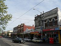
Main shopping strip, Carlisle Street

St Colman's School Hall, Carlisle Street


Residential architecture[]

Late 1870s terrace housing in Inkerman Street
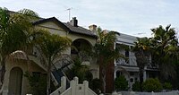
Combinations of Victorian terraces and late Edwardian duplexes and a variety of subtropical palms


Places of worship[]
There are many churches in Balaclava, with many of the modern places of worship serving the Jewish Faith, but many of the older buildings have at some point served various Christian religions.
Many of the church buildings in Balaclava are historic and heritage registered and form various religious precincts. Historic church buildings include:
- St Colman's Catholic Church, Carlisle Street (1913, designed by Watts' Sons).
- St George's Presbyterian Church, Chapel Street. Built in 1877–80 to the design of Albert Purchas. Listed on the Victorian Heritage Register.
- Holy Trinity Anglican Church, Chapel Street. Designed by Joseph Reed and built in 1878, the building is Victorian Heritage listed.[3]
- Former Balaclava Corps Hall.
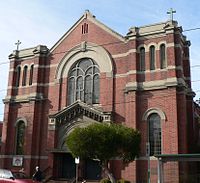
St Colman's Catholic Church, Carlisle Street. Twin decorative towers were removed in the 1960s.

Transport[]
Balaclava is served by several forms of public transport.
The main railway station, Balaclava, is on the Sandringham railway line.[4]
Tram routes 3[5] and 16[6] operate along Carlisle Street and route 78[7] operates along Chapel Street.
Bus routes 216 and 219 operate along Hotham Street. The importance of these routes has declined in recent years and are subject to change in 2017.
A taxi rank operates on Carlisle Street, outside the Coles Supermarket.
Notable residents[]
See also[]
- City of St Kilda – A former local government area of which Balaclava was a part.
References[]
- ^ Jump up to: a b Australian Bureau of Statistics (27 June 2017). "Balaclave (Vic) (State Suburb)". 2016 Census QuickStats. Retrieved 13 April 2018.

- ^ "History - St Kilda Primary School".
- ^ "Holy Trinity Balaclava and Elwood". holytrinitybalaclavaandelwood.com.au. Retrieved 31 December 2019.
- ^ Victoria, Public Transport. "Sandringham Line". Public Transport Victoria. Retrieved 19 November 2020.
- ^ "Route 3 - Yarra Trams". yarratrams.com.au. Retrieved 19 November 2020.
- ^ "Route 16 - Yarra Trams". yarratrams.com.au. Retrieved 19 November 2020.
- ^ "Route 78 - Yarra Trams". yarratrams.com.au. Retrieved 19 November 2020.
External links[]
- Monash University – Australian Places
- City of Port Phillip Heritage Register
- Balaclava/East St Kilda Council overview
| show Authority control |
|---|
- Suburbs of Melbourne
- Orthodox Jewish communities