Baluchistan Agency
| Balochistan Agency | |||||||
|---|---|---|---|---|---|---|---|
| Agency of British India (1877–1947) Colony of the United Kingdom (1947) | |||||||
| 1877–1947 | |||||||
 Baluchistan Agency | |||||||
| Area | |||||||
• 1941 | 347,064[1] km2 (134,002 sq mi) | ||||||
| Population | |||||||
• 1941 | 857,835 [1] | ||||||
| History | |||||||
| History | |||||||
• Signature of the Treaty of Mastung by the Khan of Kalat and the Baloch Sardars | 1877 | ||||||
• Balochistan Made Separate British Colony (British Balochistan) | 1947 | ||||||
• Independence of Pakistan | 1947 | ||||||
| |||||||
| "A collection of treaties, engagements, and sunnuds relating to India and neighbouring countries" | |||||||
The Baluchistan Agency (or Balochistan or Baloochistan or British Balochistan) was one of the colonial agencies of British India. It was located in the present-day Pakistani Balochistan province.[2]
| Princely state |
|---|
| Individual residencies |
|
| Agencies |
|
| Lists |
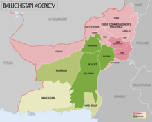
Geography[]
The territories of the agency covered an area of 208,262 km2 (44,345 square miles)[dubious ] and included areas which had been acquired by lease or otherwise brought under direct British control, as well as the princely states.
History[]
This political agency was established in 1877, following the 1876 treaty signed in Mastung by Baloch leaders by means of which they accepted the mediation of the British authorities in their disputes.[3]
Colonel Sir Robert Groves Sandeman introduced an innovative system of tribal pacification in Balochistan that was in effect from 1877 to 1947. However the Government of India generally opposed his Methods and refused to allow it to operate in India's North West Frontier. Historians have long debated its scope and effectiveness in the peaceful spread of Imperial influence.[4]
Demographics[]
| Religion | Population (1911)[5] | Percentage (1911) | Population (1941)[1] | Percentage (1941) |
|---|---|---|---|---|
| Islam |
782,648 | 93.76% | 785,181 | 91.53% |
| Hinduism |
38,326 | 4.59% | 54,394 | 6.34% |
| Sikhism |
8,390 | 1.01% | 12,044 | 1.4% |
| Christianity |
5,085 | 0.61% | 6,056 | 0.71% |
| Zoroastrianism | 170 | 0.02% | N/A | N/A |
| Judaism | 57 | 0.01% | N/A | N/A |
| Buddhism | 16 | 0% | N/A | N/A |
| Jainism | 10 | 0% | N/A | N/A |
| Others | 1 | 0% | 160 | 0.02% |
| Total Population | 834,703 | 100% | 857,835 | 100% |
Princely states[]
The Baluchistan Agency consisted of three princely states:
- Kalat khanate, the premier state and only salute state (Hereditary salute of 19-guns; titles Wali, Khan; from 1739 Wali, Begler Begi, Khan), including its Jhalawan, Kacchi and Sarawan administrative divisions
- while Makran (title Nazem, later Nawwab) is quoted as either another division, a vassal state or autonomous
- and Kalat's two feudatory states :
The Government of India maintained its relations with the states through its political agent in Kalat. The first agent in Balochistan was Robert Groves Sandeman (1835-1892), Knight Commander of the Order of the Star of India, who was appointed by Lord Lytton, the Viceroy of India.[3]
Administrative structure[]

In addition to the princely states, the north of the agency was administered as the Chief Commissioner's Province. This consisted of the following districts:
- Chagai
- Quetta-Pishin (including Quetta)
- Jhatpat
- Loralai
- Sibi (including Bugti and Marri tribal areas)
- Zhob
See also[]
- History of Balochistan
- List of Indian Princely States
- Treaty of Kalat
References[]
- ^ a b c "CENSUS OF INDIA, 1941 VOLUME XIV BALUCHISTAN". Retrieved 23 September 2021.
- ^ Administration report of the Balochistan Agency for 1888–89: selections from the records of the Government of India, Foreign Department. 104pgs.
- ^ a b "Balochistan Archives - Records of the Agent to the Governor General in Balochistan". Archived from the original on 2015-07-09. Retrieved 2015-07-31.
- ^ Christian Tripodi, "'Good for one but not the other': The 'Sandeman System' of Pacification as Applied to Baluchistan and the North-West Frontier, 1877-1947." Journal of Military History 73#3 (2009): 767-802. online
- ^ "CENSUS OF INDIA, 1911 VOLUME IV BALUCHISTAN" (PDF). Retrieved 23 September 2021.
- ^ The Imperial Gazetteer of India (1907-1909)
Coordinates: 29°01′33″N 66°35′24″E / 29.02583°N 66.59000°E

This Balochistan location article is a stub. You can help Wikipedia by . |
- States and territories established in 1877
- States and territories disestablished in 1947
- Agencies of British India
- Khanate of Kalat
- 1877 establishments in India
- Balochistan (Pakistan) geography stubs