Bang Pakong River
| Bang Pakong River Jolo River | |
|---|---|
 | |
 Bang Pakong River highlighted in red | |
| Native name | แม่น้ำบางปะกง (Thai) |
| Location | |
| Country | Thailand |
| Physical characteristics | |
| Source | |
| • location | Confluence of Phra Prong River and Hanuman River |
| Mouth | |
• location | Bang Pakong District |
• elevation | 0 m (0 ft) |
| Length | 231 km (144 mi) |
| Basin size | 17,000 km2 (6,600 sq mi) |
| Basin features | |
| River system | Bang Pakong |
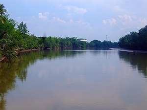
The Bang Pakong (Thai: แม่น้ำบางปะกง, RTGS: Maenam Bang Pakong, pronounced [mɛ̂ː.náːm bāːŋ pā.kōŋ]) is a river in east Thailand. The river originates at the confluence of the Phra Prong River and the Hanuman River near Kabin Buri, Prachinburi Province. It empties after 231 kilometres[1] into the Gulf of Thailand at the northeastern tip of the Bay of Bangkok. The watershed of the Bang Pakong is about 17,000 square kilometres (6,600 sq mi). The river powers a power station near its mouth, near Highway 7.
To protect the Irrawaddy dolphins, fishermen on the Bang Pakong River have been persuaded by authorities to stop shrimping and 30 to 40 fishing boats have been modified so they can offer dolphin sightseeing tours.[2]
Dvaravati settlements include Muang Phra Rot, Dong Si Maha Pht, Dong Lakhon, and Ban Khu Muang. Dvaravati coins have been found at U-Tapao.[3]:302, 309
Toponymy[]
Its name "Bang Pakong" is believed to be distorted from the word "Bang Mangkong" (บางมังกง), refers to "place of Mangkong", for "Mangong" is Thai word meaning long whiskers catfish (Mystus gulio), a species of brackish water catfish that used to be found in this river.[4]
This name has been mentioned in Sunthorn Phu's poem Nirat Mueang Klaeng (นิราศเมืองแกลง, "journey to Klaeng") since early Rattanakosin period.[4]
Anyway, it is also proposed that the name may have a Khmer origin as a mixture of "Bang" in Thai, meaning "estuary community", and the word "Bongkong" (បង្កង) in Khmer meaning "prawn". Overall, it means "the river full of prawn".[5]
Moreover, this river is known locally in Chachoengsao Province as Jolo River (แม่น้ำโจ้โล้, Chinese: 尖吻河, pinyin: jiān wěn hé), from the Teochew name for the barramundi (Lates calcarifer) because of the abundance of this species of fish.[6] Famous temples along the river include and Wat Sothonwararam.
Tributaries[]
References[]
| Wikimedia Commons has media related to Bang Pakong River. |
- ^ "Moves to enlarge Bang Pakong River upset locals". Bangkok Post. 2019-05-09. Retrieved 2019-05-10.
- ^ Svasti, Pichaya (2007-03-24). "The Irrawaddy dolphin". Bangkok Post. Reprinted by ASEAN Biodiversity. Retrieved 2008-12-30.
- ^ Higham, C., 2014, Early Mainland Southeast Asia. Bangkok: River Books Co., Ltd., ISBN 9786167339443
- ^ Jump up to: a b "ข้อมูลตำบลบางปะกง อำเภอบางปะกง ฉะเชิงเทรา" [Information of Bang Pakong Subdistrict, Bang Pakong District, Chachoengsao]. ThaiTambon (in Thai).
- ^ "บางปะกง แม่น้ำกุ้งชุม กลายคําจากภาษาเขมร?" [Bang Pakong the river full of prawn distorted from the Khmer?]. Arts & Culture Magazine (in Thai). 2020-12-31. Retrieved 2021-01-18.
- ^ "วัดปากน้ำโจ้โล้" [Wat Pak Nam Jolo]. Ceediz.com (in Thai).
| Authority control |
|
|---|
Coordinates: 13°26′50″N 100°56′53″E / 13.4471°N 100.948°E

- Rivers of Thailand
- Bay of Bangkok
- Thailand river stubs