Barcombe
| Barcombe | |
|---|---|
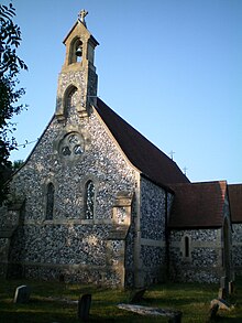
 Barcombe Anglican parish church | |
 Barcombe Location within East Sussex | |
| Area | 17.8 km2 (6.9 sq mi) [1] |
| Population | 1,473 (Parish-2011)[2] |
| • Density | 211/sq mi (81/km2) |
| OS grid reference | TQ417144 |
| • London | 41 miles (66 km) N |
| District |
|
| Shire county | |
| Region | |
| Country | England |
| Sovereign state | United Kingdom |
| Post town | LEWES |
| Postcode district | BN8 |
| Dialling code | 01273 |
| Police | Sussex |
| Fire | East Sussex |
| Ambulance | South East Coast |
| UK Parliament | |
| Website | http://www.barcombe.net/ |

Barcombe is an East Sussex village and civil parish (Magic Map) in the Lewes District of East Sussex. The parish has four settlements: old Barcombe (TQ 418 143), the oldest settlement in the parish with the parish church; Barcombe Cross (TQ 420 158), the more populous settlement and main hub with the amenities and services; the hamlet of Spithurst (TQ 426 174) in the north east and Town Littleworth (TQ 410 180) in the north west.
Barcombe was recorded in the Domesday Book as "Berchamp". The origins of the place name 'Barcombe' may have derived from two sources: the Saxon 'Berecampe', meaning 'barley land' and the Latin loan word 'campus', a field.[3]
Barcombe is particularly noted to Sussex residents and tourists for 'Barcombe Mills', a reference to an old water-mill complex on the River Ouse at the base of the hill/plateau on which Barcombe Cross sits. The mills burnt down before the Second World War, but Barcome Mills is still a favourite Sunday outing for townsfolk from Lewes and Brighton.
Despite the usual negative impacts of the countryside necessary to support 21st century farming, there are still some fine walks, beautiful countryside and ancient woodlands in the area that can be enjoyed by everyone. However, many of the areas of natural beauty need attentive management with wildlife in mind, such as that evident in Knowlands Wood.
History[]
Roman settlements[]
There have recently been two important excavations at old Barcombe. From 1999 onwards they have been excavating a Roman villa and surrounding buildings south of the church (TQ 419 142). The villa lay near the crossroads of the Roman Greensand Way. It was found on top of an earlier Iron Age roundhouse. The roman inhabitants are likely to have benefitted from the iron industry in the Wealden forests to the north. The villa was abandoned around 300AD.[4]
Even more recently the Culver Archaeological Project found a Roman defended settlement just across the Ouse at Bridge Farm, Upper Weillingham (TQ 431 144), corroborating the importance of the Roman presence here. Old Barcombe's landscape could be a continuation of the Roman settlements.
Disused railways[]
Two railway lines ran through the villages: the line between Lewes and Uckfield; and the line from East Grinstead, part of which is now the Bluebell Railway. There were stations on each of the two lines: Barcombe on the East Grinstead line, and Barcombe Mills on the Uckfield line, with a junction south of the latter before the line continued to Lewes. Barcombe closed on 28 May 1955, whilst Barcombe Mills closed on 4 May 1969. Part of the line is now a cycle track. Barcombe Cross only became the hub of the parish when the railway line opened. Before such time it was just one of the dispersed hamlets. A few cottages survive from the pre-modern times including the 17th century Mongers Farmhouse (TQ 420 155).
Old Barcombe[]
Barcombe, the oldest settlement in the parish. It hosts the St Mary's parish church (TQ 418 143) and there are a few old houses around it. The medieval church, with its fine shingled, broached spire, may incorporate some materials robbed from the Roman villa found nearby (though this is not visible in the restored church).[5] The church was rebuilt in 1878–9. The agreement to restore the old church included a commitment to build a new church at Spithurst in the north of the parish.[6] This was old St, Bartz.
Notable areas[]
Shelly's Folly[]


Shelley's Folly was built by Theobald Shelley in 1686. The property passed through generations of the Shelley family until the early 19th century when the poet Percy Bysshe Shelley who was the next in line to inherit the property sold out to his younger brother in 1815, who himself sold it to Sir John Dodson, a well-known judge and politician, in the 1840s. The Dodson family retained ownership of the property for the next 150 years. Through much of this period, they let it with notable tenants including George Murray Levick, a surgeon on the ill-fated Terra Nova Antarctic expedition of Scott in 1912, and the Marchioness of Queensberry and family which included her grandson Lord Alfred Douglas, poet and former lover of Oscar Wilde. The Dodsons, now Lord Monk Brettons, moved back into the property in the late 1960s refurbishing the property before selling up in 2004.[7]
Camoiscourt Shaw[]
North of the old Barcome village towards Barcombe Cross is Camoiscourt Shaw (TQ 419 153), a woodland gill along which the derelict Bluebell Line ran. A footpath leads from Church Road across cow pasture and into the gill.
Conyboro Park[]
Conyboro Park, Cooksbridge, is in the parish of Barcombe. It has some nice woods, and the south side had some old trees of impressive girth. The section of the North End Stream to the south has a bank side Bluebell wood, and more woodland the east (TQ 410 136).
Barcombe Cross[]
The village has three main routes into the centre of the village and the buildings cluster around the crossroads. A 1724 map by Richard Budgen is the first time the place name Barcombe Cross is identified and the map has a pictorial depiction of the crossroads. Barcombe Cross expanded from 1839 onwards when the railway station opened and has since become the main village in the parish hosting the parish school, shops, amenities and services.[8] Barcombe Cross is now just known as Barcombe in the local area and is signposted as such. It is only on maps is it shown in its full name.
Notable areas[]
Barcombe Oil Mill and pasture[]
Barcombe Oil Mill which was in operation until 1909. It was demolished in 1917 leaving a few discarded millstones and the old mill leat. It is South of Barcombe Cross and north of Camoiscourt Shaw. Around the demolished mill is a pasture remarkable for its botanical richness, (TQ 422 152) with a range of archaic meadow plants. There soils is very varied in this area which gives rise to the mix of grassland species, including plants which prefer acidic soils such as Tormentil, Heath Grass and Devil's Bit, through to those that prefer neutral grassland including Ox Eye Daisy and Pignut, to the alkaline loving Quaking Grass, Yellow-Oat Grass and Ladies Bedstraw.[5] The area is in need of wildlife management.
Bird's Hole Wood[]
To the west of Barcombe Cross is Bird's Hole Wood (TQ 406 153). It is Hazel coppice under Ash and has some fine oaks. It is a partially ancient woodland and partially descended from rough common. In spring the ground is half Bluebells and half Bramble.

Blunt's Wood[]
Blunt's Wood (TQ 406 153) is on the very west of the parish and southwest of Bird's Hole Wood. It has Beech and coppice shrubs, but has suffered from much replanting of conifers. In the early spring months woodland floor is covered in Bluebells.
Spithurst[]
The hamlet of Spithurst is mainly on one lane, Spithurst Lane, running north of Barcombe Cross. The soil is Wealden Clay and three tiny-but-colourful old meadows still survive around Spithurst, including the old 'St Bartz' churchyard.
In 1296 the hamlet was known as 'Splytherst' and this may have been after Alexander and Richard Splyherst. The name Spithurst could also be derived from the term 'split-wood' because the hamlet did indeed split two giant 'hursts': on the west side, Knowlands, Oldpark, The Butletts, Spithurst Wood and Slutgarden Woods and on the east side, Burtenshaw's, Agmond's and Down Coppice Woods.[9]
Between Spithurst and Newick is the 2,000 acre Sutton Hall Estate.
Notable areas[]
Old 'St Bartz'[]
St Bartholomew's Church was built in 1879-80 of flint with masonry. The church was part of a unique experiment in inter-church co-operation when the Anglican minister allowed the local Russian Orthodox clergy to use it on the Sundays that he was not. The small Orthodox congregation was made up of Russian exiles and converts and the church became famous for their elaborate ritual.
In 1969 plans were drawn to close and demolish the building until a year later the Queen signed an order withdrawing the scheme. The church finally did close in 1994 and it is now a diocesan youth centre called St Bartz. A large extension has been added on the north side.
Despite relatively small congregations, the churchyard is quite full and contains a large but anonymous family mausoleum. The relaxed management of the churchyard has given it the character of a woodland glade and a haven for wild flowers. Species recorded there (2017) include "Anemones, Bluebells and Goldenrod mixed in with Devils Bit and Betony, Ling Heather, Pepper Saxifrage, Bitter Vetch and Tormentil, lots of Birds Foot Trefoil, Mouse Ear Hawkweed and Red Clover".[5] It is also famous for its display of Green-Winged orchids. More recently the churchyard has been split in two and damaged by 'improvement' in one part, and neglect in the other.

Knowlands Farm and wood[]
Knowlands Farm and Wood, (TQ 419 170) is a special place where the owner makes visitors feel welcome; "No spending is expected at any farm shop, or to view the Bluebells. No gamekeepers challenge you".[5] There are Swan Mussels in the farm pond and Kingfishers use it.
The woodland is an Oak-Hornbeam with Small Leaved Lime, Wild Service tree, Alder Buckthorn and Aspen and active coppice management. Anemones and Bluebell are co-dominant and there are Grass Snake, Adders, Stag Beetles, Purple Hairsteak and White Admiral butterfly, and the Purple Emperor is being restored. The rides are wide and sunny and in spring Willow and Garden Warblers, Blackcap, Chiffchaff and even Nightingales can be heard in the coppice regrowth.

Down Coppice, Agmond's Wood and Burtenshaw's Wood[]
East of Spithurst Lane from St Bartz is a big wood named in three parts: Down Coppice, Agmond's Wood and Burtenshaw's Wood (TQ 43 17). They are beautiful woods with flowery rides, sunny glades, clay banks and big ponds. The woods are very varied with much old Hornbeam and some Hazel coppice (still cut), areas of Larch and scented pine, maturing Oak and Sweet Chestnut coppice (rare on the Wealden Clay). In spring you will find Primroses, Anemones and Bugle and in summer Betony and Tormentil.
Gipp's Wood[]
Gipp's Wood (TQ 430 188) is to the north of Beak Farm. It is coniferised to the north and the wood is used for Christmas trees, but is still "open, pine-scented and airy, with old coppice on the lower ground".[5]
Town Littleworth[]
Town Littleworth, Cooksbridge, is a small hamlet to the north west of the parish that spans Town Littleworth Road. It hosts the Secret Campsite that celebrates the local wildlife and hosts the Sussex Wildlife festival.
Notable areas[]
Oldpark Wood[]
Oldpark Wood, (TQ 418 179) is to the east of Town Littleworth and an Oak-Hornbeam coppice. Wood Anemone is overwhelmingly dominant in April. Knowlands and Oldpark were probably joined before a large part of the wood to the south was cleared to make pastures for Church Farm around two hundred years ago, and to the north nearly a hundred acres was cleared about fifty years ago, when Spithurst Wood (TQ 425 175) was separated from Oldpark Wood, too.
The parish streams[]
There are three streams in the parish: the Bevern Stream, the North End Stream and the Longford Stream. They all flow east to the River Ouse and all demarcate the boundary of the parish in one way or other. Before the early 19th century, these streams created different islands absolutely cut off from each other in wet winters.[10]
The Bevern Stream runs from the South Downs and there are many Downland flints brought by ice age torrents. It meanders attractively from Clappers Bridge, (TQ 422 161), eastwards past Red Bridge and Beam Bridge, and, under the lost railway line, to the Ouse. It is particularly attractive to the west of Clappers Bridge, where you will find water crowfoot, marsh frogs, many birds enjoying a drink and minnows and bullheads swimming between the reeds. The big pond at Red Bridge, (TQ 426 159) on Camoys Court Farm, was enlarged for crop irrigation circa 1980.
Like the Bevern Stream, the North End Stream runs to the River Ouse from the South Downs and it also holds many Downland flints brought. The stream divides the Hamsey and Barcombe parishes and passes to the south of Old Barcombe. There is only one small stretch of public bank path along its entire length. There is a bankside Bluebell wood at Conyboro Park.
The Longford Stream through the north of the parish and to the west it demarcates the boundary between Barcombe parish and Newick parish. Much if its banks are made from Ardingly Sandstone (deep mud) and are botanically rich and support many butterflies and beetles. In areas it creates marshy brooks such as Beak's Marsh (TQ 439 177) where archaic fen and damp meadow vegetation partly remains. There is a large area of Greater Pond Sedge where roe deer hide. The Roman road to London passed across the eastern part of the marsh.

The Bluebell Line walk[]
The disused Bluebell Line still has the wildflowers of ancient open places and is popular with walkers and nature enthusiasts. It passes through Camoiscourt Shaw (TQ 419 153), a woodland gill, north of the old Barcome village towards Barcombe Cross. Species recorded there include (2018) Wild Carrot, Corn Mint, Pepper Saxifrage, Agrimony, vetches, thistles and Teazel, Upright Hedge Parsley and Meadow-sweet. To the north of the Bevern Stream the embankment herbage is more open and grassier. Species found there have included several orchids, Zigzag Clover, Milkwort, String Sedge, Guelder Rose, Spiny Restharrow, Dodder (a rare parasitic herb) and Dyers Greenweed. It is a rich place for butterflies, moths and insects. In Knowlands Wood the ground gets damper and you can find Ragged Robin, Marsh Bedstraw and False Fox Sedge. Like many areas of botanical richness in the area, the Line has been neglected and many areas need attentive management for wildlife.
Bonfire[]
Barcombe Bonfire is held annually, two weeks after the Lewes celebration on which it is modelled. The society is largely family-orientated and everyone helps out with torch dipping and bonfire building. There is the Grand Firework Display as well as four processions including the dedicated Children's Procession, visiting societies and a fancy dress competition.[citation needed]
Governance[]
Barcombe is part of the electoral ward Barcombe and Hamsey. The population of this ward at the 2011 census was 2,105, of which 741 lived in the only identified Built-up Area, Barcombe (Cross). The latter had 320 homes, none of which communal establishments.[11][12]
Transport[]
There are many bridleways and footpaths in and around the villages, linking to Lewes, Isfield, Newick and many other places. The Sussex Ouse Valley Way runs through Barcombe Mills to the south.
The nearest railway station is now Cooksbridge, about 2½ miles away.
A bus service is provided to the bus stop at the north of Barcombe Cross and outside the junction with the old road at Barcombe Mills. Services are provided by Compass Travel. The buses connect with the trains at Cooksbridge. There are no buses on Sundays to Barcombe Cross and no buses at all on weekends to Barcombe Mills.
The A26 between Lewes and Uckfield runs south-east of the villages. It can be accessed 2 miles (3.2 km) from the centre of the village via Barcombe Mills Road. The A275 runs north of the villages. This links Lewes and Haywards Heath.
Fishing lakes[]
There is now only one fishable lake in the parish, Cornwell's Reservoir which is controlled by Lewes Angling Club. The main Barcombe Reservoir has been closed to anglers for some years.
Notable residents[]
Bernard Holden, veteran of the Burma campaign, president of the Bluebell Railway and father of standard gauge railway preservation was born in Barcombe Station in 1908.
Kim Sears (also Murray), wife of tennis star Andy Murray, was born in the village.
Steve Coogan, know for his comedic character Alan Partridge also lives on the outskirts of the village.
Barcombe is home to The Bevern Trust a Sussex Disability Charity and its residential home Bevern View.
References[]
- ^ "East Sussex in Figures". East Sussex County Council. Retrieved 26 April 2008.
- ^ "Parish population 2011". Retrieved 11 October 2015.
- ^ Gelling, Margaret (2010). Signposts to the past. Chichester [England]: Phillimore. ISBN 978-0-7524-9132-5. OCLC 824359876.
- ^ Rudling, David, Butler, Chris and Wallace, Rob (2010) Barcombe Roman Villa. Journal of the British Archaeological Association (111). pp. 22-27. ISSN 0068-1288
- ^ Jump up to: a b c d e Bangs, David (2018). Land of the Brighton line : a field guide to the Middle Sussex and South East Surrey Weald. [Brighton]. ISBN 978-0-9548638-2-1. OCLC 1247849975.
- ^ "Barcombe – St Mary – Sussex Parish Churches". Retrieved 21 June 2021.
- ^ "Dream home: Shelley's Folly, East Sussex". the Guardian. 21 March 2004. Retrieved 21 August 2021.
- ^ "Conservation Area Appraisal" (PDF). Eastbourne County Council. 2009. Retrieved 20 June 2021.
- ^ Mawer, A and Stenton, FM, 1930 The place-names of Sussex, Part II, Cambridge University Press, Cambridge.
- ^ Sussex Archaeological Society (2020), Sussex Archaeological Collections: Relating to the history and antiquities of the counties of East and West Sussex, Sussex Archaeological Society, Archaeology Data Service, doi:10.5284/1000334, retrieved 19 June 2021
- ^ "Barcombe and Harnsey ward population 2011". Retrieved 11 October 2015.
- ^ https://www.nomisweb.co.uk/reports/localarea?compare=1119881186
External links[]
| Wikimedia Commons has media related to Barcombe, East Sussex. |
- Barcombe at Curlie
- History of Barcombe Mill (inter alia)
- Barcombe Parish Council
- Barcombe in the Domesday Book
- There is also a village called Balcombe, north of Haywards Heath.
- There is a small settlement named Barcombe on Exmoor in Somerset.
- Villages in East Sussex
- Lewes District
- Civil parishes in East Sussex