Battle of Deorham
| Battle of Deorham | |||||||
|---|---|---|---|---|---|---|---|
| Part of the Anglo-Saxon settlement of Britain | |||||||
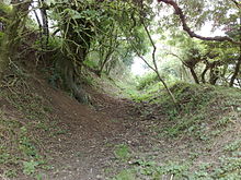 Earthworks around Hinton Hill just north of Dyrham | |||||||
| |||||||
| Belligerents | |||||||
| West Saxons | Britons of Bath, Gloucester, and Cirencester | ||||||
| Commanders and leaders | |||||||
The Battle of Deorham (or Dyrham) is claimed as a decisive military encounter between the West Saxons and the Britons of the West Country in 577. The battle, which was a major victory for Wessex's forces led by Ceawlin and his son, Cuthwine, resulted in the capture of the Brythonic cities of Glevum (Gloucester), Corinium Dobunnorum (Cirencester), and Aquae Sulis (Bath). It also led to the permanent cultural and ethnic separation of Dumnonia (Devon and Cornwall) from Wales.
Account[]
The Anglo-Saxon Chronicle (The A or 'Winchester Manuscript') entry for 577 reads:
"577 Here Cuthwine and Ceawlin fought against the Britons, and they killed 3 kings, Coinmail, Condidan and Farinmail, in the place which is called Deorham, and took 3 cities: Gloucester and Cirencester and Bath"[1]
Deorham is generally taken to be Dyrham in what is now South Gloucestershire, on the Cotswolds escarpment a few miles north of Bath. This entry in the Anglo-Saxon Chronicle is the only evidence for the battle.
Historicity[]
Some scholars have questioned whether the entry in the ninth-century Anglo-Saxon Chronicle records a real event. Patrick Sims-Williams has argued that the entry may have been a later invention incorporating elements of an early Welsh source for the names of the kings.[2] The purpose of the entry may have been to legitimate West Saxon claims on part of the territory of the Hwicce in the ninth century.
Presumed strategy and tactics[]
The Severn Valley has always been one of the military keys of Britain, and some of the decisive battles of the Saxon conquest were fought to control it. In 577 Ceawlin advanced from the Thames Valley across the Cotswolds to seize the area and break the power of the Britons in the lower Severn area.[3][4]
Some historians (such as Welbore St Clair Baddeley in 1929) have concluded that the Saxons may have launched a surprise attack and seized the hill fort at Hinton Hill Camp (Dyrham Camp)[5] because it commanded the Avon Valley, and disrupted communications north and south between Bath and her neighbouring Romano-British towns of Gloucester and Cirencester.[6] Once the Saxons were in occupation of the site (and had begun reinforcing the existing Iron Age defensive structures at the site) the Britons of those three towns were compelled to unite and make a combined attempt to dislodge them. Their attempt failed and the three opposing British kings were killed (they are named as Commagil of Gloucester, Condidan of Cirencester, and Farinmagil of Bath). Their routed forces were driven north of the River Severn and south of Bath where it appears they began the construction of the defensive earthwork called the Wansdyke in a doomed attempt to prevent more territory from being lost.
The military historian Lieutenant-Colonel Alfred Burne, employing his theory of 'Inherent Military Probability' opted for a simpler explanation for the battle than Baddeley.[7] In his view Ceawlin was methodically advancing towards the Severn and the three forces of Britons concentrated to stop him. Burne suggests that they formed up along two slight ridges across the trackway that skirted the Forest of Braden, with Hinton Hill Camp behind them as their stores depot – a position similar to that adopted at the Battle of Beranburh in AD 556.[7] Burne pointed out that if the Saxon attack drove the Britons back from their first line onto the second ridge near the edge of the escarpment, the slightest further retreat would leave their flanks open to a downhill pursuit. He speculates that this is what occurred, with the three Briton leaders and their main body being driven back into the fort while the flanking Saxons driving forwards swept round behind the promontory on which the fort stands. A last stand in this position would explain why none of the three Briton leaders was able to escape.[7]
Outcome[]
The battle has been claimed as a major military, cultural, and economic victory for the early Kingdom of Wessex and a blow to the Romano-British because they lost the three cities of Corinium, a provincial capital in the Roman period (Cirencester); Glevum, a former colonia (Gloucester); and Aquae Sulis, a renowned spa and pagan religious centre (Bath). However, archaeological evidence suggests that these towns had been largely abandoned in the early fifth century and lay in ruins by the late sixth century.[8] Eventually the area became part of the minor Anglo-Saxon England kingdom of Hwicce.
Some academics believe the battle was also the starting point when Welsh and Cornish began to become two separate languages.[7] Germanic-speaking Saxons now held the lands between the Celtic peoples in South West England and those in Wales and the English Midlands, whose territory would be conquered by the Angles of Mercia in the 8th century.[9][10] Others point out that, transport by water being then less costly than by land, contact by sea was still readily available, and indeed a Welsh genealogy record states that descendants from the kings of Pengwern founded a dynasty in the Glastonbury region in the 7th century.
In Popular Culture[]
The Battle of Deorham and its aftermath features in the early chapters of Rosemary Sutcliff's historical novel Dawn Wind.
Notes[]
- ^ Swanton, M. (1996). The Anglo-Saxon Chronicles. London: Phoenix. p. 18.
- ^ Sims-Williams, Patrick (1983). "The Settlement of England in Bede and the Chronicle". Anglo-Saxon England. 12: 1–41.
- ^ Morris, pp. 5–6, 255–6.
- ^ Myres, pp. 162–3, 168.
- ^ The Modern Antiquarian
- ^ The importance given the towns more likely reflects ninth and tenth-century polities, of the time the Chronicle was given its present form, than the de-urbanised sixth century; Simon T. Loseby, "Power and towns in Late Roman Britain and early Anglo-Saxon England" in Gisela Ripoll and Josep M. Gurt, eds., Sedes regiae (ann. 400–800), (Barcelona, 2000), esp. pp 329f (on-line text)
- ^ a b c d Burne, pp. 16–21.
- ^ Wacher, John (1995). The Towns of Roman Britain. London: Batsford.
- ^ Morris, pp. 5–6.
- ^ Finberg, pp. 22–3.
References[]
- The Anglo-Saxon Chronicle
- History of War article
- From the Transactions of the Bristol and Gloucestershire Archaeological Society "The Battle of Deorham" by T. G. P. Hallett, 1883–84, Vol. 8, 62–73
- From the Transactions of the Bristol and Gloucestershire Archaeological Society "The Battle of Dyrham AD 577" by Welbore St Clair Baddeley, 1929, Vol. 51, 95–101
- Everything2 entry for the battle
- Lt-Col Alfred H. Burne, More Battlefields of England, London: Methuen, 1952.
- H. P. R. Finberg, The Formation of England, 550–1042, London: Hart-Davis, MacGibbon, 1974/Paladin, 1976.
- John Morris, The Age of Arthur: A History of the British Isles from 350 to 650, London: Weidenfeld & Nicolson, 1973, ISBN 0 297 17601 3.
- J.N.L. Myres, The Oxford History of England: The English Settlements, Oxford: Clarendon, 1986, ISBN 0 19 821719 6.
- The Modern Antiquarian
Coordinates: 51°29′20.76″N 2°22′25.34″W / 51.4891000°N 2.3737056°W

- 577
- 570s
- 570s conflicts
- 6th century in England
- Battles involving the Britons
- Battles involving Wessex
- Military history of Gloucestershire
- South Gloucestershire District