Bay Bulls, Newfoundland and Labrador
This article needs additional citations for verification. (October 2019) |
Bay Bulls | |
|---|---|
Town | |
 Bay Bulls in August, 2006 | |
 Bay Bulls Location of Bay Bulls in Newfoundland | |
| Coordinates: 47°18′57″N 52°48′37″W / 47.3158°N 52.8103°WCoordinates: 47°18′57″N 52°48′37″W / 47.3158°N 52.8103°W | |
| Country | Canada |
| Province | Newfoundland and Labrador |
| settled | 1635-1638 |
| Government | |
| • Mayor | Harold Mullowney |
| Area | |
| • Land | 30.74 km2 (11.87 sq mi) |
| Population (2016)[1] | |
| • Total | 1,500 |
| • Density | 48.8/km2 (126/sq mi) |
| Time zone | UTC-3:30 (Newfoundland Time) |
| • Summer (DST) | UTC-2:30 (Newfoundland Daylight) |
| Area code(s) | 709 |
| Highways | |
| Website | www |

 | |
 | |
| Location | Bay Bulls Newfoundland Canada |
|---|---|
| Coordinates | 47°18′39.2″N 52°44′49.4″W / 47.310889°N 52.747056°W |
| Constructed | 1908 |
| Foundation | concrete base |
| Construction | cast iron tower |
| Tower height | 11.8 metres (39 ft) |
| Tower shape | cylindrical tower with balcony and lantern |
| Markings | white tower and lantern |
| Power source | solar power |
| Operator | Canadian Coast Guard[2][3] |
| Heritage | recognized federal heritage building of Canada |
| Focal height | 62.5 metres (205 ft) |
| Lens | fourth ordered Fresnel lens |
| Range | 7 nautical miles (13 km; 8.1 mi) |
| Characteristic | Fl W 6s. |
| Admiralty no. | H0452 |
| NGA no. | 1872 |
| CCG no. | 508 |
| ARLHS no. | CAN-650 |
Bay Bulls (2016 population: 1,500[1]) is a small fishing town in the province of Newfoundland and Labrador, Canada.
Geography[]
Located in a sheltered bay, it has been home to many fishermen and a strategic location in early times as it is located just a few miles from the capital, St. John's.
History[]
Bay Bulls first appears on a 1592 map drawn by Thomas Hood.
Fortification of the harbour came in 1638 by Governor David Kirke. In 1665, Bay Bulls was raided by Dutch sailors under Admiral De Ruyter. During King William's War, the village was attacked twice. In 1696, Monbeton de St. Ovide de Brouillan, the governor of Placentia, attacked Bay Bulls from the sea, resulting in the scuttling of the English warship HMS Sapphire. Then in 1697 Pierre Le Moyne d'Iberville marched overland from Placentia and attacked Bay Bulls in the Avalon Peninsula Campaign. In 1702, Commodore John Leake of the Royal Navy entered Bay Bulls with several Men of War, and received information about the whereabouts of French ships and unprotected settlements around the Avalon Peninsula, which he then attacked. On June 24, 1762, the French led by Admiral d'Arsac de Ternay, landed seven hundred men who occupied Bay Bulls and marched to St. John's. Bay Bulls suffered its last invasion on September 29, 1796, when Admiral Richery attempted to storm St. John's but finding it well defended; he attacked and burned Bay Bulls instead.
In 1890 the Roman Catholic Church, St. Peter and St. Paul was rebuilt. The gate was initially marked by cannons left over from the battles with the French, then statues of the Saints were added on top, which gave the famous "Canonized Saints of Bay Bulls."
Demographics[]
| Population in 2016 | 1,500 |
| Population change from 2011 | 16.9% |
| Median age (2016) | 39.1 |
| Total number of dwellings (2016) | 565 |
| Land area (km2.) | 30.74 |
| Population Density (per km2) (2016) | 48.8 |
| Source - Statistics Canada[1] | |
Economy[]
Bay Bulls is a fishing community and was established because it is close to the rich fishing grounds on the Grand Banks. Due to its proximity to St. John's, the town is becoming more of a bedroom community for people employed there. Bay Bulls has been at the forefront of many strategies such as fish farming and lately servicing the Oil and Gas industry. The has built a repair facility that services the many oil rigs that drill for oil on the Grand Banks. Tourism has become an important part of the community as well. Four whale and bird watching establishments, as well as several bed-and-breakfast places, attract visitors from all over the world.
Image gallery[]
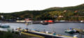
Bay Bulls Harbor
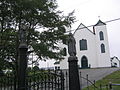
St. Peter and St. Paul Church, showing the "canonized saints"


See also[]
- List of lighthouses in Canada
- List of cities and towns in Newfoundland and Labrador
References[]
- ^ Jump up to: a b c d "Census Profile - Bay Bulls". Statistics Canada. Retrieved 29 October 2016.
- ^ Rowlett, Russ. "Lighthouses of Southeast Newfoundland". The Lighthouse Directory. University of North Carolina at Chapel Hill. Retrieved 2017-02-06.
- ^ List of Lights, Pub. 110: Greenland, The East Coasts of North and South America (Excluding Continental U.S.A. Except the East Coast of Florida) and the West Indies (PDF). List of Lights. United States National Geospatial-Intelligence Agency. 2016.
External links[]
| Wikimedia Commons has media related to Bay Bulls, Newfoundland and Labrador. |
- Aids to Navigation Canadian Coast Guard
- Official town website
- Bay Bulls- Encyclopedia of Newfoundland and Labrador, vol.1, p. 148-149.

| show Lighthouses of Canada |
|---|
| show Authority control |
|---|
- Populated coastal places in Canada
- Towns in Newfoundland and Labrador
- Lighthouses in Newfoundland and Labrador