Bay of Fires

larapuna / the Bay of Fires is a bay on the northeastern coast of Tasmania in Australia, extending from Binalong Bay to Eddystone Point. The bay was given its European name in 1773 by Captain Tobias Furneaux in Adventure,[1] who saw the fires of Aboriginal people on the beaches. larapuna, the Palawa kani name, is recognized as the dual name for the region by the Tasmanian State Government.[2]
Bay whaling activities were carried out in the area in the 1840s.[3]
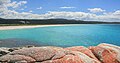
The Bay of Fires is a region of white beaches, blue water and orange-hued granite (the colour of which is actually produced by a lichen). The northern section of the bay is part of Mount William National Park; the southern end is a conservation area.[4]
A wide range of activities can be pursued in the Bay of Fires area, including camping, beach activities, boating, bird watching, fishing, swimming, surfing and walking.[5][6][7]
Tourism[]
In the 2000s, the Bay of Fires received several tourism accolades. In 2005, it was named as the world's second best beach by Condé Nast.[8] In 2008, it was named the world's "hottest" travel destination for 2009 by international guide book Lonely Planet.[9]

History[]
The Bay of Fires was a meeting place for Aboriginal family groups such as Panpe-kanner, Leener-rerter and Pinter-rairer.[10]
Pictures[]

Binalong Bay Beach

Beach and Rocks


| Wikimedia Commons has media related to Bay of Fires. |
References[]
- ^ Sprod, Dan (2005). "Furneaux, Tobias (1735 - 1781)". Australian Dictionary of Biography. Melbourne University Press. ISSN 1833-7538. Retrieved 5 May 2008 – via National Centre of Biography, Australian National University.
- ^ "Tasmanian Aboriginal Centre – Official Aboriginal and Dual Names of places". tacinc.com.au. Retrieved 14 February 2022.
- ^ Evans, Kathryn (1993). Shore-based whaling in Tasmania historical research project: Volume 2; site histories. Hobart: Parks & Wildlife Service. p. 66.
- ^ Fitzgerald, Nick; Bay of Fires Coastal Preservation Lobby (Tas.); North-East Bioregional Network (Tas.) (2009), The Bay of Fires a new national park for Northeast Tasmania, North-East Bioregional Network, retrieved 10 January 2013
- ^ "Bay of Fires". North East Tasmania. Archived from the original on 9 January 2008. Retrieved 13 January 2008.
- ^ "Bay of Fires Conservation Area". Parks and Wildlife Service Tasmania. Archived from the original on 30 January 2009. Retrieved 13 January 2008.
- ^ Richardson, Garry (2006), The Bay of Fires, St Helens and the Hinterland : a brief history and activities to enjoy, G. Richardson,c[2006], retrieved 10 January 2013
- ^ "Bay of Fires named world's second-best beach". ABC News. 12 June 2005. Retrieved 24 December 2020.
- ^ "Tasmania's Bay of Fires world's top spot: Lonely Planet". Sydney Morning Herald. 20 October 2008. Retrieved 24 December 2020.
- ^ "Bay of Fires Conservation Area | Parks & Wildlife Service Tasmania". parks.tas.gov.au. Retrieved 18 April 2021.
Coordinates: 41°08′13″S 148°18′29″E / 41.137°S 148.308°E

East Coast region of Tasmania, Australia | |||||
|---|---|---|---|---|---|
| Settlements | |||||
| Governance former | |||||
| Mountains | |||||
| Protected areas, parks and reserves | |||||
| Harbours, bays, inlets and estuaries | |||||
| Landmarks |
| ||||
| People of note | |||||
| Islands |
| ||||
| Books and newspapers | |||||
| Flora, fauna, and fishlife | |||||
| Bioregions | |||||
| |||||
- East Coast Tasmania
- Beaches of Tasmania
- Bays of Tasmania
- Whaling stations in Australia
- Tasmania geography stubs