Beatriz, Caguas, Puerto Rico
Beatriz | |
|---|---|
Barrio | |
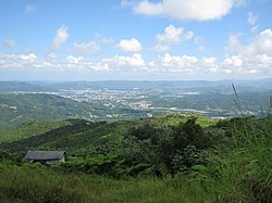 View of Caguas from Cerro Las Piñas in Beatriz | |
 Location of Beatriz within the municipality of Caguas shown in red | |
 Beatriz Location of Puerto Rico | |
| Coordinates: 18°10′23″N 66°04′38″W / 18.173171°N 66.077086°WCoordinates: 18°10′23″N 66°04′38″W / 18.173171°N 66.077086°W[1] | |
| Commonwealth | |
| Municipality | |
| Area | |
| • Total | 6.13 sq mi (15.9 km2) |
| • Land | 6.13 sq mi (15.9 km2) |
| • Water | 0.00 sq mi (0.0 km2) |
| Elevation | 725 ft (221 m) |
| Population (2010) | |
| • Total | 4,353 |
| • Density | 710.1/sq mi (274.2/km2) |
| Source: 2010 Census | |
| Time zone | UTC−4 (AST) |

Beatriz is a barrio in the municipality of Caguas, Puerto Rico. Its population in 2010 was 4,353.[3][4][5]
Geography[]
Beatriz is located at the coordinates 18°10′23″N 66°4′37″W / 18.17306°N 66.07694°W. According to the United States Census Bureau, Beatriz has a total area of 15.89 km², of which 15.89 km² is land and (0.03%) 0.01 km² is water.[5] Beatriz is located in the Sierra de Cayey, a subrange of the Cordillera Central mountain range, making it one of the barrios of Caguas which are not located in the Caguas Valley. The name of the barrio comes from the Doña Beatriz Creek which crosses it and flows into the Turabo River.
Demographics[]
According to the 2010 Census, there were 4,353 people residing in Beatriz. The population density was 27,391 inhabitants per km². Of 4,353 inhabitants, Beatriz was composed of 68.76% Whites, 13% were Black, 0.62% were American Indian, 0.05% were Asian, 0.02% were Pacific Islanders, 12.27% were of other races and 5.28% belonged to two or more races. In all, the population was 99.47% Hispanic or Latino.[5]
| Historical population | |||
|---|---|---|---|
| Census | Pop. | %± | |
| 1900 | 868 | — | |
| 1950 | 2,713 | — | |
| 1980 | 3,543 | — | |
| 1990 | 3,807 | 7.5% | |
| 2000 | 4,467 | 17.3% | |
| 2010 | 4,353 | −2.6% | |
| U.S. Decennial Census[6] 1899 (shown as 1900)[7] 1910-1930[8] 1930-1950[9] 1980-2000[10] 2010[11] | |||
History[]
Puerto Rico was ceded by Spain in the aftermath of the Spanish–American War under the terms of the Treaty of Paris of 1898 and became an unincorporated territory of the United States. In 1899, the United States Department of War conducted a census of Puerto Rico finding that the population of Beatriz barrio was 868.[12]
The area was mostly made up of subsistence farms in the 19th century. Botanist William Edwin Safford visited Beatriz in 1898 to document the local plant life.[13]
The 1899 San Ciriaco hurricane devastated Beatriz, and many farmers began working for the newly established military government of the United States of America building roads.[14] At the time, a store owned by wealthy landowner Don Ramón Álvarez was the center of economic life in Beatriz. In 1900, one of the store's cashiers Don Demetrio López was elected alcalde and comisario of Beatriz.[15]
Beatriz barrio was hit by Hurricane Maria on 20 September 2017 and many residents still did not have electricity as of March 2018, six months later.
Landmarks and places of interest[]
- Carretera Central, the historic road connecting San Juan in the north to Ponce in the south passes through Beatriz.
- Centro Los Panes, a community center near La Jurado sector.
- Cerro Las Piñas, a hill located in the boundary with Beatriz, Cayey which offers panoramic views of the Caguas Valley and its surrounding mountains.
See also[]
References[]
- ^ a b "US Gazetteer 2019". US Census. US Government.
- ^ U.S. Geological Survey Geographic Names Information System: Beatriz barrio
- ^ Picó, Rafael; Buitrago de Santiago, Zayda; Berrios, Hector H. Nueva geografía de Puerto Rico: física, económica, y social, por Rafael Picó. Con la colaboración de Zayda Buitrago de Santiago y Héctor H. Berrios. San Juan Editorial Universitaria, Universidad de Puerto Rico,1969.
- ^ Gwillim Law (20 May 2015). Administrative Subdivisions of Countries: A Comprehensive World Reference, 1900 through 1998. McFarland. p. 300. ISBN 978-1-4766-0447-3. Retrieved 25 December 2018.
- ^ a b c Puerto Rico:2010:population and housing unit counts.pdf (PDF). U.S. Dept. of Commerce, Economics and Statistics Administration, U.S. Census Bureau. 2010.
- ^ "U.S. Decennial Census". United States Census Bureau. Archived from the original on February 13, 2020. Retrieved September 21, 2017.
- ^ "Report of the Census of Porto Rico 1899". War Department Office Director Census of Porto Rico. Archived from the original on July 16, 2017. Retrieved September 21, 2017.
- ^ "Table 3-Population of Municipalities: 1930 1920 and 1910" (PDF). United States Census Bureau. Archived (PDF) from the original on August 17, 2017. Retrieved September 21, 2017.
- ^ "Table 4-Area and Population of Municipalities Urban and Rural: 1930 to 1950" (PDF). United States Census Bureau. Archived (PDF) from the original on August 30, 2015. Retrieved September 21, 2014.
- ^ "Table 2 Population and Housing Units: 1960 to 2000" (PDF). United States Census Bureau. Archived (PDF) from the original on July 24, 2017. Retrieved September 21, 2017.
- ^ Puerto Rico:2010:population and housing unit counts.pdf (PDF). U.S. Dept. of Commerce Economics and Statistics Administration U.S. Census Bureau. 2010. Archived (PDF) from the original on 2017-02-20. Retrieved 2019-08-02.
- ^ Joseph Prentiss Sanger; Henry Gannett; Walter Francis Willcox (1900). Informe sobre el censo de Puerto Rico, 1899, United States. War Dept. Porto Rico Census Office (in Spanish). Imprenta del gobierno. p. 162.
- ^ William Edwin Safford (April 1912). "Notes of a naturalist afloat". American Fern Journal. 2 (2): 40.
- ^ Rosa E. Carrasquillo (2006). Our Landless Patria: Marginal Citizenship and Race in Caguas, Puerto Rico. University of Nebraska Press. p. 86. ISBN 0803215371.
- ^ Rosa E. Carrasquillo (2006). Our Landless Patria: Marginal Citizenship and Race in Caguas, Puerto Rico. University of Nebraska Press. p. 32. ISBN 0803215371.
External links[]
- Barrios of Caguas, Puerto Rico