Beattystown Historic District
Beattystown Historic District | |
 | |
 Beattystown Historic District | |
| Location | Junction of New Jersey Route 57 and Kings Highway Beattystown, New Jersey |
|---|---|
| Coordinates | 40°48′49″N 74°50′34″W / 40.81361°N 74.84278°WCoordinates: 40°48′49″N 74°50′34″W / 40.81361°N 74.84278°W |
| Area | 35 acres (14 ha) |
| Architectural style | Greek Revival, Stick/eastlake |
| NRHP reference No. | 90001449[1] |
| NJRHP No. | 2770[2] |
| Significant dates | |
| Added to NRHP | September 28, 1990 |
| Designated NJRHP | August 10, 1990 |


The Beattystown Historic District is a historic district in the village of Beattystown, Mansfield Township, Warren County, New Jersey. The district was added to the National Register of Historic Places on September 28, 1990 for its significance in architecture, commerce, industry, and settlement pattern from 1762 to 1929. It includes 32 contributing buildings.[3]
History[]
Beattystown was founded c. 1762 with establishment of the George Beatty Mill along the Musconetcong River.[3]
Gallery of contributing properties[]

Welcome to Beattystown Historic District

Former Presbyterian Church
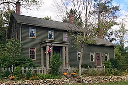
Vernacular style frame house


Iron Ore Scale House, Johnson General Store, and S.B. Fisher Grist Mill

References[]
- ^ "National Register Information System". National Register of Historic Places. National Park Service. November 2, 2013.
- ^ "New Jersey and National Registers of Historic Places - Warren County" (PDF). New Jersey Department of Environmental Protection - Historic Preservation Office. September 13, 2018. p. 1.
- ^ a b Thomas E. Jones (April 3, 1989). "National Register of Historic Places Registration: Beattystown Historic District". National Park Service. With accompanying 21 photos from 1989
Categories:
- Mansfield Township, Warren County, New Jersey
- National Register of Historic Places in Warren County, New Jersey
- New Jersey Register of Historic Places
- Buildings and structures in Warren County, New Jersey
- Historic districts on the National Register of Historic Places in New Jersey
- Greek Revival architecture in New Jersey
- Queen Anne architecture in New Jersey
- New Jersey Registered Historic Place stubs