Beech Grove, McLean County, Kentucky
Beech Grove, Kentucky | |
|---|---|
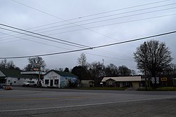 Intersection of KY 56 and KY 136 in Beech Grove | |
 Beech Grove, Kentucky | |
| Coordinates: 37°36′58″N 87°23′47″W / 37.61611°N 87.39639°WCoordinates: 37°36′58″N 87°23′47″W / 37.61611°N 87.39639°W | |
| Country | United States |
| State | Kentucky |
| County | McLean |
| Area | |
| • Total | 1.858 sq mi (4.81 km2) |
| • Land | 1.845 sq mi (4.78 km2) |
| • Water | 0.013 sq mi (0.03 km2) |
| Elevation | 410 ft (120 m) |
| Population | |
| • Total | 243 |
| • Density | 130/sq mi (50/km2) |
| Time zone | UTC-6 (Central (CST)) |
| • Summer (DST) | UTC-5 (CDT) |
| ZIP code | 42322 |
| Area codes | 270 & 364 |
| GNIS feature ID | 486710[2] |


Beech Grove is an unincorporated community and census-designated place in McLean County, Kentucky, United States. Its population was 243 as of the 2010 census.[1] Beech Grove has a post office with ZIP code 42322, which opened on April 29, 1878.[3][4] Kentucky Route 56, Kentucky Route 136, and Kentucky Route 256 pass through the community.
Geography[]
According to the U.S. Census Bureau, the community has an area of 1.858 square miles (4.81 km2); 1.845 square miles (4.78 km2) of its area is land, and 0.013 square miles (0.034 km2) is water.[1]
References[]
- ^ a b c d "2010 Census Gazetteer Files - Places: Kentucky". U.S. Census Bureau. Retrieved April 15, 2017.
- ^ "Beech Grove". Geographic Names Information System. United States Geological Survey.
- ^ United States Postal Service. "USPS - Look Up a ZIP Code". Retrieved April 15, 2017.
- ^ "Postmaster Finder - Post Offices by ZIP Code". United States Postal Service. Retrieved April 15, 2017.
Municipalities and communities of McLean County, Kentucky, United States | ||
|---|---|---|
| Cities |  | |
| CDP | ||
| Unincorporated communities | ||
| ||
This McLean County, Kentucky state location article is a stub. You can help Wikipedia by . |
Categories:
- Unincorporated communities in McLean County, Kentucky
- Unincorporated communities in Kentucky
- Census-designated places in McLean County, Kentucky
- Census-designated places in Kentucky
- Kentucky geography stubs