Bel Air Church
This article has multiple issues. Please help or discuss these issues on the talk page. (Learn how and when to remove these template messages)
|
| Bel Air Church | |
|---|---|
 | |
 | |
| Location | 16221 Mulholland Drive, Los Angeles, CA 90049 |
| Country | United States |
| Denomination | Presbyterian Church (USA) |
| Website | [1] [2] |
| History | |
| Founded | 1956 |
| Clergy | |
| Senior pastor(s) | Dr. Drew Sams |
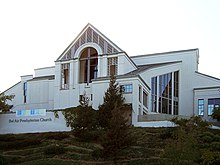
Bel Air Church (also known as Bel Air Presbyterian Church) is a member of the Presbyterian Church (USA), and has a campus located on the famed Mulholland Drive in the Bel Air neighborhood of Los Angeles, California.[1] An iconic Los Angeles church, it has been listed on the top 10 most visited churches in Los Angeles.[2]
History and facility[]
Since its founding in 1956, Bel Air Church has become one of the most influential churches in Los Angeles. The church is on the "Educational Corridor" on Mulholland Drive, on a hill overlooking the San Fernando Valley. On Jewish high holy days, Bel Air Church hosts services for the Stephen S. Wise Temple, a Reform Jewish congregation, which is in the same Bel Air neighborhood.[3]
The original sanctuary organ was a four-manual, sixty-eight rank mechanical action pipe organ by Casavant. It was seriously damaged, mostly by water leakage, in the 1994 Northridge earthquake. It was later rebuilt as a pipe combination instrument with a digital console from Rodgers Instruments Corporation, in protest of which Casavant declared it to be "destroyed" and stricken from their register of surviving instruments.[citation needed] At the time of its re-dedication, it was one of the largest digital/pipe combination organs in the world.
In 2007, the church completed a $12 million campus expansion program, The Campaign for Bel Air: Phase I, which included the two story Education Building, Discipleship Center, and Administration Building, including staff offices with stunning views overlooking the San Fernando Valley. The campus also has a full-service cafe.
Former Senior Pastors include Rev. Dr. Louis H. Evans Jr., Rev. Dr. Mark Brewer, Rev. Dr. Michael H. Wenning, Rev. Paul Pierson, Rev. Dr. David G. McKechnie, Dr. Donn D. Moomaw, Rev. Dr. Michael Wenning, and Dr. Mark Brewer.
Rev. Dr. Moomaw gave the invocation at President Ronald Reagan's first inauguration in 1981. Rev. Dr. Wenning gave the invocation at President Reagan's state funeral.[4]
Rev. Dr. Moomaw presided over a private service for the family of First Lady Nancy Reagan before her state funeral at the Reagan Library.

Rev. Dr. Drew Sams was officially ordained as the church's Senior Pastor and Head of Staff on April 13, 2014.[5] where he joined Rev. Care Crawford, Rev. Kim Dorr-Tilley, and later Rev. Mike Morgan.
Congregation[]

Many members of Bel Air Church are involved in the entertainment industry, and many are prominent leaders across every industry in the Los Angeles community.[6]
Activities[]
Bel Air Church is a founder of Imagine LA, a mentorship program that matches families exiting homelessness with volunteer teams from faith communities, corporations, and other committed organizations.[7]
Bel Air Church has an extensive outreach department which partners with other community service organizations in Los Angeles.
For over twenty-five years Bel Air Church has packed and distributed over 10,000 meals to those in need at Thanksgiving.[8]
References[]
- ^ "History". Bel Air Church – History. Retrieved 2015-10-12.
- ^ "THE 10 BEST Los Angeles Churches Trending in 2021".
- ^ "Our Clergy Responds to Divestment Vote by Presbyterian Church (U.S.A)". Stephen Wise Temple. Archived from the original on 2016-12-30. Retrieved 2015-10-12.
- ^ "Michael Wenning, Reagans' Pastor, Dies at 75". The New York Times. June 30, 2011. Retrieved 2015-10-12.
- ^ "Bel Air Leadership". Bel Air Church. Retrieved 2015-10-12.
- ^ "Hollywood at Church: Where the A-List Prays". 24 December 2012.
- ^ "Fact Sheet" (PDF). ImagineLA. Archived from the original (PDF) on 2014-11-30. Retrieved 2015-10-12.
- ^ "Bel Air Church to Provide 10,000 People with Thanksgiving Meal".
External links[]
Coordinates: 34°07′50″N 118°29′07″W / 34.130581°N 118.485296°W
- Presbyterian Church (USA) churches
- Presbyterian churches in California
- Churches in Los Angeles
- Christian organizations established in 1956
- Presbyterian organizations established in the 20th century
- Bel Air, Los Angeles
- Ronald Reagan
- Nancy Reagan


