Bellegarde-sur-Valserine
Bellegarde-sur-Valserine
Bèlagouârda (Arpitan) | |
|---|---|
Part of Valserhône | |
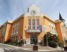 Former Bellegarde-sur-Valserine Town Hall and current Valserhône Town Hall | |
 Coat of arms | |
show Location of Bellegarde-sur-Valserine | |
 Bellegarde-sur-Valserine | |
| Coordinates: 46°06′30″N 5°49′36″E / 46.1083°N 5.8267°ECoordinates: 46°06′30″N 5°49′36″E / 46.1083°N 5.8267°E | |
| Country | France |
| Region | Auvergne-Rhône-Alpes |
| Department | Ain |
| Arrondissement | Nantua |
| Canton | Bellegarde-sur-Valserine |
| Commune | Valserhône |
| Area 1 | 15 km2 (6 sq mi) |
| Population (2017)[1] | 11,675 |
| • Density | 780/km2 (2,000/sq mi) |
| Time zone | UTC+01:00 (CET) |
| • Summer (DST) | UTC+02:00 (CEST) |
| Postal code | 01200 |
| Elevation | 330–1,542 m (1,083–5,059 ft) (avg. 485 m or 1,591 ft) |
| 1 French Land Register data, which excludes lakes, ponds, glaciers > 1 km2 (0.386 sq mi or 247 acres) and river estuaries. | |


Bellegarde-sur-Valserine (French pronunciation: [bɛlɡaʁd syʁ valsəʁin], literally Bellegarde on Valserine; Arpitan: Bèlagouârda) is a former commune in the Ain department in the Auvergne-Rhône-Alpes region in Eastern France. In 2017, it had a population of 11,675. On 1 January 2019, it was merged into the new commune of Valserhône.[2]
Geography[]
Bellegarde is located at the confluence of the Valserine and the Rhône.
At this spot, the water of the two rivers runs underground; it was possible to cross both of them easily. Since the inception of the Génissiat Dam at Injoux-Génissiat, the level of the Rhône was raised several metres and the Perte du Rhône submerged. A smaller similar feature, the Pertes de la Valserine, on the former border with Lancrans, is still visible.
Bellegarde lies in a valley dominated by the Plateau of Retord on the west and the massif of the Grand Crêt d'Eau and the Vuache on the east. The passage created by the Rhône is the principal access to the area around Gex and the north of Lake Geneva. Since 1 January 2019, Bellegarde belongs to a new commune, with Lancrans and Châtillon-en-Michaille, named Valserhône.


Climate[]
Bellegarde features an oceanic climate (Cfb) under the Köppen system. However, its position in a valley, near the Jura mountains and far from the ocean generates often cold, snowy winters with frequent temperatures below freezing, and warm to hot, stormy summers.
| hideClimate data for Bellegarde-sur-Valserine, Valserhône, Ain, France, Alt. : 350 m, (1994-2010) | |||||||||||||
|---|---|---|---|---|---|---|---|---|---|---|---|---|---|
| Month | Jan | Feb | Mar | Apr | May | Jun | Jul | Aug | Sep | Oct | Nov | Dec | Year |
| Average high °C (°F) | 5.6 (42.1) |
8.3 (46.9) |
12.5 (54.5) |
16.3 (61.3) |
21.0 (69.8) |
24.9 (76.8) |
27.1 (80.8) |
26.3 (79.3) |
21.6 (70.9) |
17.0 (62.6) |
10.1 (50.2) |
5.7 (42.3) |
16.4 (61.5) |
| Daily mean °C (°F) | 1.9 (35.4) |
3.5 (38.3) |
6.7 (44.1) |
10.2 (50.4) |
14.8 (58.6) |
18.2 (64.8) |
20.2 (68.4) |
19.7 (67.5) |
15.6 (60.1) |
11.8 (53.2) |
6.0 (42.8) |
2.3 (36.1) |
10.9 (51.6) |
| Average low °C (°F) | −1.9 (28.6) |
−1.4 (29.5) |
0.9 (33.6) |
4.0 (39.2) |
8.5 (47.3) |
11.5 (52.7) |
13.3 (55.9) |
13.0 (55.4) |
9.5 (49.1) |
6.6 (43.9) |
1.9 (35.4) |
−1.2 (29.8) |
5.4 (41.7) |
| Average precipitation mm (inches) | 109.5 (4.31) |
96.6 (3.80) |
91.9 (3.62) |
87.2 (3.43) |
94.0 (3.70) |
74.3 (2.93) |
85.7 (3.37) |
100.2 (3.94) |
100.6 (3.96) |
106.0 (4.17) |
121.2 (4.77) |
118.2 (4.65) |
1,185.4 (46.65) |
| Source: NOAA | |||||||||||||
Traffic[]
Bellegarde is the transfer station to the Swiss Jura Foot Railway.
Population[]
| Year | Pop. | ±% |
|---|---|---|
| 2006 | 11,497 | — |
| 2007 | 11,367 | −1.1% |
| 2008 | 11,404 | +0.3% |
| 2009 | 11,679 | +2.4% |
| 2010 | 11,790 | +1.0% |
| 2011 | 11,630 | −1.4% |
| 2012 | 11,590 | −0.3% |
| 2013 | 11,644 | +0.5% |
| 2014 | 11,745 | +0.9% |
| 2015 | 11,809 | +0.5% |
| 2016 | 11,666 | −1.2% |
Twin towns — sister cities[]
Bellegarde-sur-Valserine is twinned with:
 Saint-Christophe, Aosta Valley, Italy (2000)
 Bretten, Germany (2001)
References[]
- ^ Téléchargement du fichier d'ensemble des populations légales en 2017, INSEE
- ^ Arrêté préfectoral, 22 October 2018 (in French)
| Wikimedia Commons has media related to Bellegarde-sur-Valserine. |
| show Authority control |
|---|
- Former communes of Ain
- Bugey
- Populated places disestablished in 2019