Valserhône
Valserhône | |
|---|---|
Commune | |
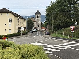 A view of Lancrans | |
show Location of Valserhône | |
 Valserhône | |
| Coordinates: 46°06′30″N 5°49′36″E / 46.1083°N 5.8267°ECoordinates: 46°06′30″N 5°49′36″E / 46.1083°N 5.8267°E | |
| Country | France |
| Region | Auvergne-Rhône-Alpes |
| Department | Ain |
| Arrondissement | Nantua |
| Canton | Valserhône |
| Intercommunality | Pays Bellegardien |
| Government | |
| • Mayor (2020–2026) | Régis Petit |
| Area 1 | 62.54 km2 (24.15 sq mi) |
| Population (Jan. 2018)[1] | 16,431 |
| • Density | 260/km2 (680/sq mi) |
| Time zone | UTC+01:00 (CET) |
| • Summer (DST) | UTC+02:00 (CEST) |
| INSEE/Postal code | 01033 /01200 |
| Elevation | 330–1,606 m (1,083–5,269 ft) (avg. 485 m or 1,591 ft) |
| 1 French Land Register data, which excludes lakes, ponds, glaciers > 1 km2 (0.386 sq mi or 247 acres) and river estuaries. | |


Valserhône (French pronunciation: [valsəʁon] (![]() listen)) is a commune in the Ain department in the Auvergne-Rhône-Alpes region in Eastern France. It is the result of the merger, on 1 January 2019, of the communes of Bellegarde-sur-Valserine, Châtillon-en-Michaille and Lancrans.[2] In 2018, the three communes had a combined population of 16,431, with Bellegarde-sur-Valserine as the major population centre. This makes Valserhône the third-most populated commune of Ain, after Bourg-en-Bresse and Oyonnax.
listen)) is a commune in the Ain department in the Auvergne-Rhône-Alpes region in Eastern France. It is the result of the merger, on 1 January 2019, of the communes of Bellegarde-sur-Valserine, Châtillon-en-Michaille and Lancrans.[2] In 2018, the three communes had a combined population of 16,431, with Bellegarde-sur-Valserine as the major population centre. This makes Valserhône the third-most populated commune of Ain, after Bourg-en-Bresse and Oyonnax.
Geography[]
Valserhône is located at the confluence of the Valserine and the Rhône. It was named after the two rivers. The commune is part of Haut-Jura Regional Natural Park.
The commune has a station, Bellegarde, which is located at the junction of three railway lines and has regular service to various destinations in France and Switzerland.
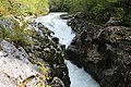
The Valserine in Valserhône

Église Saint-Paul de Vouvray in Châtillon-en-Michaille
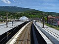
Bellegarde station


See also[]
References[]
- ^ "Populations légales 2018". INSEE. 28 December 2020.
- ^ Arrêté préfectoral, 22 October 2018 (in French)
| Wikimedia Commons has media related to Valserhône. |
- Communes of Ain
- Populated places established in 2019
- 2019 establishments in France