Chanay
This article may be expanded with text translated from the corresponding article in French. (December 2008) Click [show] for important translation instructions.
|
Chanay | |
|---|---|
Commune | |
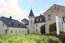 Château Quinsonnas | |
 Flag | |
Location of Chanay  | |
 Chanay | |
| Coordinates: 46°00′00″N 5°47′00″E / 46°N 5.7833°ECoordinates: 46°00′00″N 5°47′00″E / 46°N 5.7833°E | |
| Country | France |
| Region | Auvergne-Rhône-Alpes |
| Department | Ain |
| Arrondissement | Nantua |
| Canton | Valserhône |
| Intercommunality | |
| Government | |
| • Mayor (2020–2026) | Henri Caldairou |
| Area 1 | 18.10 km2 (6.99 sq mi) |
| Population (Jan. 2018)[1] | 627 |
| • Density | 35/km2 (90/sq mi) |
| Time zone | UTC+01:00 (CET) |
| • Summer (DST) | UTC+02:00 (CEST) |
| INSEE/Postal code | 01082 /01420 |
| Elevation | 260–1,184 m (853–3,885 ft) (avg. 485 m or 1,591 ft) |
| 1 French Land Register data, which excludes lakes, ponds, glaciers > 1 km2 (0.386 sq mi or 247 acres) and river estuaries. | |


Chanay (French pronunciation: [ʃanɛ]) is a commune in the Ain department in eastern France.
Population[]
| Year | Pop. | ±% |
|---|---|---|
| 2006 | 601 | — |
| 2007 | 602 | +0.2% |
| 2008 | 610 | +1.3% |
| 2009 | 608 | −0.3% |
| 2010 | 617 | +1.5% |
| 2011 | 627 | +1.6% |
| 2012 | 636 | +1.4% |
| 2013 | 646 | +1.6% |
| 2014 | 648 | +0.3% |
| 2015 | 640 | −1.2% |
| 2016 | 633 | −1.1% |
See also[]
References[]
- ^ "Populations légales 2018". The National Institute of Statistics and Economic Studies. 28 December 2020.
| Wikimedia Commons has media related to Chanay. |
This Ain geographical article is a stub. You can help Wikipedia by . |
Categories:
- Communes of Ain
- Ain geography stubs