Izenave
show This article may be expanded with text translated from the corresponding article in French. (December 2008) Click [show] for important translation instructions. |
Izenave | |
|---|---|
Commune | |
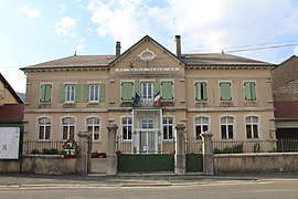 The town hall in Izenave | |
 Coat of arms | |
show Location of Izenave | |
 Izenave | |
| Coordinates: 46°02′20″N 5°31′33″E / 46.0389°N 5.5258°ECoordinates: 46°02′20″N 5°31′33″E / 46.0389°N 5.5258°E | |
| Country | France |
| Region | Auvergne-Rhône-Alpes |
| Department | Ain |
| Arrondissement | Nantua |
| Canton | Hauteville-Lompnes |
| Government | |
| • Mayor (2020–2026) | Thiery Druet[1] |
| Area 1 | 13.04 km2 (5.03 sq mi) |
| Population (Jan. 2018)[2] | 157 |
| • Density | 12/km2 (31/sq mi) |
| Time zone | UTC+01:00 (CET) |
| • Summer (DST) | UTC+02:00 (CEST) |
| INSEE/Postal code | 01191 /01430 |
| Elevation | 663–1,008 m (2,175–3,307 ft) (avg. 690 m or 2,260 ft) |
| 1 French Land Register data, which excludes lakes, ponds, glaciers > 1 km2 (0.386 sq mi or 247 acres) and river estuaries. | |


Izenave is a commune in the Ain department in eastern France.
Population[]
| Year | Pop. | ±% |
|---|---|---|
| 1962 | 177 | — |
| 1968 | 169 | −4.5% |
| 1975 | 138 | −18.3% |
| 1982 | 117 | −15.2% |
| 1990 | 130 | +11.1% |
| 1999 | 146 | +12.3% |
| 2008 | 152 | +4.1% |
See also[]
References[]
- ^ "Répertoire national des élus: les maires". data.gouv.fr, Plateforme ouverte des données publiques françaises (in French). 2 December 2020.
- ^ "Populations légales 2018". INSEE. 28 December 2020.
| Wikimedia Commons has media related to Izenave. |
This Ain geographical article is a stub. You can help Wikipedia by . |
Categories:
- Communes of Ain
- Ain geography stubs