Charix
show This article may be expanded with text translated from the corresponding article in French. (December 2008) Click [show] for important translation instructions. |
Charix | |
|---|---|
Commune | |
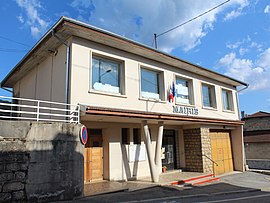 The town hall in Charix | |
show Location of Charix | |
 Charix | |
| Coordinates: 46°11′03″N 5°41′05″E / 46.1842°N 5.6847°ECoordinates: 46°11′03″N 5°41′05″E / 46.1842°N 5.6847°E | |
| Country | France |
| Region | Auvergne-Rhône-Alpes |
| Department | Ain |
| Arrondissement | Nantua |
| Canton | Nantua |
| Intercommunality | Haut-Bugey Agglomération |
| Government | |
| • Mayor (2020–2026) | Didier Palisson[1] |
| Area 1 | 18.27 km2 (7.05 sq mi) |
| Population (Jan. 2018)[2] | 281 |
| • Density | 15/km2 (40/sq mi) |
| Time zone | UTC+01:00 (CET) |
| • Summer (DST) | UTC+02:00 (CEST) |
| INSEE/Postal code | 01087 /01130 |
| Elevation | 580–1,046 m (1,903–3,432 ft) (avg. 780 m or 2,560 ft) |
| 1 French Land Register data, which excludes lakes, ponds, glaciers > 1 km2 (0.386 sq mi or 247 acres) and river estuaries. | |


Charix is a commune in the Ain department in eastern France.
Population[]
| Year | Pop. | ±% |
|---|---|---|
| 2006 | 289 | — |
| 2007 | 292 | +1.0% |
| 2008 | 297 | +1.7% |
| 2009 | 300 | +1.0% |
| 2010 | 294 | −2.0% |
| 2011 | 289 | −1.7% |
| 2012 | 283 | −2.1% |
| 2013 | 284 | +0.4% |
| 2014 | 284 | +0.0% |
| 2015 | 285 | +0.4% |
| 2016 | 285 | +0.0% |
See also[]
References[]
- ^ "Répertoire national des élus: les maires". data.gouv.fr, Plateforme ouverte des données publiques françaises (in French). 2 December 2020.
- ^ "Populations légales 2018". INSEE. 28 December 2020.
External links[]
| Wikimedia Commons has media related to Charix. |
This Ain geographical article is a stub. You can help Wikipedia by . |
Categories:
- Communes of Ain
- Ain geography stubs