Montceaux
show This article may be expanded with text translated from the corresponding article in French. (December 2008) Click [show] for important translation instructions. |
Montceaux | |
|---|---|
Commune | |
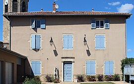 The town hall in Montceaux | |
 Coat of arms | |
show Location of Montceaux | |
 Montceaux | |
| Coordinates: 46°05′50″N 4°47′53″E / 46.0972°N 4.7981°ECoordinates: 46°05′50″N 4°47′53″E / 46.0972°N 4.7981°E | |
| Country | France |
| Region | Auvergne-Rhône-Alpes |
| Department | Ain |
| Arrondissement | Bourg-en-Bresse |
| Canton | Châtillon-sur-Chalaronne |
| Intercommunality | |
| Government | |
| • Mayor (2020–2026) | Jean-Claude Deschizeaux[1] |
| Area 1 | 10.03 km2 (3.87 sq mi) |
| Population (Jan. 2018)[2] | 1,188 |
| • Density | 120/km2 (310/sq mi) |
| Time zone | UTC+01:00 (CET) |
| • Summer (DST) | UTC+02:00 (CEST) |
| INSEE/Postal code | 01258 /01090 |
| Elevation | 180–244 m (591–801 ft) |
| 1 French Land Register data, which excludes lakes, ponds, glaciers > 1 km2 (0.386 sq mi or 247 acres) and river estuaries. | |


Montceaux is a commune in the Ain department in eastern France.
Population[]
| Year | Pop. | ±% |
|---|---|---|
| 2006 | 1,041 | — |
| 2007 | 1,054 | +1.2% |
| 2008 | 1,063 | +0.9% |
| 2009 | 1,113 | +4.7% |
| 2010 | 1,164 | +4.6% |
| 2011 | 1,214 | +4.3% |
| 2012 | 1,222 | +0.7% |
| 2013 | 1,226 | +0.3% |
| 2014 | 1,211 | −1.2% |
| 2015 | 1,197 | −1.2% |
| 2016 | 1,182 | −1.3% |
See also[]
References[]
- ^ "Répertoire national des élus: les maires". data.gouv.fr, Plateforme ouverte des données publiques françaises (in French). 2 December 2020.
- ^ "Populations légales 2018". INSEE. 28 December 2020.
| Wikimedia Commons has media related to Montceaux. |
This Ain geographical article is a stub. You can help Wikipedia by . |
Categories:
- Communes of Ain
- Ain geography stubs