Mézériat
show This article may be expanded with text translated from the corresponding article in French. (December 2008) Click [show] for important translation instructions. |
Mézériat | |
|---|---|
Commune | |
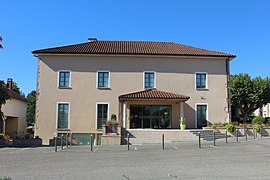 The town hall in Mézériat | |
show Location of Mézériat | |
 Mézériat | |
| Coordinates: 46°14′07″N 5°02′52″E / 46.2353°N 5.0478°ECoordinates: 46°14′07″N 5°02′52″E / 46.2353°N 5.0478°E | |
| Country | France |
| Region | Auvergne-Rhône-Alpes |
| Department | Ain |
| Arrondissement | Bourg-en-Bresse |
| Canton | Vonnas |
| Intercommunality | Veyle |
| Government | |
| • Mayor (2020–2026) | Guy Dupuit |
| Area 1 | 19.17 km2 (7.40 sq mi) |
| Population (Jan. 2018)[1] | 2,195 |
| • Density | 110/km2 (300/sq mi) |
| Time zone | UTC+01:00 (CET) |
| • Summer (DST) | UTC+02:00 (CEST) |
| INSEE/Postal code | 01246 /01660 |
| Elevation | 189–223 m (620–732 ft) |
| 1 French Land Register data, which excludes lakes, ponds, glaciers > 1 km2 (0.386 sq mi or 247 acres) and river estuaries. | |


Mézériat is a commune in the Ain department in eastern France.
Geography[]
The Veyle flows west through the southern part of the commune, crosses the village, then flows southwest and forms part of the commune's southwestern border.
Population[]
|
|
See also[]
References[]
- ^ "Populations légales 2018". INSEE. 28 December 2020.
External links[]
| Wikimedia Commons has media related to Mézériat. |
| Authority control |
|
|---|
This Ain geographical article is a stub. You can help Wikipedia by . |
Categories:
- Communes of Ain
- Ain geography stubs