Saint-Denis-lès-Bourg
show This article may be expanded with text translated from the corresponding article in French. (December 2008) Click [show] for important translation instructions. |
Saint Denis les Bourg | |
|---|---|
Commune | |
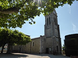 The Church of Saint Denis | |
 Coat of arms | |
show Location of Saint Denis les Bourg | |
 Saint Denis les Bourg | |
| Coordinates: 46°12′09″N 5°11′24″E / 46.2025°N 5.19°ECoordinates: 46°12′09″N 5°11′24″E / 46.2025°N 5.19°E | |
| Country | France |
| Region | Auvergne-Rhône-Alpes |
| Department | Ain |
| Arrondissement | Bourg-en-Bresse |
| Canton | Bourg-en-Bresse-2 |
| Intercommunality | Bassin de Bourg-en-Bresse |
| Government | |
| • Mayor (2020–2026) | Guillaume Fauvet[1] |
| Area 1 | 12.58 km2 (4.86 sq mi) |
| Population (Jan. 2018)[2] | 5,845 |
| • Density | 460/km2 (1,200/sq mi) |
| Time zone | UTC+01:00 (CET) |
| • Summer (DST) | UTC+02:00 (CEST) |
| INSEE/Postal code | 01344 /01000 |
| Elevation | 209–242 m (686–794 ft) |
| 1 French Land Register data, which excludes lakes, ponds, glaciers > 1 km2 (0.386 sq mi or 247 acres) and river estuaries. | |


Saint-Denis-lès-Bourg is a commune in the Ain department in eastern France.
Geography[]
The Veyle forms the commune's western border.
Population[]
| Year | Pop. | ±% |
|---|---|---|
| 2004 | 4,910 | — |
| 2006 | 4,967 | +1.2% |
| 2007 | 5,101 | +2.7% |
| 2008 | 5,229 | +2.5% |
| 2009 | 5,357 | +2.4% |
| 2010 | 5,405 | +0.9% |
| 2011 | 5,492 | +1.6% |
| 2012 | 5,504 | +0.2% |
| 2013 | 5,505 | +0.0% |
| 2014 | 5,505 | +0.0% |
| 2015 | 5,530 | +0.5% |
| 2016 | 5,667 | +2.5% |
Politics[]
Presidential Elections 2nd Round [3][]
| Election | Winning Candidate | Party | % | |
|---|---|---|---|---|
| 2017 | Emmanuel Macron | EM | 70.64 | |
| 2012 | Nicolas Sarkozy | UMP | 52.28 | |
| 2007 | Nicolas Sarkozy | UMP | 57.38 | |
| 2002 | Jacques Chirac | RPR | 84.35 | |
See also[]
References[]
- ^ "Répertoire national des élus: les maires". data.gouv.fr, Plateforme ouverte des données publiques françaises (in French). 2 December 2020.
- ^ "Populations légales 2018". INSEE. 28 December 2020.
- ^ "Résultats France - Présidentielle 2017 - 1er et 2nd tour".
| Wikimedia Commons has media related to Saint-Denis-lès-Bourg. |
| show Authority control |
|---|
This Ain geographical article is a stub. You can help Wikipedia by . |
Categories:
- Communes of Ain
- Ain geography stubs