Échenevex
This article may be expanded with text translated from the corresponding article in French. (December 2008) Click [show] for important translation instructions.
|
Échenevex | |
|---|---|
Commune | |
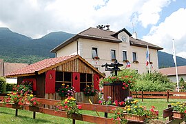 Town hall | |
 Coat of arms | |
Location of Échenevex  | |
 Échenevex | |
| Coordinates: 46°18′34″N 6°02′12″E / 46.3094°N 6.0367°ECoordinates: 46°18′34″N 6°02′12″E / 46.3094°N 6.0367°E | |
| Country | France |
| Region | Auvergne-Rhône-Alpes |
| Department | Ain |
| Arrondissement | Gex |
| Canton | Thoiry |
| Intercommunality | Pays de Gex |
| Government | |
| • Mayor (2020–2026) | Isabelle Passuello |
| Area 1 | 16.44 km2 (6.35 sq mi) |
| Population (Jan. 2018)[1] | 2,092 |
| • Density | 130/km2 (330/sq mi) |
| Time zone | UTC+01:00 (CET) |
| • Summer (DST) | UTC+02:00 (CEST) |
| INSEE/Postal code | 01153 /01170 |
| Elevation | 490–1,682 m (1,608–5,518 ft) (avg. 635 m or 2,083 ft) |
| 1 French Land Register data, which excludes lakes, ponds, glaciers > 1 km2 (0.386 sq mi or 247 acres) and river estuaries. | |


Échenevex ([eʃnəvɛ]) is a commune in the Ain department in eastern France.
Geography[]
Échenevex is located between the Jura mountains and the Lake Geneva region. It is situated on the slopes of the Jura mountains, just 3 km south of Gex. The Large Hadron Collider passes under Échenevex, about 100 m below the surface. Echenevex consists partly of the Jura mountains natural park area and is approximately 8 minutes from the Crozet Telecabine ski station, and 15 minutes from Geneva International Airport.
Population[]
| Year | Pop. | ±% |
|---|---|---|
| 1962 | 267 | — |
| 1968 | 282 | +5.6% |
| 1975 | 371 | +31.6% |
| 1982 | 643 | +73.3% |
| 1990 | 997 | +55.1% |
| 1999 | 1,197 | +20.1% |
| 2008 | 1,538 | +28.5% |
| 2013 | 1,988 | +29.3% |
Gallery[]

Source of the Allondon River
Way to Allondon source

Echenevex in the snow


See also[]
References[]
- ^ "Populations légales 2018". The National Institute of Statistics and Economic Studies. 28 December 2020.
| Wikimedia Commons has media related to Échenevex. |
This Ain geographical article is a stub. You can help Wikipedia by . |
Categories:
- Communes of Ain
- Ain geography stubs