Guéreins
This article may be expanded with text translated from the corresponding article in French. (December 2008) Click [show] for important translation instructions.
|
Guéreins | |
|---|---|
Commune | |
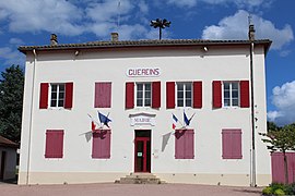 Town hall | |
Location of Guéreins  | |
 Guéreins | |
| Coordinates: 46°06′32″N 4°46′50″E / 46.1089°N 4.7806°ECoordinates: 46°06′32″N 4°46′50″E / 46.1089°N 4.7806°E | |
| Country | France |
| Region | Auvergne-Rhône-Alpes |
| Department | Ain |
| Arrondissement | Bourg-en-Bresse |
| Canton | Châtillon-sur-Chalaronne |
| Intercommunality | |
| Government | |
| • Mayor (2020–2026) | Claude Cleyet-Marrel[1] |
| Area 1 | 4.51 km2 (1.74 sq mi) |
| Population (Jan. 2018)[2] | 1,448 |
| • Density | 320/km2 (830/sq mi) |
| Time zone | UTC+01:00 (CET) |
| • Summer (DST) | UTC+02:00 (CEST) |
| INSEE/Postal code | 01183 /01090 |
| Elevation | 169–232 m (554–761 ft) |
| 1 French Land Register data, which excludes lakes, ponds, glaciers > 1 km2 (0.386 sq mi or 247 acres) and river estuaries. | |


Guéreins is a commune in the Ain department in eastern France.
Population[]
| Year | Pop. | ±% |
|---|---|---|
| 2006 | 1,184 | — |
| 2007 | 1,237 | +4.5% |
| 2008 | 1,241 | +0.3% |
| 2009 | 1,275 | +2.7% |
| 2010 | 1,308 | +2.6% |
| 2011 | 1,341 | +2.5% |
| 2012 | 1,388 | +3.5% |
| 2013 | 1,418 | +2.2% |
| 2014 | 1,423 | +0.4% |
| 2015 | 1,429 | +0.4% |
| 2016 | 1,435 | +0.4% |
Twin towns[]
Guéreins is twinned with Bottens in Switzerland.
See also[]
References[]
- ^ "Répertoire national des élus: les maires". data.gouv.fr, Plateforme ouverte des données publiques françaises (in French). 9 August 2021.
- ^ "Populations légales 2018". The National Institute of Statistics and Economic Studies. 28 December 2020.
| Wikimedia Commons has media related to Guéreins. |
This Ain geographical article is a stub. You can help Wikipedia by . |
Categories:
- Communes of Ain
- Ain geography stubs