Ben Avon
| Ben Avon | |
|---|---|
 | |
| Highest point | |
| Elevation | 1,171 m (3,842 ft)[1] |
| Prominence | c. 197 m (646 ft) |
| Parent peak | Beinn a' Bhùird |
| Listing | Munro, Marilyn |
| Coordinates | 57°05′56″N 3°26′09″W / 57.09894°N 3.43596°WCoordinates: 57°05′56″N 3°26′09″W / 57.09894°N 3.43596°W |
| Naming | |
| Native name | Beinn Athfhinn (Scottish Gaelic) |
| English translation | Hill of the bright one |
| Pronunciation | Scottish Gaelic: [peɲ ˈahɪɲ] |
| Geography | |
 Ben Avon | |
| OS grid | NJ131018 |
| Topo map | OS Landranger 36 |

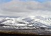
Ben Avon (Scottish Gaelic: Beinn Athfhinn) is a mountain in the Cairngorm mountains of Scotland. The highest point of the massif, known as Leabaidh an Dàimh Bhuidhe (bed of the yellow stag) is classified as both a Munro and a Marilyn.
Ben Avon is a very large and complex mountain sprawling over more than 30 km2 (12 sq mi). The summit plateau is dominated by granite tors, one of which forms the summit. From the broad summit plateau ridges lead in almost every direction, allowing access from Glen Avon to the north, from Beinn a' Bhùird to the west and from in the south. To the west of the summit lies the massive corrie, Slochd Mòr, with its rocky cliffs, and the approaches from the south and west take you close to the corrie rim.
The most common ascent route is via the path in the deep glen that separates Ben Avon and Beinn a' Bhùird, or from Beinn a' Bhùird itself. The summit tor itself must be climbed in order to "bag" the mountain, though it is an easy scramble.
References[]
- ^ "walkhighlands Ben Avon". walkhighlands.co.uk. 2013. Retrieved 30 November 2013.
| Wikimedia Commons has media related to Ben Avon. |
 |  | ||
| |||
- Munros
- Marilyns of Scotland
- Mountains and hills of the Cairngorms
- Mountains and hills of Moray
- Mountains and hills of Aberdeenshire
- One-thousanders of the British Isles