Cairn Gorm
| Cairn Gorm | |
|---|---|
| An Càrn Gorm | |
 Cairn Gorm from across Coire an t-Sneachda | |
| Highest point | |
| Elevation | 4,084 feet (1,245 m)[1] |
| Prominence | 478 ft (146 m) |
| Parent peak | Ben Macdui |
| Isolation | 2.78 miles (4.47 km) ( [2] |
| Listing | Munro |
| Naming | |
| English translation | The Blue Cairn or The Green Cairn[3] |
| Language of name | Scottish Gaelic |
| Pronunciation | Scottish Gaelic: [əŋ ˈkʰaːrˠn̪ˠ ˈkɔɾɔm] |
| Geography | |
| Location | Cairngorms, Scotland |
| OS grid | NJ005040 |
| Topo map | OS Landranger 36 |
| Climbing | |
| Easiest route | Hike |

| Listed summits of Cairn Gorm | ||||
| Name | Grid ref | Height | Status | |
|---|---|---|---|---|
| Cairn Lochan | NH985025 | 3,986 ft (1,215 m) | Munro Top | |
| Stob Coire an t-Sneachda | NH996029 | 3,858 ft (1,176 m) | Munro Top | |
| Cnap Coire na Spreidhe | NJ013049 | 3,773 ft (1,150 m) | Munro Top | |
| Creag an Leth-choin | NH968033 | 3,455 ft (1,053 m) | Munro Top | |
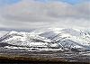
Cairn Gorm is a mountain and listed Munro in the Scottish Highlands. It is part of the Cairngorms range and wider Grampian Mountains. With a summit elevation of 4,084 ft (1,245 m) AMSL, Cairn Gorm is the seventh-highest mountain in the British Isles. The high, broad domed summit overlooking Strathspey is one of the most readily identifiable mountains from the nearby town and regional centre of Aviemore.
Since the 1960s over 600 hectares (1,500 acres) of the north-western slopes of the mountain in Coire Cas and Coire na Ciste have been developed for alpine skiing. The ski lift infrastructure includes a funicular railway in Coire Cas. The corrie south of Coire Cas, Coire an t-Sneachda, is separated from the ski area by a ridge known as Fiacaill a' Choire Chais. The southern slopes of Cairn Gorm overlook the remote Loch Avon (pronounced Loch A'an).
Etymology[]
The mountain shares its name with the wider Cairngorms mountain range and the Cairngorms National Park of which it is a part. This is despite that it is neither the highest nor the most prominent mountain in the range. The Cairngorms mountain range was historically known as Am Monadh Ruadh, a Scottish Gaelic name meaning The Red Hills. The Scottish Gaelic Gorm means "blue" in English; but when describing vegetation can mean "green" or "greening", so Cairn Gorm can mean either Blue Cairn or Green Cairn.[4]
Climate[]

Cairn Gorm has a tundra climate (Köppen ET). There is an automated weather station (AWS) controlled by Heriot-Watt University on the summit of the mountain[5] providing temperature and wind speed data. There is also a separate AWS run by the Met Office (synop code 03065) that publishes temperature and frost data. Cairn Gorm averages 194.4 frost days per annum, making it the coldest weather station in the United Kingdom.[6] Winter low temperatures are not extreme when compared with some other UK stations, but the severity of the climate is illustrated by its cool summers.
The highest temperature since 1985 is 25.5 °C (77.9 °F), recorded on 23 May 1989.[7] The coldest temperature is −26.9 °C (−16.4 °F) on 6 March 2007.[8] Daytime temperatures staying below 0 °C (32 °F) all day occur most frequently between October and May but have been observed during every month of the year. Daytime maximum temperatures below −10 °C (14 °F) and night-time temperature above 15 °C (59 °F) are uncommon. The lowest daytime maximum was −12.7 °C (9.1 °F) on 28 February 2018.[9] The Foehn wind can affect the mountain, particularly during late autumn and winter. This phenomenon presumably resulted in the November record high.[10]
The warmest month on record is July 2006, with a mean temperature of 9.9 °C (49.8 °F).[11] Conversely, the coldest month on record is March 2013, with a mean temperature of −6.7 °C (19.9 °F).[12]
| Climate data for Cairn Gorm Summit, Elevation: 1,245 m (4,085 ft), 1981–2010 | |||||||||||||
|---|---|---|---|---|---|---|---|---|---|---|---|---|---|
| Month | Jan | Feb | Mar | Apr | May | Jun | Jul | Aug | Sep | Oct | Nov | Dec | Year |
| Average high °C (°F) | −1.3 (29.7) |
−1.5 (29.3) |
−0.9 (30.4) |
1.5 (34.7) |
4.3 (39.7) |
7.1 (44.8) |
9.5 (49.1) |
9.2 (48.6) |
6.9 (44.4) |
3.9 (39.0) |
0.8 (33.4) |
−0.5 (31.1) |
3.3 (37.9) |
| Daily mean °C (°F) | −3.4 (25.9) |
−3.8 (25.2) |
−3.0 (26.6) |
−1.0 (30.2) |
1.7 (35.1) |
4.4 (39.9) |
6.9 (44.4) |
6.6 (43.9) |
4.5 (40.1) |
1.6 (34.9) |
−1.3 (29.7) |
−2.8 (27.0) |
0.9 (33.6) |
| Average low °C (°F) | −5.5 (22.1) |
−6.1 (21.0) |
−5.0 (23.0) |
−3.4 (25.9) |
−0.9 (30.4) |
1.7 (35.1) |
4.2 (39.6) |
3.9 (39.0) |
2.1 (35.8) |
−0.7 (30.7) |
−3.3 (26.1) |
−5.1 (22.8) |
−1.5 (29.3) |
| Average snowfall cm (inches) | 57 (22) |
62 (24) |
49 (19) |
43 (17) |
17 (6.7) |
3 (1.2) |
trace | 0 (0) |
trace | 9 (3.5) |
36 (14) |
47 (19) |
323 (126.4) |
| Average rainy days | 1.8 | 1.3 | 1.2 | 3.4 | 8.6 | 14.9 | 16.6 | 16.6 | 12.2 | 9.8 | 4.1 | 2.6 | 93.1 |
| Average snowy days | 15.6 | 15.5 | 14.7 | 13.1 | 8.2 | 2.6 | 0.2 | 0.0 | 0.8 | 4.8 | 11.2 | 14.0 | 100.7 |
| Source: Met Office,[13] Tutiempo.net,[14] and snowforecast.com [15] | |||||||||||||
Hiking and climbing[]
In clear, calm weather, the ascent of Cairn Gorm is a straightforward hike via the alpine ski area on the northern slopes. But when the mountain is stormbound, particularly in winter during blizzard and high avalanche risk conditions, any ascent or descent can be potentially lethal - particularly during white-outs when it is easy to lose one's bearings near the barren, featureless summit which is ringed in many directions by precipitous drops. In common with all the highest Cairngorm summits, ascents during winter conditions (which can and usually do extend well into springtime) will often require good navigation skills and winter climbing equipment such as crampons and ice-axes. The Windy Ridge path on Sròn an Aonaich lying to the northeast of Coire Cas is a steep and direct route, and is generally recommended by local Rangers, guides and guidebooks.[16] Another route to the summit is the access road up the centre of Coire Cas, however this route is a track used by the railway operator's vehicles, and gives an indirect route with several steep sections. It is not recommended as an ascent route, especially during the skiing season, though it gives good views of the Cairngorm Mountain Railway in its lower sections. Also in Coire Cas, Fiacaill a' Choire Chais offers a good walking route to Cairn Gorm and the adjacent plateau. A circuit of the cliff tops overlooking the Northern Corries of Cairn Gorm is highly recommended in many guide books and publications, giving one of the finest views in Scotland.[17] Walkers are advised to consult the local map[18] and call in at the Ranger Base at the car park.
There are many climbing routes at the head of Coire an t-Sneachda[19] and Coire an Lochain,[20] and in winter these corries form one of Scotland's major ice climbing areas.
1971 disaster[]
On 21–22 November 1971, five pupils from Ainslie Park High School in Edinburgh and a trainee instructor from Newcastle-under-Lyme died in a blizzard at Feith Buidhe on the Cairn Gorm plateau.[21] It stands as the UK's worst mountaineering disaster.[22]
Wildlife[]
The mountain is home to a number of bird species, including dotterel and ring ouzel (in the spring and summer) and snow bunting and ptarmigan (also known as rock ptarmigan) (all year round). Mammals inhabiting the mountain include mountain hare, red deer and a herd of reindeer. Wildflowers found on the mountain include dwarf cornel, cloudberry and butterwort. For many of these species of flora and fauna, Cairn Gorm is one of their key strongholds.[23]
Cairngorm Mountain ski resort[]
| Cairngorm Mountain | |
|---|---|
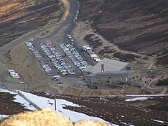 Cairngorm Mountain base station in June 2008 | |
| Location | Cairn Gorm, near Aviemore Highland, Scotland United Kingdom |
| Nearest major city | Inverness – 40 mi. (65 km) |
| Vertical | 1,607 ft (490 m) |
| Top elevation | 3,757 ft (1,145 m) |
| Base elevation | 2,150 ft (660 m) |
| Runs | 35
|
| Lift system | 13
|
| Snowmaking | 4 TechnoAlpin T40,
1 TechnoAlpin TF10, 8 TechnoAlpin TR8, 1 TechnoAlpin double decker Snow Factory |
| Night skiing | occasional |
| Website | CairnGorm Mountain |
History[]
The ski resort was developed on Cairn Gorm from 1960 onwards. A chairlift and chalet opened in December 1961.[24] It is the second largest in Scotland (after Glenshee). By the 1980s, thousands of skiers were using the resort on busy weekends, and the slopes could become very crowded.[25]
By the 2000s, the number of skiers at Cairngorm and Scotland's other ski areas had dropped, partly as a consequence of budget airline travel making access to the Alps easier.[26]
Snow conditions in the Scottish Highlands are unpredictable and Global Warming has emerged as a potential threat to the viability of the Scottish ski industry. In 2004, Adam Watson predicted that there would be no more than twenty years left for the industry.[27] However recent winters have had excellent snow cover and ski conditions and winter sports usage has recovered significantly resulting in improved finances.[28] In 2011–12 the resort trialled a TechnoAlpin T40 snow cannon, and in 2012–13 three more were leased.[29] A larger TF10 cannon was added for the 2013–14 season[30]
In April 2014 Natural Retreats was chosen by HIE as the new operator of Cairngorm Mountain Ltd.[31]
Funicular controversy[]
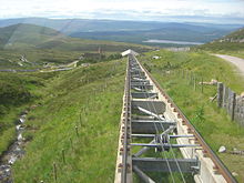
By 1990, much of the resort's original infrastructure was ageing and proving increasingly difficult to maintain. The chairlifts and tows were also susceptible to the high winds to which the mountain is prone, and were frequently forced to shut in winds above 25 mph (40 km/h). The Cairngorm Chairlift Company, who operated the resort, proposed removing the chairlift and replacing it with a funicular railway.
There was strong opposition to the funicular from environmental groups, who were concerned about damage to the mountain and its fragile soils and plants. The eventual compromise reached, after negotiations with Scottish Natural Heritage, allowed the Cairngorm Mountain Railway to be built, but with restrictions on its usage. Only those engaging in snow sports, or spectating, are allowed to exit from the top station. Other funicular users can visit the restaurant and visitor centre, but are currently restricted from leaving the building to start a walk. However, there are groups campaigning to remove this restriction.
Controversy mired the building project, with budget over-runs, allegations of conflicts of interest by those connected to both Highlands and Islands Enterprise and the construction company and questions raised about the use of public money. The construction was estimated to have cost around £19.6 million, mostly funded by Highlands and Islands Enterprise (HIE), a government body. £2.7 million was provided by the European Union.
The funicular opened in December 2001.[32] The railway provides access from the ski centre's day lodge base station at 2,150 ft (660 m) up the Coire Cas to the ski centre's Ptarmigan building at 3,566 ft (1,087 m) AMSL, a total distance of 6,460 ft (1.97 km). Thie Ptarmigan station is the highest elevation train terminal in the British Isles.

Cairn Gorm Locomotive[]
A locomotive operated by Caledonian Sleeper, a train operator that offers sleeper trains from London Euston to Scotland. The locomotive is the only Class 67 locomotive to be operated by Caledonian Sleeper. The locomotive is the subject of a Hornby model with TTS Sound in OO gauge.
References[]
- ^ "Cairn Gorm". Hill Bagging - the online version of the Database of British and Irish Hills (DoBIH). 2019. Retrieved 19 June 2019.
- ^ "Cairn Gorm isolation".
- ^ Dwelly, William Robertson, Michael Bauer, Edward. "Dwelly-d - Dwelly's Classic Scottish Gaelic Dictionary".
- ^ Dwelly, William Robertson, Michael Bauer, Edward. "Dwelly-d - Dwelly's Classic Scottish Gaelic Dictionary".
- ^ "Cairn Gorm Weather Station". Heriot-Watt University. Dept. of Physics. Retrieved 17 March 2008.
- ^ "Cairn Gorm Summit climate". Met Office. Retrieved 5 August 2015.
- ^ "Climate CAIRNGORM". en.tutiempo.net. Retrieved 9 October 2021.
- ^ "Climate CAIRNGORM". en.tutiempo.net. Retrieved 9 October 2021.
- ^ "Climate CAIRNGORM". en.tutiempo.net. Retrieved 9 October 2021.
- ^ "Climate CAIRNGORM". en.tutiempo.net. Retrieved 9 October 2021.
- ^ "Climate CAIRNGORM". en.tutiempo.net. Retrieved 9 October 2021.
- ^ "Climate CAIRNGORM". en.tutiempo.net. Retrieved 9 October 2021.
- ^ "Cairn Gorm Summit climate". Met Office. Retrieved 5 August 2015.
- ^ "Cairn Gorm Summit temperature records". Tutiempo.net. Retrieved 17 June 2019.
- ^ "Cairn Gorm Summit averages". Retrieved 9 January 2020.
- ^ "Cairn Gorm and the northern corries - Route Map".
- ^ Adam Watson. The Cairngorms, Scottish Mountaineering Trust
- ^ Ordnance Survey. 1:50,000 scale. Sheet 36. Grantown and Cairngorm.
- ^ "Coire an t'Sneachda".
- ^ "Coire an Lochain (Cairngorm)".
- ^ "Cairngorm Disaster 1971 - Scottish Saltire Branch - Aircrew Association". Archived from the original on 3 March 2016.
- ^ Cairngorm Mountain Rescue Association. 1988. Friends in High Places. ed Cliff, Peter.
- ^ See, for example, Lee Evans, Ultimate Site Guide to Scarcer British Birds (1996).
- ^ "End of the trudge up Cairngorm. Official Opening of Chair-lift". The Glasgow Herald. 25 December 1961. p. 8. Retrieved 4 June 2017.
- ^ "Cairngorm ski expansion starts Battle of Lurcher's Gully". The Glasgow Herald. 7 April 1980. p. 7. Retrieved 4 June 2017.
- ^ "Going downhill". The Scotsman. 12 December 2006. Retrieved 4 June 2017.
- ^ Seenan, Gerard (14 February 2004). "Global warming forces sale of Scottish winter sports resorts". The Guardian. Retrieved 4 June 2017.
- ^ Winterhighland Winterhighland. Retrieved 25 March 2021.
- ^ "Technoalpin continue business in Scotland " TechnoAlpin. Retrieved 1 December 2012.
- ^ "Key facts on the Cairngorm ski resort". The Scotsman. 1 December 2013. Retrieved 4 June 2017.
- ^ "CairnGorm Mountain's new operator confirmed as Natural Retreats UK". BBC News. 7 April 2014. Retrieved 24 April 2014.
- ^ Grant, Christine (24 December 2001). "Cairngorm funicular railway opens at last". The Scotsman. Retrieved 4 June 2017.
External links[]
- Computer generated summit panoramas North South here
- Cairn Gorm Weather Station
- CairnGorm Mountain Ltd.
Coordinates: 57°07′02″N 3°38′32″W / 57.1171°N 3.6423°W
 |  | ||
| |||
- Munros
- Mountains and hills of the Cairngorms
- Mountains and hills of Moray
- Mountains and hills of Highland (council area)
- Ski areas and resorts in Scotland
- Climbing areas of Scotland
- One-thousanders of the British Isles