Benguela Province
Benguela | |
|---|---|
Province | |
 | |
 Benguela, province of Angola | |
| Country | Angola |
| Capital | Benguela |
| Government | |
| • Governor | Rui Luís Falcão Pinto de Andrade |
| • Vice-Governor for the Political, Economic and Social Sector | Deolinda Tchocondoca Valiangula |
| • Vice-Governor for Technical Services and Infrastructures | Leopoldo Francisco Jeremias Muhongo |
| Area | |
| • Total | 39,826 km2 (15,377 sq mi) |
| Population (2014 census)[1] | |
| • Total | 2,231,385 |
| • Density | 56/km2 (150/sq mi) |
| ISO 3166 code | AO-BGU |
| HDI (2018) | 0.523[2] low · 12th |
| Website | www |
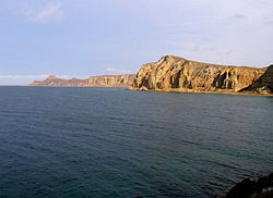
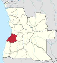
Benguela (Umbundu: Luombaka Volupale) is a province of Angola, situated in the west of the country. It lies on the Atlantic Ocean, and borders the provinces of Cuanza Sul, Namibe, Huila, and Huambo. The province has an area of 39,826 square kilometres (15,377 sq mi) and its capital is Benguela. According to the 2014 census, there were 2,231,385 inhabitants in the province.[1] The current governor of Benguela is Isaac dos Anjos.[3]
History[]
The Portuguese crown created the Kingdom of Benguela in 1615 to improve the conditions to develop the desired land route to Mozambique across Africa. The trading post founded here did not meet the expectations of the Portuguese in mineral resources and soil quality, so a village was only established for the slave trade, under the name of Mbaka.[4]

With the era of imperialist efforts of European countries to acquire colonies in Africa, at the end of the 19th century, Portugal increased its presence in the region in order to protect them from the advances of the German Empire and other states. Even before the Berlin Congo Conference in 1884–85, when European powers divided up the African colonial territories among themselves, Portugal had strengthened its colonial administration as early as 1869, and divided the three districts of Luanda, Benguela and Moçâmedes (now Namibe).[4] From 1903, the Benguela Railway was built connecting the port of Lobito to Belgian Congo, which led to the growing importance of the port and industries emerged, particularly the processing of sisal fiber, which contributed to the development of district of Benguela.[4][5] By 1912, the Benguela Railway had reached Huambo from Lobito, and the line was eventually completed in 1929.[4] Mostly after 1938, Benguela city's rubber and ivory trade made it a "relevant commercial warehouse".[6]
Since the 1960s, with increased competition in the sisal trade worldwide, rich fish stocks off the coast have been one of the principal economic drivers of the region.[5] From the late 1960s the population structure has changed, partly due to the regional economic upheaval, the massive emigration of European settlers to the Angola when it became independent in 1975, and the influx of many IDPs during the Angolan Civil War (1975–2002); 1988 figures put the displaced population in the province at 21,478, living in nine camps.[7]
Geography[]
Benguela Province is situated in the west of the country, on the Atlantic coast. It also borders the provinces of Cuanza Sul (to the north), Namibe (to the southwest), Huila (to the southeast), and Huambo (to the east). It is traversed by the northwesterly line of equal latitude and longitude with three zones: coastal at 0–500 metres (0–1,640 ft); central at 500–1,200 metres (1,600–3,900 ft); and eastern with a medium altitude greater than 1,500 metres (4,900 ft).[6]
Municipalities[]


The province of Benguela contains ten (10) municipalities (municípios):[8]
Communes[]
The province of Benguela contains the following communes (comunas); sorted by their respective municipalities:[9]
- Baia-Farta Municipality: – Baía-Farta, (Kalohanga), Dombe Grande,
- Balombo Municipality: – Balombo, Chindumbo (Chidumbo), Chingongo (Chigongo),
- Benguela Municipality: – Benguela; which is subdivided into six zones
- Bocoio Municipality: – Bocoio, , Chila, Cubal do Lumbo, , Passe
- Caimbambo Municipality: – , Caimbambo, , Catengue,
- Catumbela Municipality: – Biópio, Catumbela, ,
- Chongorói Municipality: – Bolongueira (Bolongueira), (Kamuine), Chongorói
- Cubal Municipality: – Capupa, Cubal, Iambala (Imbala), (Lomaum)
- Ganda Municipality: – Babaera, Casseque (Kasseque), Chicuma (Chikuma), Ebanga, Ganda
- Lobito Municipality: – , Egipto Praia (Egito), Lobito-Canata
Culture[]
The predominant ethnic groups are the Ovimbundu and Ngangela. The majority language is Umbundu.[6]
List of governors of Benguela[]
| Name | Years in office |
|---|---|
| Sócrates Mendonça de Oliveira Dáskalos * | (4) 1974–1977 |
| Estêvão Gungo Arão * | (2) 1976–1977 |
| José Ilídio Tehilekesse Manjenje * | (1) 1977 |
| Luís Doukui Paulo de Castro * | (1) 1977 |
| Garcia Lourenço Vaz Contreiras * | (3) 1977–1979 |
| Julião Mateus Paulo aka Dino Matross * | (3) 1979–1981 |
| Kundi Paihama * | (6) 1981–1986 |
| João Manuel Gonçalves Lourenço * | (4) 1986–1989 |
| Paulo Teixeira Jorge * | (7) 1989–1995 |
| Dumilde das Chagas Rangel | (15) 1995–2009 |
| Armando da Cruz Neto | (5) 2009–2013 |
| Isaac Francisco Maria dos Anjos | (5) 2013–2017 |
| Rui Luís Falcão Pinto de Andrade | (3) 2017– |
- Up to 1991, the official name was Provincial Commissioner
References[]
- ^ Jump up to: a b "Resultados Definitivos Recenseamento Geral da População e Habitação – 2014 Província de Benguela" (PDF). Instituto Nacional de Estatística, República de Angola. Retrieved 3 May 2020.
- ^ "Sub-national HDI - Area Database - Global Data Lab". hdi.globaldatalab.org. Retrieved 2020-02-27.
- ^ "Isaac dos Anjos hails provincial governors' capacity building". ANGOP. 28 July 2014. Retrieved 18 September 2014.
- ^ Jump up to: a b c d "História" (in Portuguese). Benguela.gov. Archived from the original on 7 March 2014. Retrieved 18 September 2014.
- ^ Jump up to: a b James, W. Martin (5 May 2011). Historical Dictionary of Angola. Scarecrow Press. p. 40. ISBN 978-0-8108-7458-9.
- ^ Jump up to: a b c "Benguela – The Province". ANGOP – Angola Press News Agency. Retrieved 20 September 2014.
- ^ Angola Company Laws and Regulations Handbook. Int'l Business Publications. 3 March 2008. p. 19. ISBN 978-1-4330-6936-9.
- ^ "Angola". Geohive.com. Archived from the original on 30 September 2016. Retrieved 18 September 2014.
- ^ Comunas - Ministério da Administração do Território
- ^ "Histórico dos Governadores" (in Portuguese). benguela.gov.ao. Retrieved 3 Mar 2019.
External links[]
 Media related to Benguela Province at Wikimedia Commons
- Official website of province governor
- Information on this province at the Angolan ministry for territorial administration
- Province geographical info at geoview.info
| show Provinces of Angola |
|---|
Coordinates: 12°40′S 14°1′E / 12.667°S 14.017°E

| show Authority control |
|---|
- Benguela Province
- Provinces of Angola