Beverloo Camp Railway
| Beverloo Camp Railway | |||||||||||||||||||||||||||||||||
|---|---|---|---|---|---|---|---|---|---|---|---|---|---|---|---|---|---|---|---|---|---|---|---|---|---|---|---|---|---|---|---|---|---|
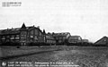
 Decauville railway station at Beverloo Camp, 1920s [1]  Route of the main line, as shown on a 1970s map | |||||||||||||||||||||||||||||||||
| Technical | |||||||||||||||||||||||||||||||||
| Line length | 115 km (71 mi) | ||||||||||||||||||||||||||||||||
| Track gauge | 600 mm (1 ft 11+5⁄8 in) | ||||||||||||||||||||||||||||||||
| |||||||||||||||||||||||||||||||||
The Beverloo Camp Railway was a 115 km (71 mi) long 600 mm (1 ft 11+5⁄8 in) gauge railway line in Beverloo Camp near Leopoldsburg in Belgium, which was operated from 1879 to 1940.[2][3]
History[]
The first section of track was laid in 1879 by Paul Decauville. It was extended to Leopoldsburg Station, on the standard gauge railway, in 1914.
The track was lifted on 10 May 1940 by Lieutenant Jeunehomme of the 3rd Compagnie and his troops, because of the German invasion during World War II.[4]
Route[]
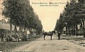
The network was in total 115 km long including all the tracks throughout old Beverloo Camp. They went to the barracks, but also to the buildings outside the Infantry or Cavalry Barracks (military bakery, military butchery, military hospital etc) and to the firing range, which was located several kilometers away from the barracks.

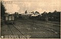
Military railway station

Military butchery
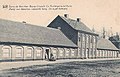
Military bakery

Actors and soldiers with a mock-up train, 1899[5]


Rolling stock[]
Carriages[]
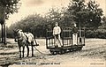
Initially horse-drawn, eight-wheeled Decauville bogie carriages were used.
Barracks
Transport services
Food transport

Steam locomotives[]
Later Borsig steam locomotives were used:
| Name | Type | Manufacturer | Operator | Image |
|---|---|---|---|---|
| Anna | 0-4-4-0 | Borsig | RCF | 
|
| Cecile | 0-4-4-0 | Borsig | RCF | 
|
| Henriette | 0-4-4-0 | Borsig | RCF | 
|
| 0-4-4-0 | Borsig | 
|
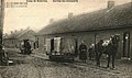
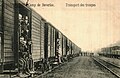
Troup transport[]

Troup transport
Embarkment of the troops
Military railway station

Embarkment of the troops
Troop transport


References[]
- ^ Joerg Seidel: Camp de Beverloo.
- ^ Patrick Marquenie: History: Evolution of the Cavalry Camp. Archived 6 August 2018 at the Wayback Machine
- ^ Roger Decoster: De Geschiedenis van het Kamp van Beverlo. Overzicht van het Ontstaan en Evolutie van het Kamp van Beverlo.
- ^ De Achttiendaagse Veldtocht. Het Belgische verhaal van mei 1940, eenheid per eenheid: Regiment Spoorwegtroepen.
- ^ Fotografie-Versorgungsmaterial-Zug. 1899-Militär, Komiker, Sepia. Lager von Beverloo. Leopoldsburg. Militärlager. Officier. Belgique.
External links[]
| Wikimedia Commons has media related to Beverloo Camp Railway. |
| Railways |
|
|---|---|
| Tramways |
|
| People | |
| Related | |
| |

- Decauville
- Railway lines in Belgium
- Railway lines opened in 1879
- Railway lines closed in 1940