Decauville railway Narès–Inglis–Topçin–Vatiluk
| Decauville railway Narès–Inglis–Topçin–Vatiluk | |||||||||||||||||||||||||||||||||||
|---|---|---|---|---|---|---|---|---|---|---|---|---|---|---|---|---|---|---|---|---|---|---|---|---|---|---|---|---|---|---|---|---|---|---|---|
 Bridge over the Vatiluk Gorge< | |||||||||||||||||||||||||||||||||||
| Technical | |||||||||||||||||||||||||||||||||||
| Line length | 30–35 km (19–22 mi) | ||||||||||||||||||||||||||||||||||
| Track gauge | 600 mm (1 ft 11+5⁄8 in) | ||||||||||||||||||||||||||||||||||
| |||||||||||||||||||||||||||||||||||

The Decauville railway Narès–Inglis–Topçin–Vatiluk was around 1916 a 30–35 km (19–22 mi) long narrow-gauge military railway near Thessaloniki in Greece with a gauge of 600 mm (1 ft 11+5⁄8 in)
Route[]
The 30–35 km (19–22 mi) long semicircular narrow gauge network with a track gauge of 600 mm (1 ft 11+5⁄8 in) from Narès (now Nea Filadelfeia, Νέα Φιλαδέλφεια) via Bumardza (now , Μπουγαρίεβο), Sari-Omer (Σαρή Ομέρ), Inglis (now , Αγχίαλος) and Topçin (now Gefyra, Γέφυρα) to Vatiluk (now Vathylakkos, Βαθύλακκος).[1]
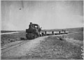
Near Topçin, June 1916

Inglis station
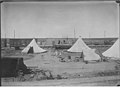
Tents
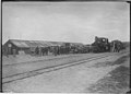
Station, Dec. 1916
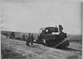
Decauville loco


References[]
- ^ Vatiluk (Kadikjöј). In: Military Mapping Survey of Austria-Hungary, around 1910.
| Wikimedia Commons has media related to Decauville railway Nares-Vatiluk. |
| Railways |
|
|---|---|
| Tramways |
|
| People | |
| Related | |
| |

Categories:
- Narrow gauge railways
- Rail transport in Greece
- Railway lines opened in 1916
- 600 mm gauge railways in Greece
- Decauville