Bhivpuri Road railway station
This article includes a list of general references, but it remains largely unverified because it lacks sufficient corresponding inline citations. (February 2019) |


Bhivpuri Road is a railway station on the Central line of the Mumbai Suburban Railway network in India. It is on the Karjat route. Neral is the previous stop and Karjat is the next stop.[1]
At Bhivpuri, a state highway connects to NH4, Panvel and Navi in one direction and to Badlapur and Thane District in the other. A new multi-facilities hospital at Bhivpuri, Raigad Hospital & Research Center, covers the area from Shelu and Neral to Karjat. There is also a waterfall which is popular for day trips.[2]
Gallery[]

Bhivpuri Road railway station
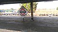
Bhivpuri Road railway station board

Bhivpuri Road railway station


References[]
| Wikimedia Commons has media related to Bhivpuri Road railway station. |
This article about a railway station in the Indian state of Maharashtra is a stub. You can help Wikipedia by . |
Categories:
- Railway stations in Raigad district
- Mumbai Suburban Railway stations
- Mumbai CR railway division
- Maharashtra railway station stubs