Raigad district
Raigad district | |
|---|---|
District of Maharashtra | |
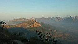 Hills around Raigad Fort | |
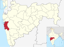 Location of Raigad district in Maharashtra | |
| Country | |
| State | Maharashtra |
| Division | Konkan |
| Headquarters | Alibag |
| Tehsils | 1. Alibag, 2. Panvel, 3. Murud, 4. Pen, 5. Uran, 6. Karjat, 7. Khalapur, 8. Mangaon, 9. Roha, 10. Sudhagad, 11.Tala, 12. Mahad, 13. Mhasala, 14. Shrivardhan, 15. Poladpur |
| Government | |
| • Body | Raigad Zilla Parishad Alibag |
| • Guardian Minister | Aditi Sunil Tatkare |
| • President Z. P. Raigad | Yogita Pardhi |
| • District Collector | Dr. Mahendra Kalyankar, IAS |
| • CEO Z. P. Raigad | Dr. Kiran Patil, IAS |
| • MPs | Sunil Tatkare (Raigad) [1] |
| Area | |
| • Total | 7,152 km2 (2,761 sq mi) |
| Population (2011) | |
| • Total | 2,634,200 |
| • Density | 370/km2 (950/sq mi) |
| • Urban | 36.91% |
| Demographics | |
| • Literacy | 92.33 |
| • Sex ratio | 975 per 1000 male |
| Time zone | UTC+05:30 (IST) |
| Major highways | NH-4, NH-17 |
| Average annual precipitation | 3,884 mm |
| Website | raigad |
Raigad District (Marathi pronunciation: [ɾaiɡəɖ]), previously known as Colaba District, is an district in the Konkan division of Maharashtra, India.[2] The district was renamed to Raigad after the fort that was the first capital of the former Maratha Empire, which in turn was renamed from its earlier name - Rairi. The fort is located in the interior regions of the district, in dense forests on a west-facing spur of the Western Ghats of Sahyadri Range. In 2011 the district had a population of 2,634,200, compared to 2,207,929 in 2001. The name was changed in the regime of Chief Minister A. R. Antulay on 1 January 1981.[3] In 2011 urban dwellers had increased to 36.91% from 24.22% in 2001.[4] Alibag is the headquarters of Raigad district.[5]
The district is bounded by Mumbai Harbour to the northwest, Thane district to the north, Pune district to the east, Ratnagiri district to the south and the Arabian Sea to the west. It includes the large natural harbour of Pen-Mandwa, which is immediately south of Mumbai harbour, and forming a single landform with it.
The northern part of the district is included in the planned metropolis of Navi Mumbai, consisting of Kharghar, Ulve node, New Panvel and Khanda Colony, Taloja, Kamothe and Kalamboli nodes as well as Uran City and its port, the JNPT.
The district includes cities/towns Kharghar, Taloja, Kalamboli, Panvel, Rasayani, Karjat, Khopoli, Matheran, Uran, Pen, Alibag, Murud-Janjira, Roha, Nagothane, Sudhagad-Pali, Mangaon, Mhasla, Shrivardhan, Mahad, Birwadi, Poladpur. The largest city in terms of Population, Industrialization as well as Area is Panvel. The district also includes the isle of Gharapuri or Elephanta, located in Uran which has ancient Hindu and Buddhist caves.
Kulaba (also spelled Kolaba) district was split from Thane district in 1869. A major part of the population being Hindus, Bhoir, Bhagat, Patil, Mhatre, Naik, Thakur, are famous and native surnames in Raigad district. At this point, the northernmost parts of modern Raigad district were retained in Thane district. Panvel, just across the bay from Mumbai, was not included in Kolaba district until 1883, and Karjat, an area in the north-east corner of modern Raigad district, was not placed in Kolaba district until 1891. Kolaba district was subsequently renamed Raigad district.
Officer[]
Members of Parliament[]
- Sunil Tatkare (NCP) - Raigad
- Shrirang Barne (Shiv Sena) - Maval
Raigad constituency is shared with Ratnagiri district while Maval constituency is shared with Pune district.
Guardian Minister[]
| Guardian Minister Raigad
पालकमंत्री रायगड | |
|---|---|
 Emblem of India | |
| Style | The Honourable |
| Residence | Roha Sunil Tatkare Home |
| Appointer | Chief Minister of Maharashtra |
| Term length | 5 years / No time limit |
| Website | raigad |
list of Guardian Minister[]
| Name | Term of office |
|---|---|
| Prakash Mehta | 31 October 2014 - 8 November 2019 |
| Aditi Sunil Tatkare | 09 January 2020 - Incumbent |
District Magistrate/Collector[]
| District Magistrate / Collector Raigad
जिल्हाधिका��ी तथा जिल्हदंडाधिकरी रायगड | |
|---|---|
Emblem of India | |
Incumbent Dr. Mahendra Kalyankar, IAS since 23 August 2021 | |
| Style | The Honourable |
| Residence | At Alibag Raigad district |
| Appointer | Government of Maharashtra |
| Term length | No time limit |
| Website | raigad |
list of District Magistrate / Collector[]
| Name | Term of office |
|---|---|
| Ms. Nidhi Chaudhary (IAS) | Till 21 August 2021 |
| Dr. Mahendra Kalyankar (IAS) | 23 August 2021 - Incumbent |
District Justice[]
| District Justice Raigad
जिल्हा न्यायाधीश रायगड | |
|---|---|
Emblem of India | |
Incumbent Shri. P.C. Bavaskar since 12 January 2019 | |
| Style | The Honourable |
| Residence | Alibag Raigad district |
| Appointer | Government of Maharashtra |
| Term length | No time limit |
| Website | raigad |
list of District Justice[]
| Name | Term of office |
|---|---|
| Shri. P.C. Bavaskar | 12 January 2019 - Incumbent |
District Police Commissioner[]
| District Police Commissioner
जिल्हा पोलीस आयुक्त | |
|---|---|
Emblem of India | |
Incumbent Shri. Ashok T. Dudhe (IPS) since 09 October 2020 | |
| Style | The Honourable |
| Residence | Alibag Raigad district |
| Appointer | Government of Maharashtra |
| Term length | No time limit |
| Website | raigad |
list of District Police Commissioner[]
| Name | Term of office |
|---|---|
| Shri. Ashok T. Dudhe (IPS) | 09 October 2020 - Incumbent |
President & Vice-President Zilla Parishad[]
- President - Miss. Yogita Pardhi
- Vice-President - Mr. Sudhakar Ghare
Chief Executive Officer Zilla Parishad[]
- Dr. Kiran Patil (IAS)
Sub-Divisional Officer[]
01) Alibaug
02) pen
03) Panvel
04) Karjat
05) Roha
06) Mangaon
07) Shrivardhan
08) Mahad
Tahasildar & Executive Magistrate[]
- Alibag - Mr. Sachin Shezaal
- Karjat - Mr. Vikram Deshamukh
- Khalapur - Mr. Iresh Chapalwar
- Mahad - Mr. Suresh Kashid
- Mangaon - Mrs. Priyanka Aayre-Kamble
- Mhasala
- Murud
- Panvel
- Pen - Mrs. Aruna Jadhav
- Poladpur
- Roha
- Shrivardhan - Mr. Gosavi
- Sudhagad Pali
- Tala
- Uran
Education[]
After the British took over the old Colaba and this region, they established four Anglo-Vernacular medium school and 30 government schools in the year 1865–66. In the year 1861 the first school for girls was started in Alibag. The Mission Church started the first English school in Alibag in 1879. Prabhakar Patil Education Society (PNP education Society) runs 27 Institutes: Five Primary English & Marathi Schools, Twenty Seven Secondary Marathi Schools, One Arts, Science & Commerce Jr. & Sr. College, One English & Marathi Medium D. Ed College, One B. Ed. College, One Polytechnic Institute and One MMS College. Securities and Exchange Board of India (SEBI) established National Institute of Securities Markets at Patalganga, tal Khalapur. Two more old and valuable institutions in Raigad District named Vasantrao Naik College Murud And Mhasla, established by the former Chief Minister of Maharashtra A. R. Antulay
Administrative subdivisions[]
Raigad district is divided into four subdivisions, with fifteen talukas, and 1,967 villages.[6]
| Subdivision | Taluka | km2 | Census 2001 | Census 2011 | Panchayats[7] | Villages |
|---|---|---|---|---|---|---|
| Alibag | Alibag | 500 | 221,661 | 236,167 | 62 | 218 |
| Murud | 231 | 72,046 | 74,207 | 24 | 74 | |
| Pen | Pen | 499 | 176,681 | 195,454 | 63 | 171 |
| Panvel | Panvel | 631 | 422,522 | 750,236 | 90 | 177 |
| Uran | 184 | 140,351 | 160,303 | 34 | 62 | |
| Karjat | Karjat | 665 | 184,420 | 212,051 | 50 | 184 |
| Khalapur | 183 | 183,604 | 207,464 | 42 | 141 | |
| Roha | Roha | 643 | 161,750 | 167,110 | 62 | 162 |
| Sudhagad | 467 | 62,852 | 62,380 | 34 | 98 | |
| Mangaon | Mangaon | 683 | 152,270 | 159,613 | 74 | 187 |
| Tala | 250 | 42,869 | 40,619 | 26 | 61 | |
| Shrivardhan | Shrivardhan | 120 | 85,071 | 83,027 | 43 | 78 |
| Mhasla | 236 | 61,010 | 59,914 | 40 | 84 | |
| Mahad | Mahad | 1,257 | 186,521 | 180,191 | 134 | 183 |
| Poladpur | 373 | 54,301 | 45,464 | 43 | 87 | |
| Total | 15 | 7,152 | 2,207,929 | 2,634,200 | 821 | 1,967 |
Municipal Civic Bodies in Raigad District[]
Municipal Corporations[]
- Panvel (in Navi Mumbai city)
SPAs[]
Special Planning Authorities operational in Raigad district are
- MMRDA
- CIDCO
- NAINA
Municipal Councils[]
Nagar Panchayats[]
Proposed Municipal Councils[]
- Pali-Sudhagad
- Tala
- Mhasla
- Poladpur
Demographics[]
| Year | Pop. | ±% p.a. |
|---|---|---|
| 1901 | 721,083 | — |
| 1911 | 714,371 | −0.09% |
| 1921 | 677,586 | −0.53% |
| 1931 | 756,315 | +1.11% |
| 1941 | 805,157 | +0.63% |
| 1951 | 909,083 | +1.22% |
| 1961 | 1,058,855 | +1.54% |
| 1971 | 1,263,003 | +1.78% |
| 1981 | 1,486,452 | +1.64% |
| 1991 | 1,824,816 | +2.07% |
| 2001 | 2,207,929 | +1.92% |
| 2011 | 2,634,200 | +1.78% |
| source:[8] | ||
According to the 2011 census Raigad district has a population of 2,634,200,[9] roughly equal to the nation of Kuwait[10] or the US state of Nevada.[11] This gives it a ranking of 153rd in India (out of a total of 640).[9] The district has a population density of 368 inhabitants per square kilometre (950/sq mi) .[9] Its population growth rate over the decade 2001-2011 was 19.31%.[9] Raigad has a sex ratio of 959 females for every 1000 males,[9] and a literacy rate of 83.14%.[9]
At the time of the 2011 Census of India, 79.04% of the population in the district spoke Marathi, 7.06% Hindi and 4.85% Urdu as their first language.[13]
Scheduled Castes and Scheduled Tribes are 5.12% and 11.58% of the population respectively. The most populous tribes are the Katkari, Thakar and Mahadev Koli.[14]
Transport[]
Raigad District is connected to Mumbai by Sion Panvel Expressway. The Mumbai-Pune expressway and NH4 passes through Panvel. NH 66, which starts at Panvel, traverses the whole district. The Konkan Railway line starts at Roha and passes through Mangaon and Veer in Mahad. The Central Railway Line of Mumbai to Pune passes through Karjat with Extension Line for Karjat to Khopoli. Panvel Junction is the most important railway station in the district; it is connected to Mumbai (by both the Harbour Line and Main Line of Central Railway), Thane (by Trans-Harbour Line), Roha, Vasai (Western Railway) and Karjat. All trains, ranging from passengers to Rajdhanis stop here, and it is considered the gateway for travelling south. There is a narrow gauge railroad from Neral to Matheran, called the Matheran Hill Railway. The main ports are JNPT, Mandava, Revas, Murud, Dighi and Shrivardhan .
University[]
- Dr. Babasaheb Ambedkar Technological University is a unitary, autonomous university located at Lonere in Raigad district, established in 1989 under the Government of Maharashtra Act 1983.[15]
References[]
- ^ Election Commission website
- ^ "List of districts in Maharashtra". districts.nic.in. Retrieved 19 November 2012.
- ^ रायगड जिल्हा
- ^ "Raigarh District Population 2011". Census Organisation of India.
- ^ "District Map". Government of Maharashtra. Retrieved 7 January 2021.
- ^ "District details". Raigad District, Maharashtra State.
- ^ "Block Panchayats of Raigad, Maharashtra". National Panchayat Directory, Panchayat Informatics Division, National Informatics Centre, Government of India. Archived from the original on 5 November 2011.
- ^ Decadal Variation In Population Since 1901
- ^ Jump up to: a b c d e f "District Census 2011". Census2011.co.in. 2011. Retrieved 30 September 2011.
- ^ US Directorate of Intelligence. "Country Comparison:Population". Retrieved 1 October 2011.
Kuwait 2,595,62
- ^ "2010 Resident Population Data". U. S. Census Bureau. Archived from the original on 19 October 2013. Retrieved 30 September 2011.
Nevada 2,700,551
- ^ "C-16 Population By Religion - Maharashtra". census.gov.in.
- ^ 2011 Census of India, Population By Mother Tongue
- ^ 2008 Revised Gazetteer of Raigad
- ^ "University Grant Commission". Retrieved 19 November 2012.
External links[]
| Wikimedia Commons has media related to Raigad district. |
| show Places adjacent to Raigad district |
|---|
| show |
|---|

| show Authority control |
|---|
Coordinates: 18°39′00″N 72°52′48″E / 18.65000°N 72.88000°E

- Raigad district
- 1869 establishments in India
- Districts of Maharashtra
- Konkan division