
Konkan
This article needs additional citations for verification. (April 2015) |
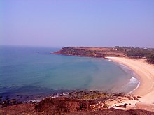
Konkan is the rugged section of the mid-western coast of India, the coastal hinterland of Konkan consists of numerous riverine islands, river valleys, and the hilly slopes of the Western Ghats, that lead up into the tablelands of the Deccan. Geographically, Konkan is bound by the Arabian Sea to the west, and the Deccan Plateau to the east. The coast of Konkan proceeds from the north at Damaon in the Gulf of Cambay, extends southwards all along the western seaside areas of Maharashtra and Goa, and meets the Canara coast at the northern edge of Carwar district in Karnataka.
The best-known islands of Konkan are Ilhas de Goa, the location of the capital city of Panjim, and the seven islands of Bombay on which sits Bombay (Mumbai), the capital of Maharashtra.
Definition[]
Geographically, the stretch of land from the Daman Ganga River in the north to the Gangavalli River in the south is considered to form the Konkan.[1]
The ancient Sapta Konkan was a larger geographical area that extended from Gujarat to Kerala.[2] The whole region of coastal Maharashtra and coastal Karnataka is included within the Konkan.
However, this segment overlaps the Konkan and Malabar coast continuum; and usually corresponds to the southernmost and northernmost stretches of these locales respectively.
Etymology[]

According to the Sahyadrikhanda of the Skanda Purana, Parashurama threw his axe into the sea and commanded the Sea God to recede up to the point where his axe landed. The new piece of land thus recovered came to be known as Saptah-Konkana, meaning "piece of earth", "corner of earth", or "piece of corner", derived from Sanskrit words: koṇa (कोण, corner) + kaṇa (कण, piece).[3][4] Xuanzang, the noted Chinese Buddhist monk, mentioned this region in his book as Konkana Desha; Varahamihira's Brihat-Samhita described Konkan as a region of India; and 15th century author Ratnakosh mentioned the word Konkandesha.[5]
Geography[]
Konkan extends throughout the western coasts of Maharashtra, Goa and Karnataka.[5] It is bounded by the Western Ghats mountain range (also known as Sahyadri) in the east, the Arabian Sea in the west, the Daman Ganga River in the north and the River Aghanashini in the south.
The Gangavalli flows in the district of Uttara Kannada in present-day Karnataka. Its northern bank constitutes the southernmost portion of Konkan. The towns of Karwar, Ankola, Kumta, Honavar and Bhatkal fall within the Konkan coast.

The largest city on the Konkan coast is Mumbai, the state capital of Maharashtra. The others are, from north to south:[6]
- Palghar district
- Thane district
- Mumbai Suburban district
- Mumbai City district
- Raigad district
- Ratnagiri district
- Sindhudurg district
- Goa
- Karwar
- Uttara Kannada
Ethnology[]
The main ethnolinguistic group of the Konkan region is the Konkani people.
Specific caste and communities found in the region are the Aagri, Koli, Kunbi, Bhandari, Maratha, Kharvi, Mangela, Karadi, Phudagi, Vaiti, Mahar, Chambhar, Kumbhar, Dhobi, Teli, Nhavi, Kasar, Sutar, Lohar, Gabit, Padti, Dhangar, Gaud Saraswat Brahmin (also includes Rajapur Saraswats and Chitrapur Saraswats), Daivajna, Kudaldeshkar, Pathare Prabhu, Gomantak Maratha, Chitpawan, Karhade, Kayastha Prabhu, Somvanshi Kshatriya Pathare, Vaishya Vani, Vadval, Komarpant, Gavli, Ghorpi, Nath Jogi, Gurav, Ghadi, Namdev Shimpi and others. Billava, Bunt and Linghayat communities found in the parts of Karnataka which are near to Konkan.
Tribal communities include the Katkari, Thakar, Konkana, Warli and Mahadev Koli, mainly found in the northern and central parts of Konkan. The Dubla and Dhodia tribes in southern Gujarat, Dadra and Nagar Haveli, and Palghar district of Maharashtra are also part if Konkan. Palghar district has the largest percentage of tribal population in Konkan. A small nomadic tribe called the Vanarmare is found in southern parts of Konkan, which was originally associated with the hunting of monkeys. The Gauda and Velip tribes are found in Goa.
The Jewish community called Bene Israel is mainly found in Raigad district. The Christians included East Indians in North Konkan and Mumbai, Goan Catholics in Goa, Karwari Catholics in Uttara Kannada as well as Mangalorean Catholics in Udupi and Dakshina Kannada. Minorities of Muslim communities like Konkani Muslims and Nawayaths are scattered throughout the region.
See also[]
- Coast of India
- People of the Konkan Division
- Konkani people
- Konkani language
- Konkan Railway
- Jaitapur Nuclear Power Project
- Malabar Coast
- Coromandel Coast
References[]
- ^ Bhandare, Vasant Ramchandra (1985). Maharashtra-Karnataka Border Dispute: Politics of Manipulation. Kirti Prakashan.
- ^ Saradesāya, Manohararāya (2000) "The Land, the People, and the Language". A History of Konkani Literature: From 1500 to 1992. Sahitya Akademi. pp. 1–14. ISBN 9788172016647.
- ^ Shastri Gaytonde, Gajanan (ed.). Shree Scanda Puran (Sayadri Khandha) (in Marathi). Mumbai: Shree Katyani Publication.
- ^ Satoskar, B. D. Gomantak Prakruti ani Sanskruti. Part 1 (in Marathi). Shubhada Publication. p. 206.
- ^ a b Saradesāya, Manohararāya (2000). "The Land, the People and the Language". A History of Konkani Literature: From 1500 to 1992. Sahitya Akademi. pp. 1–14. ISBN 8172016646.
- ^ Limited, Nigade Software Technologies (opc) Private. "Konkan Division District List (कोंकण विभाग जिल्हा यादी)". www.swapp.co.in. Retrieved 26 January 2022.
External links[]
 Konkan travel guide from Wikivoyage
- Konkan Tourism - A Complete Guide on Tourism
- Konkan Hotels
- Tourist Place to visit Konkan Darshan
Capital: Mumbai Second capital: Nagpur | |||||||||||||
| Topics |
| ||||||||||||
| Regions |
| ||||||||||||
| Divisions and Districts |
| ||||||||||||
| Million-plus cities in Maharashtra |
| ||||||||||||
| Other cities with municipal corporations |
| ||||||||||||
Portal:India | |||||||||||||
- Konkan
- Regions of India
- Landforms of Goa
- Coasts of India
- Konkani