Palakkad Gap
| Palakkad Gap | |
|---|---|
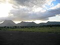
 Panorama view of Palakkad from Tamilnadu side | |
| Elevation | 140 metres (460 ft) |
| Location | Tamil Nadu - Kerala , India |
| Range | Western Ghats |
| Coordinates | 10°43′07″N 76°52′55″E / 10.718550°N 76.881966°ECoordinates: 10°43′07″N 76°52′55″E / 10.718550°N 76.881966°E |
 | |


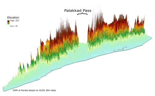
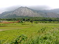
Palakkad Gap or Palghat Gap is a low mountain pass in the Western Ghats between Coimbatore in Tamil Nadu and Palakkad in Kerala. It has an average elevation of 140 metres (460 ft) with a width of 24–30 kilometres (15–19 mi). The pass is located between the Nilgiri Hills to the north and Anaimalai Hills to the south.[1]
Origin and history[]

There are various theories about the origin of Palakkad gap. One among them is that it is caused by the landslide due to rivers flowing in opposite directions. The Bharathappuzha river (River Ponnani) originates in the Palakkad Gap from rivulets and tributaries feeding from steep escarpment slopes along the flanks of the Ghats.[2]
Palakkad gap has played a major role in enabling human migration into Kerala from parts of Tamil Nadu. From 300 B.C. to 13th century, it also helped the Cheras rule the entire Kerala and the Kongu Nadu as one geographical unit from Karur in Western Tamil Nadu. Tamil Brahmins migrated to Palakkad from Central Tamil Nadu via the Palakkad gap from the 15th century to 18th century.[3]
Effect on weather[]
The gap affects the weather patterns in Southern India as it allows the moisture-laden Southwest monsoon winds into western Tamil Nadu, moderating summer temperatures and generating greater rainfall in the region relative to the rest of lowland Tamil Nadu. It affects rainfall activity in parts of tamilnadu likely Coimbatore,palladam, kangeyam, dharapuram, udumalai .It also allows the hot winds coming from Tamil Nadu which warm the eastern part of Kerala compared to the rest of the state and the tropical cyclone winds from Bay of Bengal bearing rain during the summer.[citation needed]
Transport and trade[]
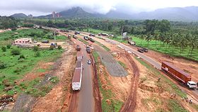
The gap is the lowest pass through the Western Ghats in the region. It is an important mountain pass in the Western Ghats that runs along the entire eastern edge of Kerala isolating it from the neighboring Tamil Nadu. It acts as an important transport corridor between the two States by linking Palakkad District of Kerala with Coimbatore District of Tamil Nadu and has served as a vital trade route between the east and west coasts of peninsular India since ancient times.
Both the National Highway 544 and the Coimbatore - Shoranur railway line , Palakkad - Pollachi Railway line joining Kerala to Tamil Nadu pass through the gap. The gap also helps for VHF line of sight communications between the states of Kerala and Tamil Nadu.
Wind Energy[]
The Palakkad Gap funnels the winds blowing from the west on to Palakkad District district in Kerala , Coimbatore and Tirupur districts in Tamil Nadu making the region one of the major wind power generation areas.[4] The average annual wind speed is 18–22 km/hr.[5] Large windmill farms can be seen in and around Kanjikode, Chittur, Muthalamada, Kollengode, Udumalaipettai and Madathukulam.
See also[]
- Aryankavu mountain pass.
- Aralvaimozhi
Gallery[]

Palghat Gap as seen from Coimbatore-Shoranur railway line
Palghat Gap as seen from Palghat-Chitoor Road

Western Ghats as seen from Coimbatore-Shoranur rail line
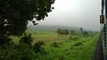
View of Ghats

Palghat-Coimbatore NH 47 runs through the gap

Southern end of the gap

One end of the gap
A passenger train in Palghat gap


References[]
- ^ "Britannica Encyclopedia". Retrieved 8 March 2015.
- ^ Nair, Dr. S. Sathis Chandran, (20 May 2004). A Note on the Ecological Impact of the Proposed Pathrakkadavu Hydro-Electric Project (PHEP) in the Kunthi River, Palakkad District of Kerala: India - Silent Valley Rainforest Under Threat Once More
- ^ "History of Kerala Iyers,migration of Tamil Brahmins to Kerala". www.kuzhalmannamagraharam.info. Retrieved 9 September 2020.
- ^ "Tiruppur District Official Webpage". Retrieved 6 November 2013.
- ^ "TamilNadu Energy Development Agency". Archived from the original on 7 November 2013. Retrieved 6 November 2013.
External links[]
| Wikimedia Commons has media related to Palakkad Gap. |
- View of Palghat Gap from the Nelliampathy Mountain ranges
- Mountain passes of the Western Ghats
- Geography of Palakkad district
- Tourist attractions in Palakkad district
- Mountain passes of Kerala
- Transport in Palakkad district