Pensi La
| Pensi La | |
|---|---|
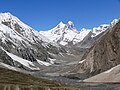
 Drang Drung glacier seen from the Pensi La pass | |
| Elevation | 4,400 m (14,436 ft) |
| Location | Ladakh, India |
| Range | Himalaya |
| Coordinates | 33°52′18″N 76°20′57″E / 33.871554°N 76.34907°E |
 Pensi La Location in Ladakh | |


Pensi-la (Pensi Pass) is a mountain pass in the Ladakh union territory of India, which is known as the Gateway to Zanskar. Pensi La is 4,400 m (14,436 ft) above sea level and connects the Suru Valley region to the Zanskar Valley region. The summit at this end of the Suru Valley, the only peak which can be seen, is 7,012 m (23,005 ft) high, while the mountain to the north is 6,873 m (22,549 ft). The pass is about 25 km from Rangdum Monastery.[1]

To the west of Pensi La watershed flows the Suru River, an important tributary of the Indus which meets at Kargil. The Drang Drung Glacier to the eastern flank of Pensi La is the source of Stod or Doda River which flows into the Padum Valley, and joins with Tsarap Chu to form the mighty Zanskar River.
"The descent from the Pensi La into the Stod Valley [in Zanskar] is steeper than the climb up from Rangdum Gompa, but not too difficult. The road winds about with many hairpin turns, which can be cut across on foot, to the river below. Wild rhubarb can be seen growing on the slopes. The generally used trekking route follows the road on the left bank of the Stod (or Doda). . . . The grass at the foot of the Pensi La furnishes a good pasturage and this is a fine camping spot."[2]
. Pensi-La is also the gateway to the Padum, the headquarters of Zanskar sub-division of Kargil district. A 240 km road connecting Kargil town to Padum, through the Pensi La remains open for a brief 5 months, between May and October.[citation needed]
Before the modern road was built, the pass, apparently, used to be open only three months of the year because of heavy snows.[3]

View of Glacial lake and the Drang Drung Glacier, as seen from Pensi La, Zanskar, Ladakh, India.
Pensi La Peak - Source of Stod River


Coordinates: 33°51′N 76°22′E / 33.850°N 76.367°E
Footnotes[]
References[]
| Wikimedia Commons has media related to Pensi La. |
- Janet Rizvi. (1996). Ladakh: Crossroads of High Asia. Second Edition. Oxford University Press, Delhi. ISBN 0-19-564546-4.
- Schettler, Margaret & Rolf (1981). Kashmir, Ladakh & Zanskar. Lonely Planet Publications. South Yarra, Victoria, Australia. ISBN 0-908086-21-0.
| show |
|---|
This Ladakh, India location article is a stub. You can help Wikipedia by . |
- Mountain passes of Ladakh
- Geography of Ladakh
- Ladakh stubs
- India geography stubs