Aurangabad division
Aurangabad division | |
|---|---|
Administrative Division | |
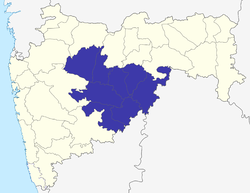 Location of Marathwada in Maharashtra | |
| Coordinates: 19°53′19.63″N 75°20′36.37″E / 19.8887861°N 75.3434361°ECoordinates: 19°53′19.63″N 75°20′36.37″E / 19.8887861°N 75.3434361°E | |
| Country | India |
| State | Maharashtra |
| Districts | 1. Aurangabad, 2. Nanded, 3. Jalna, 4. Osmanabad, 5. Latur, 6. Beed, 7.Parbhani, 8.Hingoli |
| Area | |
| • Total | 64,590.58 km2 (24,938.56 sq mi) |
| Population (2011)[1] | |
| • Total | 18,731,872 |
| Literacy | 76.49%[1] |
| Languages | |

Aurangabad division is one of the six administrative divisions of Maharashtra state in India. It lies in the Marathwada region of Maharashtra.
Districts[]
- Aurangabad
- Beed
- Jalna
- Latur
- Hingoli
- Parbhani
- Osmanabad
- Nanded
References[]
- ^ a b c "District wise Demography". Census 2011. Retrieved 23 May 2015.
| Topics | |||||||||||||
|---|---|---|---|---|---|---|---|---|---|---|---|---|---|
| Regions | |||||||||||||
| Divisions and Districts |
| ||||||||||||
| Million-plus cities in Maharashtra | |||||||||||||
| Other cities with municipal corporations | |||||||||||||
Portal:India | |||||||||||||
This article about a location in the Indian state of Maharashtra is a stub. You can help Wikipedia by . |
Categories:
- Aurangabad division
- Divisions of Maharashtra
- Marathwada
- Hyderabad State
- Maharashtra geography stubs
- Aurangabad Division geography stubs