Sindhudurg district
This article needs additional citations for verification. (June 2015) |
Sindhudurg District | |
|---|---|
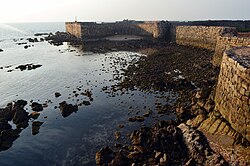 Sindhudurg fort | |
 Location of Sindhudurg district in Maharashtra | |
| Country | |
| State | Maharashtra |
| Division | Konkan |
| Headquarters | Oros, Sindhudurg |
| Talukas | 1. Dodamarg, 2. Sawantwadi, 3. Vengurla, 4. Kudal, 5. Malvan, 6. Kankavli, 7. Devgad, 8. Vaibhavwadi |
| Government | |
| • Lok Sabha constituencies | 1. Ratnagiri-Sindhudurg (shared with Ratnagiri district) (Based on Election Commission website) |
| • Vidhan Sabha constituencies | 3 |
| Area | |
| • Total | 5,207 km2 (2,010 sq mi) |
| Population (2011) | |
| • Total | 849,651 |
| • Density | 160/km2 (420/sq mi) |
| • Urban | 12.59% |
| Demographics | |
| • Literacy | 85.56% |
| • Sex ratio | 1,036 |
| Time zone | UTC+05:30 (IST) |
| Major highways | NH-66 |
| Average annual precipitation | 3,287 mm |
| Website | sindhudurg |


Sindhudurg (Marathi pronunciation: [sin̪d̪ʱud̪uɾɡ]) is an administrative district in the state of Maharashtra in India, which was carved out of the erstwhile Ratnagiri district. The district headquarters are located at Oros. The district occupies an area of 5,207 km2 and has a population of 849,651 of which 12.59% were urban (as of 2011).[1] As of 2011 it is the least populous district of Maharashtra (out of 36).[2]
History[]
The word 'Konkan' is of Indian origin and of considerable antiquity, though the origin of the name has never been sufficiently explained. The seven kingdoms of the Konkan of mythology are mentioned in the History of Kashmir and are said to have included nearly the whole west coast of India. The Pandavas are said to have passed through this region in the 13th year of their exile and had settled in this area for some time. The Raja of this region Veerat Ray had accompanied them in the war at Kurukshetra with the Kauravas.
In the second century A.D. the Maurya Empire annexed the Konkan coast. In the middle of the sixth century, kings of the Maurya and Nala dynasties appear to have been ruling in the Konkan. The district of Ratnagiri was under the Silahars and the capital of their kingdom was probably Goa and later it may have been transferred to a more central place in the vicinity of Ratnagiri or Kharepatan. Chandrapur was one of the most ancient towns in Konkan, probably founded by Chandraditya, son of the Chalukya king Pulakeshin II.
The 16th century saw the advent and rise of Portuguese power on the west coast of India and Sindhudurg was no exception. The sultan lost hold on the district in 1675 with the rise of Shivaji leading finally into the hands of Marathas. Marathas continued to the district till 1817 i.e. when the struggle between the British and the Peshvas came to an end and the whole of Konkan was transferred to the British.
In 1819 South Konkan was formed as separate district with its headquarters first at Bankot and later at Ratnagiri. Three northern subdivisions were transferred to Thane District in 1830 and the district was reduced to a sub-collectorate level under Thane district. In 1832, it was again made a full-fledged district and named as Ratnagiri district. In the year 1945, a new mahal (tahsil) called Kankavli Mahal (tahsil) was formed. The former Indian state of Sawantwadi was merged with the district and the taluka boundaries were reorganized in the year 1949. In the same year the new taluka of the Sawantwadi was created and two new mahals namely Kudal and Lanja were formed. With the reorganization of the states in 1956, the district was included in the Bombay state and since 1960, it forms a part of Maharashtra.The name of the district has been adopted from the sea fort of Sindhudurg. This was built by Shivaji Maharaj near Malwan and its name literally means ‘Sea Fort’. Its construction started on 25 November 1664 and after 3 years it was completed in such a fashion that it could not be seen easily by enemies coming from the Arabian Sea.
Sindhudurg district is the southern part of the Konkan coast which is historically known for its long coast line and safe harbors. Sindhudurg district was earlier a part of Ratnagiri district. For administrative convenience and industrial and agricultural development, Ratnagiri district was divided into Ratnagiri and Sindhudurg with effect from 1 May 1981. Sindhudurg district now comprises the eight tahsils of Sawantwadi, Kudal, Vengurla, Malvan, Devgad, Kankavli, Vaibhavwadi and Dodamarg.
About the district[]
Established on 1 May 1981,
Tehsils and Panchayat Samiti:
- Dodamarg
- Sawantwadi
- Kudal
- Vengurla
- Malvan
- Kankavli
- Devgad
- Vaibhavwadi
Nagar Palika:
- Dodamarg
- kudal
- Sawantwadi
- Malvan
- Kankavli
- Vengurla
Cities:
Smaller towns include :
- Dodamarg
- Vaibhavwadi
- Vijaydurg
- Amboli
- Rameshwar
- Girye
- Mangaon
- Shiroda
- Mhapan
- Talere
- Shirgaon
- Naringre
- Kharepatan
- Achara
- Sukalwad
- Khotale
- Hedul
- vanygawde
- Kasal
- pawashi
- Kadawal
- Trimbak
- Masure
- Bandiwade,(बांदिवडे) Malvan
- Jamsande
- Shiroda
- Ghonsari
- Hivale
- Poip
- Tirlot
- Navanagar
- Amberi
- Waghotan
- Tirawade
- Redi
- Talvade Gate
- Tale Bazar
- Salgaon
- Bhuibawada- Vaibhavwadi
- Kunkeshwar
- Katwan
- Phanasgaon
- Undil
- Manache-mutat
- Mathbudruk
- Budhavle
- Sanadave
- Masure
- Shivapur kudal
- Ovaliye
- Gram Panchayat: 433
- Tot. Villages: 743
- No. of Towns: 5
- Police Stations: 9
- Police outpost: 23
Agriculture[]
Major crops are Rice, Coconut, Kokam, Mango, Cashew.
Annual Crop Kokam, Mango, Cashew
Irrigated 33,910 hectares
Non-Irrigated. 104,390 hectares
Forest 38,643 Hector
74% of total land holding in the district, are held by small and marginal farmers. The irrigated area is only 23.48% through well and small channels.
Irrigation[]
- Major projects 2 (Tilari & Talamba)
- Medium projects 4
- Small projects State owned : 33, Z.P. owned : 460
Education section[]
- Primary schools - Zilla Parishad – 1469, Private – 49
- Secondary schools Grantable : 184, Central Govt.: 1, Private: 22
- Junior Colleges: 43
- Senior Colleges: 7
- D.Ed./ BEd Colleges: 4 + 1
- Medical Colleges: 1
- Engineering Colleges: 2
- Polytechnic Colleges: 3
- Industrial Training Institutes (ITI)- (7) 1.Sawntwadi 2.Malvan 3.Deogad 4.Sindhudurgnagari 5.Vengurla 6.Phondaghat 7.Vaibhavwadi
Banking sector[]
- Nationalised banks: 66 branches
- Cooperative banks: 106 branches
- Rural banks: 15 branches
Fisheries[]
- Sea coast length: 121 km
- Fishing area: 16000 km2.
- Main fisheries centers – (8) Vijaydurg, Devgad, Nivati, Achara, Malvan, Sarjekot, Vengurla, Shiroda
- Fisherman population: 25365
- Total fish production: 19273 M. Tons
- Fisheries Co.Op. Soc.: 34 (total members: 14216)
Location and climate[]
Sindhudurg is bordered on the north by Ratnagiri district, on the south by the state of Goa, on the west by the Arabian Sea, and to the east across the crest of the Western Ghats or Sahyadris is Kolhapur district. Sindhudurg is part of Konkan (coastal) region, a narrow coastal plain in western Maharashtra which lies between the Western Ghats and the Arabian Sea.
Sindhudurg has a semi-tropical climate and remains warm and humid in most of the year. It has three clear seasons: rainy (June–October), winter (November–mid February) and summer (mid February–May). Temperatures vary between a maximum of 32 °C and monsoon winds bring heavy rains (average rainfall 3240.10 mm).
People[]
Language - The people of Sindhudurg district mostly speak Konkani and a distinct dialect of Konkani; "malvani"; almost all are fluent in Marathi as well.
Cuisine[]
The cuisine of the district is popularly known as Malvani cuisine. Coconut, Rice and Fish assume prime significance in the Malavani cuisine. Seafood containing fish, especially Bangada (Soloman) Paplet (Pomfret), Prawns, and Tisrya (Mussels) is very popular. "Kombdi Vade"also called Vade Sagoti, a chicken savoury, is the most popular dish here. Others include Ukadya Tandulachi Pej (उकड्या तांदळाची पेज – a semi-fluid boiled preparation made of brown-red rice variety) and Sol Kadhi (सोल कढी – A preparation made of Sol (Kokum) सोल and coconut milk). Dry fish is also a local delicacy like "Golma" (dried prawns).
Malvani cuisine is one of the unique cuisines than rest of the Maharashtra with very low oil and spices but very tasty with use of locally available spices. Even TAJ group has also included Malvani cuisine in their menu. Below are some of the dishes/ sweets are Malvani
- Kombadi vade or Vade Sagoti (कोंबडी वडे Thick puris made of rice atta)
- Ghavane – Ras (घावने - Rice dosa with sweet coconut milk)
- Amboli – Usal (आंबोळी उसळ - fermented rice dosa with spicy curry)
- Shirvale (शिरवाळे - noodles served with sweet coconut milk)
- Dhondas (धोंडस)
- All types of fry fishes and fish curries in Malvani masala
- Solkadi (सोलकढी)
- Khaprolya (खापरोळ्या)
- Ukadiche Modak in Malvani style
- Malvani Khaja (खा)
- Nhevre/Karanjee (करंजी - Stuffed crunchy sweet delicacy)
- Olya Kajuchi Usal
- Pithi Bhat (पिठी-भात - Pithi is made of kulith unlike the besan one prevalent across maharashtra)
- Ukdya Tandlachi Pej with
- Phanasa (jackfruit) chi bhaji
Mango is a major factor to the life of Sindhudurg. Varieties of Alphonso Mango (हापुस आंबा ) from Devgad are particularly popular. Other varieties of mango: Mankur (मानकुर), Goa Mankur, Keshar, Pāyari (पायरी) and Karel (करेल – used for preparing Mango Pickle),rayval are also popular for their distinct taste. Jackfruit is also one of, the most popular fruits of Sindhudurg.
The Malvani cuisine also has many vegetarian dishes, including garyache sandan, pickle of karmal, bimble, amba halad, karadichi bhakri, kanyacha sanja, appe, ghavan, dalimichi usual, and kaju usual, Raiwal Ambyacha Rayta, Yelapp.
Places of attraction[]
Tourist destinations[]
- Amboli Hill Station Sawantwadi
- Sindhudurg Fort in Malvan
- Vijaydurg Fort Devgad
- Scuba diving in Tarkarlli (Malvan)
- Tarkarli Beach
- Nivati Rock (A Light House in deep sea), Nivati Beach
- Bhagvati Temple, Dhamapur Lake
- vengurla bandar (fishing port)
- redi ganpati tempel
- vetoba temple (vengurle)
- Ubhadanda beach (vengurle)
- Sawantwadi Lake (Moti Talav)
- Rock Garden at Malvan
- Hanumantagad, Fukeri (Dodamarg)
- Tilari Dam (Dodamarg)
- Mangeli Waterfall (Dodamarg) - One of the Waterfall
- Navdurga Redi
- Napapne Waterfall, Vaibhavwadi
- Achara Beach and Rameshwar Temple (16th Century)
- Mangeli waterfall (Dodamarg Taluka – near Goa)
- Shi Mandir, Medhe (Dodamarg Taluka )
* dream land garden, navivadi (kudal taluka)
- Rameshwar Temple Kandalgaon
- Manache waterfall
*Bharatgad Fort masure (Malvan)
' *Manohar Manosantosh Gad (Shivapur) (Taluka kudal)
*Shivapur waterfall Gadakarwadi, GhawhalWadi (Shivapur) (TALUKA KUDAL)
Temples[]
- Shri Devi Mauli Mandir (Tiravade)
- shri devi sateri temple (pawashi)
- Shri Dev. Lingeshwar temple (Tulsuli tarf Mangaon)
- Shri Devi Gothanadevi temple (Tulsuli tarf Mangaon)
- Kunkeshwar temple, Devgad[3]
- Lakshminarayan Temple, Walwal
- Shri Sateri BhadraKali Temple, Aronda
- Shri Bramhanand Swami Math, Ozar (Taluka Malvan)
- Bharadi Devi temple, Aangnewadi, Masure
- Shri Sai Baba Temple (First and oldest temple of Saibaba in India), Kudal
- Redi Ganesh Vengurla
- Navadurga Temple at Redi
- Shri Dev Rameshwar temple (17th Century) in Aakeri, Sawantwadi
- Shri Dev Rameshwar Temple (16th Century) in Rameshwar, Girye-Vijaydurg
- Shree Dev Rameshwar Temple, Achara
- Bhalchandra Maharaj Ashram, Kankavli
- Shri Rahateshwar Mandir, Devgad
- Shri Dev Gangeshvar, Lore No. 1 (Kankavli)
- Shri Dev Kaleshwar temple, Nerur (Kudal)
- Shri Dev Kudaleshwar Temple, Kudal
- Shri Dev Laxmi Narayan, Walawal (Kudal)
- Shri Dev ravalnath temple (Ambdos, Malvan)[1]
- Shri Devi Mauli Temple, Walawal (Kudal)
- Shri Devi Yakshini Temple, Mangaon (Kudal)
- Shri Dev Ling Ravalnath Karanje Mandir, Karanje (Kanakavli)
- Shri Dev Gopalkrishna Temple, Talashil-Tondavali (Malvan)
- Shri Dev Rameshwar Temple, Humarmala-Walawal (Kudal)
- Shri Devi Sateri Shantadurga Temple, Mhapan (Vengurle)
- Shri Dev Siddheshwar Temple, Mhapan (Vengurle)
- Shri Dev Adnarayan Temple, Parule (Vengurle)
- Shri Devi Chamundeshwari Temple, Aandurle (Kudal)
- Shri Dev Vetoba temple, Parule (Vengurle)
- Shri Dev Mahapurush temple, Bhogave Wadi Parule (Vengurle)
- Shri Dev Kshetrapal temple, Parule-chipi (Vengurle)
- Shri Dev Maruti Temple, Kudal City
- Shri Dev Vetal Temple, Pendur (Malvan)
- Shri Dev Lingeshwer Temple, Kalse (Malvan)
- Shri Devi Bhavai Bhagavti Temple & Dhampur Lake, Dhampur (Malvan)
- Shri Ganesh Temple at Sawarwadi
- Shri Lingeshwar-Pavanadevi Mandir, Janavali (Kanakavli)
- Shri Maooli-Ravalnath-Vetal-Bagwe Maharaj Samadhi, Masure
- Shri Bharadi Devi Devasthan, Aangnewadi, Masure, Malvan
- Shri Pavanadevi-Bhagavati-Ravalnath Devasthan, Paliye Wadi, Bandiwade, Masure, Malvan
- Shri Devi Bhadrakali Mandir, Revandi, Malvan
- Shri Dev Kaleshwar Mandir, Kudal
- Shri kalbhairav temple, Kharepatan (Kankavli)
- Shri Dev Kunkeshwar Temple (Devgad)
- Bhagwati Devi Temple (Kot Kamte)
- Shri Dev Jaiteer Temple, Tulas (Vengurla)
- Shri Dev Vetoba Temple, Ajgaon (Sawantwadi)
- Shri Devi Shanta Durga Temple, Vadachapat (Malvan)
- Shri Devi Kelbai Temple, Kkudal
- Shri Devi Mauli Temple, Fukeri (Dodamarg)
- Vyagreshwar temple Manache Devagad
- Shri devi Bhairavi Mandir Shivapur Kudal near Manohar Manosantosh Gad '
- Ravalnath Mandir Shivaji Kudal
- Shri devi Shantadurga Temple, Mhapan (Kudal)
- Shri Swayanbhu Rameshwar Temple, Ovaliye (Malvan)
- Shri Kshetrapaleshwar Temple, Hodawade (Vengurla)
- Shri Dev Chavhateshwar Temple, Humaramala-Anao (Kudal)
- Shri Dev Gadekar Temple, Tembwadi, Humaramala-Anao (Kudal)
Beaches[]
- Redi
- Shiroda
- Tarkarli
- Malvan
- Talashil Beach
- Tondavali Beach
- Vijaydurg
- Rameshwar
- Kotharwadi Beach, Girye
- Velagar
- Bhogve mahapurush
- Nivati (Mhapan – Taluka Vengurle)
- Khavne (Mhapan – Taluka Vengurle)
- Kondura (Dabholi – Taluka Vengurle)
- Devbaug (Malvan)
- Waingani (aachra)
- Sagareshwar (Vengurle)
- Aachra (Malvan)
- Mochemad, Aravali (Vengurle)
- Mithbav (Devgad)
- Chivla, Rajkot (Malvan)
- Bhogve (Vengurle) – the beach could be see n in the Marathi movie 'Shwaas'
Demographics[]
| Year | Pop. | ±% p.a. |
|---|---|---|
| 1901 | 543,058 | — |
| 1911 | 553,550 | +0.19% |
| 1921 | 531,211 | −0.41% |
| 1931 | 598,968 | +1.21% |
| 1941 | 637,574 | +0.63% |
| 1951 | 676,335 | +0.59% |
| 1961 | 724,817 | +0.69% |
| 1971 | 757,917 | +0.45% |
| 1981 | 780,891 | +0.30% |
| 1991 | 832,152 | +0.64% |
| 2001 | 868,825 | +0.43% |
| 2011 | 849,651 | −0.22% |
| source:[4] | ||
According to the 2011 census Sindhudurg district has a population of 849,651,[2] roughly equal to the nation of Qatar[5] or the US state of South Dakota.[6] This gives it a ranking of 474th in India (out of a total of 640).[2] The district has a population density of 163 inhabitants per square kilometre (420/sq mi) .[2] Its population growth rate over the decade 2001–2011 was -2.21%. Scheduled Castes and Scheduled Tribes make up 6.54% and 0.82% of the population respectively.[2]
Sindhudurg has a sex ratio of 1037 females for every 1000 males, which is second highest in Maharashtra,[2] and a literacy rate of 85.56%.[2]
At the time of the 2011 Census of India, 91.22% of the population speaks Marathi, 2.29% Malwani, 1.54% Urdu, 1.33% Hindi and 1.16% Kukna as their first language.[8]
| Population | Literacy | |
|---|---|---|
| Overall | 8,49,651 | 85.56% |
| Male | 4,17,890 | 91.58% |
| Female | 4,50.935 | 79.81% |
The area is largely rural populated with 87.41% of rural population.
Divisions[]
The 8 talukas of this district are Devgad, Kankavli, Malvan, Kudal, Sawantwadi, Vengurla and Dodamarg and Vaibhavwadi.
There are 3 Vidhan Sabha constituencies in this district. These are Kankavli, Sawantwadi and Kudal. All of these are part of the Ratnagiri-Sindhudurg Lok Sabha constituency.[9]
Transportation[]
The Sindudurg district is connected to state capital Mumbai by road through National Highway 17( NH-17 ) which is now renumbered as NH-66.[10] This highway also connects district to neighbouring state Goa and Karnataka also. There are regular MSRTC and private luxury buses connecting to adjoining cities like Kolhapur (110 km away from Kanakavli City), Belgaum (90 km away from Sawantwadi City), Panaji – Goa (55 km away from Sawantwadi & Vengurle). Towns and major villages has good connectivity with Mumbai as major migrated population of district is located in Mumbai area. According to one source, there are roughly more than 120 luxury buses running daily towards Mumbai and suburbs. District is also well connected by Konkan Railway to Mumbai, Thane, Goa and other parts of the country like Mangalore, Karwar Ernakulam, Thiruvananthapuram, Coimbatore, Tirunelveli, Hapa, Veraval, New Delhi, Jodhpur, Porbundar by Konkan Railway. The main railway stations on this route are Kudal, Kankavli and Sawantwadi. Many trains halt at these stations. The nearest major airport is Dabolim Airport in Goa which is very close (80 km) for cities like Sawantwadi, Kudal and Vengurle. A new airport Sindhudurg Airport at Chipi-Parule was recently opened.[11]
References[]
- ^ "Sindhudurg District Population Census 2011, Maharashtra literacy sex ratio and density". www.census2011.co.in. Retrieved 6 April 2018.
- ^ Jump up to: a b c d e f g "District Census 2011". Census2011.co.in. 2011. Retrieved 30 September 2011.
- ^ "Kunkeshwar Temple and Beach | Sindhudurg". Konkanonline.com. Retrieved 21 October 2013.
- ^ Decadal Variation In Population Since 1901
- ^ US Directorate of Intelligence. "Country Comparison:Population". Retrieved 1 October 2011.
Qatar 2,374,860 may 2015 est.
- ^ "2010 Resident Population Data". U. S. Census Bureau. Retrieved 30 September 2011.
South Dakota 814,180
- ^ "C-16 Population By Religion - Maharashtra". census.gov.in.
- ^ 2011 Census of India, Population By Mother Tongue
- ^ "Election Commission, Maharashtra – No. of Voters 1.8.2006". maharashtra.gov.in. Archived from the original on 10 October 2008. Retrieved 6 April 2018.
- ^ "NH in state renumbered". The Hindu. 21 November 2010. Archived from the original on 24 November 2010. Retrieved 9 October 2012.
- ^ "Work on Chipi airport takes off - Times of India". indiatimes.com. Retrieved 6 April 2018.
External links[]
| Wikimedia Commons has media related to Sindhudurg district. |
| show Places adjacent to Sindhudurg district |
|---|
| Authority control |
|---|
Coordinates: 16°06′32″N 73°41′27″E / 16.108889°N 73.690833°E

- Sindhudurg district
- Districts of Maharashtra
- 1981 establishments in Maharashtra
- Konkan division