Sudhagad
This article uses bare URLs, which may be threatened by link rot. (August 2021) |
| Sudhagad Fort | |
|---|---|
| Part of Lonavala Hill Range | |
| Raigad district, Maharashtra | |
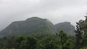 Sudhagad fort | |
 Sudhagad Fort | |
| Coordinates | 18°32′19.8″N 73°19′13.3″E / 18.538833°N 73.320361°E |
| Type | Hill fort |
| Height | 590 m(1935ft) |
| Site information | |
| Owner | Government of India |
| Controlled by | Ahmadnagar (1521–1594)
|
| Open to the public | Yes |
| Condition | Ruins |
| Site history | |
| In use | Capital fort |
| Materials | Stone |

Sudhagad / Bhorapgad is a hill fort situated in Maharashtra, India. It lies about 53 kilometres (33 mi) west of Pune, 26 kilometres (16 mi) south of Lonavla and 11 kilometres (6.8 mi) east of Pali in Raigad District. The summit is 620 metres (2,030 ft) above sea level.[1] Tthe entire area around the fort is declared a Sudhagad wildlife sanctuary.
History[]
The origin of this fort is said to date back to the 2nd century B.C [2][unreliable source?] the same age as the Thanale Caves and Khadsamble caves nearby. It was then called Bhrorapgad [3](after its presiding deity, Bhoraidevi). In 1436, it was captured by the Bahamani Sultan. In 1657, the Marathas took over and renamed it "Sudhagad"(the sweet one). It was a large fort and Sudhagad was considered by Chhatrapati Shivaji Maharaj as the capital of his kingdom. He surveyed it, but instead chose Raigad because of its central location.[citation needed]
In the regime of the Peshwas, the ‘Pantsachivas’ of Bhor[4] became the custodians of this fort. After the annexation of princely states in 1950 the fort became patron less. As a result, the fort is in a state of ruins, even though it escaped the wrath of the British.
Major Features[]
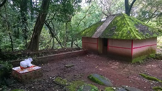
The first fort has several ruins of two temples dedicated to Lord Shiva. However, the temple of Bhoraidevi (its patron goddess) is well maintained temple.[4] On the large plateau at the summit,[5] there are two lakes, a house, a big granary, some tombs, a shrine (Vrindavan) and numerous other ruins, scattered around the fort area. There are three main gates the largest of which is called the Maha Darwaja.[4] From the top, other forts like Sarasgad, Korigad, Ghangad, Taila-Baila are clearly visible.
Current use[]
Sudhagad is a popular trekking destination as it is one of the better preserved forts in Maharashtra. It takes about 1–2 hours to reach the top of the fort. The trekking route from village Thakurwadi is most popular and regularly used. There are no water cisterns on the way. The night halt at the fort in any season can be made at Pantsachiv wada and Bhorai mata Mandir. There are two water ponds on the fort.[1][4] On the slopes of the fort there are trees of [what language is this?] which are used to make a popular walking stick.[4]
Gallary[]

Entrance of Sudhagad
Shiva Temple on the fort
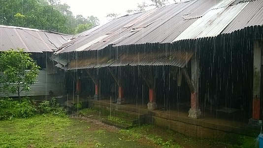
PantsachivWada in Rains

forest around the fort

Bhoraidevi temple

Entrance of Sudhagad as seen from the higher ramparts of the fort
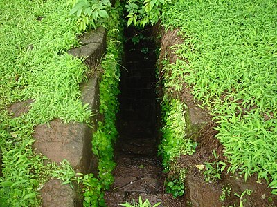
Secret escape route, Sudhagad fort

Sudhagad main entrance


References[]
- ^ Jump up to: a b Kapadia, Harish (2004). Trek the Sahyadris (Illustrated ed.). Indus Publishing. ISBN 81-7387-151-5. Retrieved 19 March 2009.
- ^ http://trekshitiz.com/trekshitiz/Ei/Sudhagad-Trek-Hill_forts-Category.html
- ^ http://raigad.nic.in/DG/1964/his_mediaeval_period.html
- ^ Jump up to: a b c d e Gunaji, Milind (2005). Offbeat Tracks in Maharashtra. Popular Prakashan. pp. 40–41. ISBN 81-7154-669-2. Retrieved 17 March 2009.
- ^ Kohli, M.S (2004). Mountains of India (Illustrated ed.). Indus Publishing. p. 254. ISBN 81-7387-135-3. Retrieved 19 March 2009.
- A rendezvous with Sahyadri by Harshal Mahajan
- 'Sudgagad Darshan', written by Mr. Suresh Potdar
Coordinates: 18°32′N 73°19′E / 18.54°N 73.32°E
See also[]
| Wikimedia Commons has media related to Sudhagad. |
- List of forts in Maharashtra
- List of forts in India
- Baji Prabhu Deshpande
- Marathi People
- Maratha Navy
- List of Maratha dynasties and states
- Maratha War of Independence
- Battles involving the Maratha Empire
- Maratha Army
- Maratha titles
- Military history of India
- List of people involved in the Maratha Empire
| hide | |
|---|---|
| Rulers |
|
| Peshwas |
|
| Amatya & Pratinidhi |
|
| Women |
|
| Maratha Confederacy |
|
| Battles |
|
| Wars |
|
| Adversaries |
|
| Forts |
|
| Coins | |
- Konkan
- Lonavala-Khandala
- Talukas in Maharashtra
- Forts in Raigad district
- Buildings and structures in Lonavala-Khandala
- Buildings and structures of the Maratha Empire
- 16th-century forts in India
- Tourist attractions in Pune district
- Hiking trails in India