Bieżanów-Prokocim
Bieżanów-Prokocim | |
|---|---|
 | |
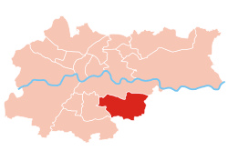 Location of Bieżanów-Prokocim within Kraków | |
| Coordinates: 50°0′58.78″N 20°1′52.18″E / 50.0163278°N 20.0311611°ECoordinates: 50°0′58.78″N 20°1′52.18″E / 50.0163278°N 20.0311611°E | |
| Country | |
| Voivodeship | Lesser Poland |
| County/City | Kraków |
| Government | |
| • President | |
| Area | |
| • Total | 18.47 km2 (7.13 sq mi) |
| Population (2014) | |
| • Total | 63,026 |
| • Density | 3,400/km2 (8,800/sq mi) |
| Time zone | UTC+1 (CET) |
| • Summer (DST) | UTC+2 (CEST) |
| Area code(s) | +48 12 |
| Website | http://www.dzielnica12.krakow.pl |

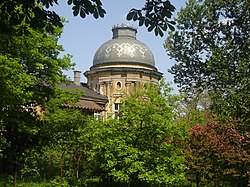
Bieżanów-Prokocim is one of 18 districts of Kraków, located in the southeast part of the city. The name Bieżanów-Prokocim comes from two villages that are now parts of the district.
According to the Central Statistical Office data, the district's area is 18.47 square kilometres (7.13 square miles) and 63 026 people inhabit Bieżanów-Prokocim.[1]
Subdivisions of Bieżanów-Prokocim[]
Bieżanów-Prokocim is divided into smaller subdivisions (osiedles). Here's a list of them.
- Bieżanów
- Bieżanów Kolonia
- Kaim
- Łazy
- Osiedle Kolejowe
- Osiedle Medyków
- Osiedle Na Kozłówce
- Osiedle Nad Potokiem
- Osiedle Nowy Bieżanów
- Osiedle Nowy Prokocim
- Osiedle Parkowe
- Osiedle Złocień
- Prokocim
- Rżąka
Population[]

References[]
- ^ "Information about Bieżanów-Prokocim district". Biuletyn Informacji Publicznej. Retrieved 30 August 2017.
External links[]
| Wikimedia Commons has media related to District XII Bieżanów-Prokocim (Kraków). |
This Poland location article is a stub. You can help Wikipedia by . |
Categories:
- Districts of Kraków
- Poland geography stubs