Mistrzejowice
Mistrzejowice | |
|---|---|
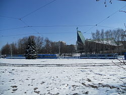 View of Church of St. Maksymilian Kolbe | |
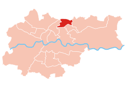 Location of Mistrzejowice within Kraków | |
| Coordinates: 50°5′58.47″N 20°0′19.72″E / 50.0995750°N 20.0054778°ECoordinates: 50°5′58.47″N 20°0′19.72″E / 50.0995750°N 20.0054778°E | |
| Country | |
| Voivodeship | Lesser Poland |
| County/City | Kraków |
| Government | |
| • President | Grażyna Janawa |
| Area | |
| • Total | 5.59 km2 (2.16 sq mi) |
| Population (2014) | |
| • Total | 53,015 |
| • Density | 9,500/km2 (25,000/sq mi) |
| Time zone | UTC+1 (CET) |
| • Summer (DST) | UTC+2 (CEST) |
| Area code(s) | +48 12 |
| Website | http://www.dzielnica15.krakow.pl |

Mistrzejowice is one of the 18 districts of Kraków; known as Dzielnica XV (District 15), located in the northern part of the city. The name Mistrzejowice comes from a village of same name (first mentioned in 1270) that is now a part of the district.[1]
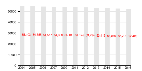
According to the Central Statistical Office data, the district's area is 5.59 square kilometres (2.16 square miles) and 53 015 people inhabit Mistrzejowice.[2]
Subdivisions of Mistrzejowice[]
Mistrzejowice is divided into smaller subdivisions (osiedles). Here's a list of them.[1]
- Batowice
- Dziekanowice
- Mistrzejowice
- Osiedle Bohaterów Września
- Osiedle Kombatantów
- Osiedle Mistrzejowice Nowe
- Osiedle Oświecenia
- Osiedle Piastów
- Osiedle Srebrnych Orłów
- Osiedle Tysiąclecia
- Osiedle Złotego Wieku
Population[]
References[]
- ^ a b Małgorzata Niechaj (2017), History of Mistrzejowice. Official website, Rada i Zarząd Dzielnicy XV Mistrzejowice (in Polish).
- ^ "Information about Mistrzejowice district". Biuletyn Informacji Publicznej. Retrieved 30 August 2017.
External links[]
![]() Media related to District XV Mistrzejowice (Kraków) at Wikimedia Commons
Media related to District XV Mistrzejowice (Kraków) at Wikimedia Commons
Categories:
- Districts of Kraków