Big Pool, Maryland
Big Pool, Maryland | |
|---|---|
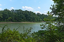 Big Pool, the body of water formed when the Chesapeake and Ohio Canal was made, which gave the name to the area | |
 Big Pool, Maryland | |
| Coordinates: 39°37′25″N 78°00′57″W / 39.62361°N 78.01583°WCoordinates: 39°37′25″N 78°00′57″W / 39.62361°N 78.01583°W | |
| Country | United States |
| State | Maryland |
| County | Washington |
| Area | |
| • Total | 0.107 sq mi (0.28 km2) |
| • Land | 0.107 sq mi (0.28 km2) |
| • Water | 0 sq mi (0 km2) |
| Elevation | 430 ft (130 m) |
| Population | |
| • Total | 82 |
| • Density | 770/sq mi (300/km2) |
| Time zone | UTC−5 (Eastern (EST)) |
| • Summer (DST) | UTC−4 (EDT) |
| Area codes | 301, 240 |
| GNIS feature ID | 589753[2] |


Big Pool is an unincorporated community in western Washington County, Maryland, United States. Its population was 82 as of the 2010 census.[1] It is between Clear Spring, Maryland and Hancock, Maryland along Interstate 70 and is officially a part of the Hagerstown Metropolitan Area.
To the south of Big Pool lies Fort Frederick State Park, a restored fort used during the French and Indian War. Also nearby is the Chesapeake and Ohio Canal National Historical Park, which lies near Ft. Frederick alongside the Potomac River.

Big Pool is also the name of a large body of water which is part of the Chesapeake and Ohio Canal. This pool occurs roughly at the 113 mile mark, and it is on what the canallers called the 14 mile level. A very famous musical artist also has a small getaway cabin home that he uses as a place to write music in private TPWK
References[]
- ^ a b c "2010 Census Gazetteer Files - Places: Maryland". U.S. Census Bureau. Retrieved February 11, 2017.
- ^ "Big Pool". Geographic Names Information System. United States Geological Survey.
External links[]
| Wikimedia Commons has media related to Big Pool, Maryland. |

- Unincorporated communities in Washington County, Maryland
- Unincorporated communities in Maryland
- Census-designated places in Washington County, Maryland
- Census-designated places in Maryland
- Washington County, Maryland geography stubs