Big Sur Coast Highway
 | |
|---|---|
| Cabrillo-San Simeon Highway; Roosevelt Highway | |
| Route information | |
| Defined by Streets and Highways Code § 301 | |
| Maintained by Caltrans | |
| Length | 71.2 mi[1][2] (114.6 km) |
| Tourist routes | |
| Restrictions | No trucks exceeding 30 feet kingpin to rearmost axle distance (Rio Rd to San Simeon)[3] |
| Major junctions | |
| South end | |
| North end | |
| Highway system | |

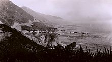
Big Sur Coast Highway is a section of California State Route 1 through the Big Sur region of California that is widely considered to be one of the most scenic driving routes in the United States, if not the world. It is both a National Scenic Highway and a California Scenic Highway, and was described by Australian painter Francis McComas as the "greatest meeting of land and water in the world".[4] Condé Nast Traveler named State Route 1 through Big Sur one of the top ten world-famous streets, comparable to Broadway in New York City and the Champs-Élysées in Paris. The road itself is a destination for visitors.
The Big Sur portion of Highway 1 is generally considered to include the 71-mile (114 km) segment adjoining the unincorporated region of Big Sur between Malpaso Creek near Carmel Highlands[1] in the north and San Carpóforo Creek near San Simeon in the south.[2]
Prior to its completion, the California coast south of Carmel and north of San Simeon was one of the most remote regions in the state, rivaling at the time nearly any other region in the United States for its difficult access. In 1920, the 26 mi (42 km) trip from Carmel to the Pfeiffer Ranch in the Big Sur valley in a light spring wagon pulled by two horses could be completed in about 11 hours, while a lumber wagon pulled by four horses could make the same trip in 13 hours.[5] The rough road ended in present-day Big Sur Village and could be impassible in winter. No road existed beyond Pfeiffer Ranch, only a horseback trail connecting the homesteads to the south.
The highway was first proposed by Dr. John L. D. Roberts, a physician who was summoned on April 21, 1894 to treat survivors of the wreck of the 493 tons (447 t) S.S. Los Angeles (originally USRC Wayanda), which had run aground near the Point Sur Light Station about 25 miles (40 km) south of Carmel-by-the-Sea. It took him 3+1⁄2 hours on his two-wheeled, horse-drawn cart, a very fast trip for the day.[6][7] The initial survey for the highway was completed in 1918, and its construction began in 1921.[8] The project ceased for two years in 1926 when funding ran out, and after 18 years of construction, the Carmel–San Simeon Highway was completed in 1937.[9] The route was incorporated into the state highway system and re-designated as Highway 1 in 1939.[6]
Along with the ocean views, this winding, narrow road, often cut into the face of towering seaside cliffs, dominates the visitor's experience of Big Sur. The stunning views, redwood forests, hiking, beaches, and other recreational opportunities have made Big Sur a popular destination for about 7 million people who live within a day's drive and visitors from across the world. The highway has been closed more than 55 times by landslides, and in May 2017, a 5,000,000-cubic-foot (140,000 m3) slide blocked the highway at Mud Creek, north of Salmon Creek near the San Luis Obispo County line, to just south of Gorda. The road was reopened on July 18, 2018, but is subject to closure during heavy storms. From January 28th 2021 to noon on April 23rd 2021, the roadway was closed at Rat Creek, a point 15 miles (24 km) south of Big Sur Village, where the entire road surface and the land under it washed into the ocean due to heavy storms. After 30 days of debris removal and only 56 days of construction, the highway was reopened on April 23rd 2021 in a ceremony attended by California Governor Gavin Newsom.[10]
History[]

Rancho San Jose y Sur Chiquito, including the land from Carmel to near Palo Colorado Canyon, was granted to José Castro in about 1848. Castro built the first trail from Monterey to Palo Colorado Canyon as early as 1853, when he filed a map of his purchase.[11][12]
After California gained statehood, a rough trail from Carmel to Mill Creek (present-day Bixby Canyon) was in use by about 1855 when it was declared a public road by the county.[12]: 4–2, 3 But the California coast south of Carmel and north of San Simeon remained one of the most remote regions in the state, rivaling at the time nearly any other region in the United States for its difficult access.[12] It remained largely an untouched wilderness until early in the twentieth century.[13] When the region was first settled by European immigrants in 1853, it was the United States' "last frontier".[14]
Yankee businessman Charles Henry Bixby bought several hundred acres south of Mill Creek and harvested lumber, tanbark, and lime. Without a road, he resorted to using a landing chute and hoist to transfer the goods to steamers anchored offshore.[15]
Bixby tried to persuade the county to build a road to Bixby Creek, but they refused, replying that "no one would want to live there".[16][17] In 1870, Bixby and his father hired men to improve the track and constructed the first wagon road including 23 bridges from the Carmel Mission to Bixby Creek.[18]
Further south, the Rancho El Sur grant extended from the mouth of Little Sur River inland about 2.5 miles (4.0 km) over the coastal mountains and south along the coast past the mouth of the Big Sur River to Cooper's Point. It was largely a cattle operation. There was a brief industrial boom in the late 19th century, but the early decades of the twentieth century passed with few changes, and Big Sur remained a nearly inaccessible wilderness.

In 1886, Bixby partnered with W. B. Post and they improved and realigned what became known as the Old Coast Road south to Post's ranch near Sycamore Canyon. At Bixby Creek Canyon, the road was necessarily built 11 miles (18 km) inland to circumvent the deep canyon. The road from Bixby Canyon climbed steep Cerro Hill and crossed the Little Sur River where its two forks diverted. The road entered the Cooper Ranch (formerly Rancho El Sur) and continued south about 7 miles (11 km) south to the Pfeiffer Ranch.[12]: 4–2, 3 In 1920, the 26 mi (42 km) trip from Carmel in a light spring wagon pulled by two horses could be completed in about 11 hours. A lumber wagon pulled by four horses could make the trip in 13 hours.[5] Bixby obtained a patent on April 10, 1889 for 160 acres (65 ha) south of Mill Creek.[19]
In 1891, visitor C. A. Canfield wrote about how a trip on the mail wagon to Posts took most of a day, where he remained the night. The next day he rode horseback over the South Coast Road with Thomas B. Slate. They reached Slates Hot Springs at about 5pm.[20] The single-lane road was closed in winter when it became impassable. Due to the steep and narrow road, even during the summer Coast residents would receive supplies via boat from Monterey or San Francisco.[12]: 4–4 Due to the limited access, settlement was primarily concentrated near the Big Sur River and present-day Lucia, and individual settlements along a 25 miles (40 km) stretch of coast between the two. The northern and southern regions of the coast were isolated from one another.[12]
In 1900, the country improved the road south to the forks of the Little Sur River.[21] Charles Howland, who drove the mail stage between Monterey and Big Sur, built the Idlewild Hotel in about 1900 on the Old Coast Road where it crossed the Little Sur River. The Pfeiffer family's hospitality was enjoyed by friends and strangers alike for years. They finally began charging guests in 1910, naming it Pfeiffer's Ranch Resort. It and the Idlewild Hotel were the earliest places to stay.[22]
In 1909, an advertisement for the Idlewild Hotel on the Little Sur River stated that the camp would be accessible by auto as soon as the "Cerro Grade", the stretch of road from the coast to the Little Sur River near Cerro Hill, was completed. In 1910, the Monterey Daily Cypress reported that Mr. and Mrs. A.E. Cooper "motored down to Mrs. Martha M. Cooper ranch at Sur, leaving Monterey at 12 midnight and arriving there at 2 a.m."[23] But the road was still very rough, and most goods including cheese produced on the Cooper Ranch was still shipped by boat to Monterey.[24] The Idlewild competed with the Pfeiffer Resort for guests through about 1920, when the Idlewild was forced out of business by Martha Cooper, who acquired the land. In 1904, residents extended the unpaved road from the Pfeiffer Resort to the Post Ranch, and then it was extended another 2.5 miles (4.0 km) south to Castro Canyon, near the present-day location of Deetjen's Big Sur Inn.
As late as the 1920s, only two homes in the entire region had electricity, locally generated by water wheels and windmills.[25]: 328 [26][27]: 64 Most of the population lived without power until connections to the California electric grid were established in the early 1950s. The region has always been relatively difficult to access and only the sturdiest and most self-sufficient settlers stayed.[12]
In July 1937, the California Highways and Public Works department described the journey, "There was a narrow, winding, steep road from Carmel south ... approximately 35 miles to the Big Sur River. From that point south to San Simeon, it could only be traveled by horseback or on foot."[28][29] The southern portion, which was for many years merely a foot and horse trail, became known as the "Coast Ridge Road".[25] It used to begin near the Old Post Ranch. It is currently only accessible on foot from near the Ventana Inn. It passes through private land and connects with the Nacimiento-Fergusson Road. It follows the crest of the coastal ridge south about 34 miles (55 km) to within a couple of miles of Cone Peak.[30][31]: 353 Both the Old Coast Road and the Coast Ridge Road are often unusable during and after winter storms.[12]
The southern region of Monterey County coast was isolated from the few settlements in the north by the steep terrain. The southern homesteaders were more closely tied to the people in the interior San Antonio Valley including the Jolon and Lockwood areas than to coastal communities to the north. A horse trail connected Jolon through present-day Fort Hunter Liggett to the Santa Lucia divide, from which several trails split to the coast or to the several mining camps.[32] Those who lived in the vicinity of the Big Sur River were connected with Monterey to the north.[12]
Road proposed[]
On April 21, 1894, Dr. John L. D. Roberts, a physician and land speculator who had founded Seaside, California and resided on the Monterey Peninsula, was summoned to assist treating survivors of the wreck of the 493 tons (447 t) S.S. Los Angeles (originally USRC Wayanda),[6] which had run aground near the Point Sur Light Station about 25 miles (40 km) south of Carmel-by-the-Sea. The ride on his two-wheeled, horse-drawn cart took him 3+1⁄2 hours, a very fast trip for the day.[6][7]
In 1897, he walked the entire stretch of rocky coast from Monterey to San Luis Obispo in five days and mapped out a course of the future road. He photographed the land and became the first surveyor of the route. He became convinced of the need for a road along the coast to San Simeon, which he believed could be built for $50,000 (equivalent to $928,512 in 2019).[6] In 1915, he presented the results of his survey and photographic work to a joint session of the California legislature. Roberts initially promoted the coastal highway to allow access to a region of spectacular beauty, but failed to obtain funding.[33][7]
Funding[]

California was booming during the 1920s, driven by rapidly expanding aviation, oil, and agricultural business. The number of state residents doubled between 1910 and 1930. This stimulated the rapid expansion of the state's road network.[34] State Senator Elmer S. Rigdon from Cambria, at the southern end of the Big Sur region, embraced the necessity of building the road. He was a member of the California Senate Committee on Roads and Highways and promoted the military necessity of defending California's coast which persuaded the legislature to approve the project. In 1919, the legislature approved building Route 56, or the Carmel – San Simeon Highway, to connect Big Sur to the rest of California. A $1.5 million bond issue was approved by voters, but construction was delayed by World War I. Federal funds were appropriated and in 1921 voters approved additional state funds.[6][16] Additional funds were made available from the National Industrial Recovery Act in June, 1933. California received $15 million for state highway work.[35]
Construction[]
The California state legislature passed a law in 1915 that allowed the state to use convict labor under the control of the State Board of Prison Directors and prison guards. In 1918, state highway engineer Lester Gibson led a mule pack train along the Big Sur coast to complete an initial survey to locate the future Coast Highway.[8] When the convict labor law was revised in 1921, it gave control of the convicts and camps to the Division of Highways, although control and discipline remained with the State Board of Prison Directors and guards.[8] The law helped the contractors who had a difficult time attracting labor to work in remote regions of the state.[36]
1921-1924[]
The first contract was awarded in 1921. The contractor Blake and Heaney built a prison labor camp for 120 prisoners and 20 paid laborers at Piedras Blancas Light Station. They began work on 12 miles (19 km) of road between Piedras Blancas Light Station near San Simeon and Salmon Creek. Most of the road lay within San Luis Obisbo County.[8] As they progressed, the work camp was moved 9 miles (14 km) north to Willow Creek and then another 10 miles (16 km) north to Kirk Creek.[6] When the section to Salmon Creek was completed, the crew began work on the road north toward Big Creek.
Contractor George Pollock Company of Sacramento started construction next on one of the most remote segments, a 13 miles (21 km) stretch between Anderson Canyon and Big Sur in September, 1922. The region was so remote and access so poor that the company brought most of its supplies and equipment in by barge at a sheltered cove near the middle of the project. Machines were hoisted to the road level using steam-powered donkey engines.
Construction required extensive excavation utilizing steam shovels and explosives on the extremely steep slopes. The work was dangerous, and accidents and earth slides were common. One or more accidents were reported nearly every week. Equipment was frequently damaged and lost. In one incident, a steam shovel fell more than 500 feet (150 m) into the ocean and was destroyed.[6][37]
Overcoming all the difficulties, the crews completed two portions of the highway in October, 1924, the southern section from San Simeon to Salmon Creek and a second segment from the Big Sur Village south to Anderson Creek.[8] When these sections were completed, the contractor had used up all of the available funds and work was halted.
California Governor Friend William Richardson felt the state could not afford to complete the 30 miles (48 km) remaining, including the most difficult section remaining between Salmon Creek and Anderson Canyon.[6]
1928-1937[]
In March 1928, work was renewed. Convicts were paid $2.10 per day but the cost of clothing, food, medical attention, toilet articles, transportation to the camp, construction tools, and even their guards was deducted from their pay. Actual wages were just under $0.34 per day. If a convict escaped, the law provided for a reward of $200 for their capture and return. The reward was automatically deducted from the all other convict's pay.[6]
San Quentin State Prison set up three temporary prison camps to provide unskilled convict labor to help with road construction. The first was built in March, 1928 near Salmon Creek for 120 prisoners and 20 free men. They worked north toward Big Creek, about 46 miles (74 km) south of Carmel.

In July 1928, a second camp was built near the mouth of the Little Sur River on the El Sur Ranch about 18 miles (29 km) south of Carmel. They worked on an 8 miles (13 km) section of the highway from 9 miles (14 km) to the south, to Rocky Creek, about 4 miles (6.4 km) to the north. When they completed this portion in 1932, the contractor moved the work camp south to Anderson Creek. From this camp, they built the road south 7 miles (11 km) south to Big Creek. When this task was finished, the workers almost completely reconstructed and realigned he portion of the road from Anderson Creek to Big Sur that had been completed in 1924.[6] Two and three shifts of convicts and free men worked every day, using four large steam shovels.[6] Locals, including writer John Steinbeck, also worked on the road.[33]
Construction methods[]
Walt Trotter, a long-time resident of the coast who had many years of experience in construction, observed in 1978 that the road could have been better built. "Had this been a modern constructed way", he said, "it would have been all infilled, tailgated, the brush would have been cleared off all the cuts, they would have taken the dozers and gone down and compacted all the fill." Still, looking at a picture of the construction, he said, "Then they would have started up here at the top of the hill and made nice slopes all the way down and benched it down and you wouldn't have had all this..."[35]
Bridges required[]


Road construction necessitated construction of 29 bridges, the most difficult of which was the bridge over Bixby Creek, about 13 miles (21 km) south of Carmel. Upon completion, the Bixby Creek Bridge was 714 feet (218 m) long, 24 feet (7.3 m) wide, 260 feet (79 m) above the creek bed below, and had a main span of 360 feet (110 m).[38] The bridge was designed to support more than six times its intended load.[39] When it was completed on October 15, 1932, Bixby Creek Bridge was the largest arched highway structure in the Western states. Five more reinforced concrete bridges were built at Rocky, Granite, Garapata, Malpaso, and Wildcat Creeks.[28] But the entire highway was not completed for another five years.[6] All of the concrete arch bridges were listed in the National Register of Historic Places in 1986. They were also included in the California Register of Historic Resources in 1992.[40][41][6]
The contractor built a large bridge of Redwood with a span of 514 feet (157 m) at Dolan Creek because of the considerable distance required to haul concrete. They also built wood bridges at Lime Creek, Prewitt Creek, Wild Cattle Creek and Torre Canyon. Steel bridges were built at Burns Creek, San Simeon Creek, Pico Creek, Castro Canyon, Mill Creek and Little Pico Creek. The timber and steel bridges, with the exception of Castro Canyon and Mill Creek, were all replaced with concrete bridges later on.[41]
Water fountains[]
To provide water to thirsty travelers, the Civilian Conservation Corps built between 1933 and 1937 six hand-crafted stone drinking fountains, indicated by their distance from the Monterey/San Luis Obispo County line:[42]
- Soda Springs 3.8 miles (6.1 km) 35°47′39″N 121°20′30″W / 35.794272°N 121.341771°W
- Big Redwood 5.21 miles (8.38 km) 35°50′11″N 121°23′21″W / 35.836476°N 121.389265°W
- Willow Creek/Seven Stairs 12 miles (19 km) 35°53′38″N 121°27′38″W / 35.893760°N 121.460486°W
- Lucia 20.4 miles (32.8 km) 36°00′21″N 121°30′33″W / 36.005744°N 121.509089°W
- Rigdon 27 miles (43 km) 36°03′22″N 121°35′22″W / 36.055973°N 121.589506°W

The crews built masonry stone walls around local springs at each location. One of the fountains is believed to have been lost due to one of the many landslides. Some of them are still operational.[43]
Completion[]
After 18 years of construction, aided by New Deal funds during the Great Depression, the paved two-lane road was completed and opened on June 17, 1937.[9] About 70,000 pounds (32,000 kg) of dynamite was used to help blast more than 10,000,000 cubic yards (7,600,000 m3) of granite, marble and sandstone. Bixby Bridge alone required 300,000 board feet of Douglas fir, 6,600 cubic yards (5,000 m3) of concrete, and 600,000 pounds (270,000 kg) of reinforcing steel.[44]
On June 27, 1937, Governor Frank Merriam led a caravan from the Cambria Pines Lodge to San Simeon, where dedication ceremonies began. The wife of the late Senator Elmer Rigdon, who had promoted the bridge and obtained funding, dedicated a silver fir to her husband's memory. A water fountain in a turnout between Vicente Creek Bridge and Big Creek Bridge, four miles north of Lucia, was dedicated as the Elmer Rigdon Memorial Drinking Fountain.[40] The Native Sons of the Golden West dedicated two redwood trees. The caravan then drove north to Pfeiffer Redwoods State Park, where a larger dedication ceremony was held.[6] The initial $1.5 million bond measure was not enough. The final cost when the road was completed 18 years later was $19 million (equivalent to $378.05 million in 2020).[44][7]
The road was initially called the Carmel-San Simeon Highway, but was better known as the Roosevelt Highway, honoring then-current President Franklin D. Roosevelt. The road was frequently closed for extended periods during the winter, making it a seasonal route.[36] The new route was incorporated into the state highway system and re-designated as Highway 1 in 1939. In 1940, the state contracted for "the largest installation of guard rail ever placed on a California state highway", calling for 12 miles (19 km) of steel guard rail and 3,649 guide posts along 46.6 miles (75.0 km) of the road.[36] In 1941, 160 inches (410 cm) of rain fell on Big Sur, and the state considered abandoning the route. Slides were so common that gates were used to close the road to visitors at the northern and southern ends during the winter.[45] During World War II, nighttime blackouts along the coast were ordered as a precaution against Japanese attack.[36]
Impact on residents[]

The opening of Highway 1 in 1937 dramatically altered the local economy. Before the highway was completed, a developer who wanted to build a subdivision offered to buy the Pfeiffer Ranch from John and Florence Pfeiffer for $210,000 ($3.25 million in 2020). John was the son of Big Sur pioneers Michael Pfeiffer and Barbara Laquet. Pfeiffer wanted the land preserved and he sold 680 acres (2.8 km2) to the state of California in 1933.[46] This became the foundation of Pfeiffer Big Sur State Park.[47] The Civilian Conservation Corps built campgrounds, build ings, fences, a footbridge, and trails in Pfeiffer Big Sur State Park. They used redwood lumber and river rocks as building materials to create a wood and stone "park rustic" style. They also fought fires and removed poison oak. A relative of the Pfeiffer family built the Big Sur River Inn in 1934.[46]
Land values rose. Some residents regretted the access provided by the highway. Jaime de Angulo, who first arrived in Big Sur in 1915, wrote:[48]
But my coast is gone, you see. It will be an altogether different affair. I don't know what to think of it, on the whole. My first reaction of course was one of intense sorrow and horror. My Coast had been defiled and raped. The spirits would depart. And as I travelled with Mr. Farmer (the stage man) past Castro's place, past Grimes' cañon, and contemplated the fearful gashes cut into the mountain, and the dirt sliding down, right down into the water in avalanches, my heart bled.
Many original settlers were extremely upset by the destruction caused resulting from the construction. Machinery blasted through the great cliffs, scarring granite promontories, defiling canyons and waterfalls with debris.[49] The construction employed primitive construction methods. The laborers used tons of dynamite and blasted large amounts of earth and rock debris over the edge of the road and often into the ocean. Many members of the original families were upset by the damage to the environment caused by the construction. When the workers cut into hillsides, they left naked scars void of brush, and pushed "millions and millions and billions of yards of earth" down the slopes and into the oceans.[50]
Deetjen's Big Sur Inn was opened in 1936. The region's economy and population growth was strongly influenced by the construction of permanent and summer homes. Many visitor facilities were constructed. The agricultural and minor industrial economy was quickly supplanted by a tourism-oriented economy.[51][52]
Recent history[]
The remaining segment of the unpaved Old Coast Road intersects with the Coast Highway at Bixby Creek Bridge and climbs steeply inland up Cerro Hill, traversing the El Sur Ranch. It crosses the Little Sur River near the junction of the North and South forks, formerly the location of the Idlewild Hotel from about 1900 to 1921. The road then descends and rejoins Highway 1 across from the main entrance of Andrea Molera State Park. It can be impassable in wet weather and is suitable for high-clearance vehicles. The Coast Ridge Road south of Posts is closed to vehicles. From Posts, it climbs to the coastal summit, and follows the westernmost ridge of the Santa Lucia Range from Big Sur to Cone Peak. From Cone Peak the road extended south, crossing Nacimiento Summit and continuing south past Chalk Peak to where the road is now named Plaskett Ridge Road. From there it began a westerly descent to a point along the South Coast near Sand Dollar Beach and Plaskett. Segments of the Old Coast Ridge Road have been given new names, and some sections of the road are closed. Portions of it are now a Forest Service trail.[53]
Highway 1 has been at capacity for many years. The state legislature permanently limited the road along the Big Sur coast to two lanes, halting any proposals to upgrade the route to a freeway.[54]: 157 In 1977, the U.S. Forest Service noted in its environmental impact statement, "Highway 1 has reached its design capacity during peak-use periods."[30] It is currently at or near capacity much of the year. The primary transportation objective of the Big Sur Coastal Land Use plan is to maintain Highway 1 as a scenic two-lane road and to reserve most remaining capacity for the priority uses of the act.[50]
Repeated closings[]
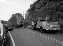
The steep topography, active faults, diverse geology, and seasonal storms combine to make the rugged Big Sur area one of the most landslide-prone stretches of the California coast.[55] As a result, the California Department of Transportation has had to make many repairs to the road. Highway 1 has been closed on more than 55 occasions due to damage from landslides, mudslides, erosion, and fire.[56]: 2–2 Aside from Highway 1, the only access to Big Sur is via the winding, narrow, 24.5 miles (39.4 km) long Nacimiento-Fergusson Road, which from Highway 1 south of Lucia passes east through Fort Hunter Liggett to Mission Road in Jolon. It's about a 50 miles (80 km) and hour-and-a-half drive to U.S. Route 101 (US 101).[57]
On January 15, 1952, the highway was closed 7 miles (11 km) north of San Simeon to Big Sur due to "numerous heavy slides".[58] December 1955 was the fifth wettest since 1872. At the Big Sur Maintenance Station, 8.45 inches of rain was recorded in one 24-hour period on December 23. Torrential rains caused flood conditions throughout Monterey County and Highway 1 in Big Sur was closed in numerous locations due to slides.[59]
A series of storms in the winter of 1983 caused four major road-closing slides between January and April, including a large 963 feet (294 m) high landslide slide near Julia Pfeiffer Burns State Park and McWay Falls that buried Highway 1 with 4,000,000 cubic yards (3,100,000 m3) of rocks and dirt. Twenty-six bulldozers worked for 22 weeks to clear the highway.[60] The repair crews pushed the slide into the ocean which ended up creating a beach inside McWay Cove that did not exist before.[61] It was up to that date the largest earth-moving project ever undertaken by CalTrans.[54]: 157 CalTrans routinely pushed slide debris into the ocean shore until the Monterey Bay National Marine Sanctuary was created in 1992, which made dumping material into the ocean illegal. Highway 1 was closed for 14 months.[56]: 2–10
In 1998, about 40 different locations on the road were damaged by El Niño storms, including a major slide 2 miles (3.2 km) south of Gorda that closed the road for almost three months.[37] The Associated Press described the damage as "the most extensive destruction in the 60-year history of the world famous scenic route".[58]
In March 2011, a 40 feet (12 m) section of Highway 1 just south of the Rocky Creek Bridge collapsed, closing the road for several months until a single lane bypass could be built.[62] The state replaced that section of road with a viaduct that wraps around the unstable hillside.[57] On January 16, 2016, the road was closed for portions of a day due to a mudslide near Julia Pfeiffer Burns State Park.[63]
In January 2014, CalTrans completed construction of a new bridge and rock shelter at Pitkins Curve in Big Sur, one of the ongoing trouble spots on Highway 1 near Limekiln State Park.[64]

One individual was killed while repairing the road. In 1983, Skinner Pierce died while clearing the slide near Julia Pfeiffer Burns State Park when the bulldozer he was operating fell down the slide into the ocean. His body was never recovered.[54]: 157
2017 closures[]
During the summer of 2016, the road was closed on several occasions due to the Soberanes Fire. During the following winter, Pfeiffer Big Sur State Park received more than 60 inches (150 cm) of rain, while other locations received up to 83 inches (210 cm), the most rain recorded since 1915.[65][66] In early February 2017, several mudslides blocked the road in more than half a dozen locations. The failure of the Pfeiffer Canyon Bridge and two major slides closed the highway for more than 14 months. The closure of Highway 1 in two locations isolated the 60 families and 350 residents between the two locations for weeks, forced Esalen Institute to evacuate guests by helicopter, and residents to ferry supplies in the same way.[67]
- Pfeiffer Canyon Bridge failure

Just south of Pfeiffer Big Sur State Park, shifting earth damaged a pier supporting a bridge over the 320 feet (98 m) deep Pfeiffer Canyon. CalTrans immediately closed the highway on February 12, 2017 and announced the next day that the Pfeiffer Canyon Bridge was damaged beyond repair and would have to be replaced.[68] Highway 1 remained closed.[69][70][71]
CalTrans immediately began planning to replace the bridge and contracted with XKT Engineering on Mare Island to construct a replacement single-span steel girder bridge. The new roadway was designed without support piers. The rebuilt bridge opened on October 13, 2017 at a cost of $24 million after 8 months of road closure.[72][73]
- Paul's Slide
To the south, a slide totalling about 2,000,000 cubic yards (1,500,000 m3) million closed Highway 1 in February at a perennial problem point known as Paul's Slide, north of the Nacimiento-Ferguson Road. Businesses and residents were isolated between the Pfeiffer Canyon Bridge and Paul's Slide. For about two weeks supplies and residents were ferried in and out by helicopter.[74][65] CalTrans contractors finally opened the road for residents and delivery trucks to limited one-way controlled traffic.
- Mud Creek slide

On May 20, the largest slide in the highway's history at Mud Creek blocked the road 1 mile (1.6 km) southeast of Gorda or about 60 miles (97 km) south of Monterey. The slide began 1,100 feet (340 m) up the side of the mountain and dumped an estimated 5,000,000 cubic yards (3,800,000 m3),[71] or about 1.5 million tons of dirt, on to the road and more than 550 feet (170 m) into the ocean. The slide was national and worldwide news.[71][75][76][77][78] Larger than the slide that blocked the highway in 1983 at Julia Pfeiffer Burns State park, it covered one-quarter-mile (.40 km) of the highway and buried it up to 160 feet (49 m) deep in some places.[71][79][80][81][82][83] On August 2, 2017, CalTrans decided to rebuild the highway over the slide instead of clearing it.[84] To stabilize the toe of the slide and prevent the surf from further eroding the slide, CalTrans contractors brought in about 200,000 short tons (180,000 t) of rock to build the revetment. Crews worked seven days a week, at least 12 hours per day, from January 2017 until mid-July 2018 to get the road repaired. It was reopened on July 18, 2018 at a cost of $54 million.[71][79][85]
CalTrans announced in December 2019 that they would preemptively close the highway in advance of forecasts of significant rain.[86]
2021 closure[]
Following several summers of intense drought and wildfire, which weakened soils, a rainy 2020-2021 winter season produced mudslides in the Big Sur region.[87] On Friday, 28 January, 2021, a large section of the road collapsed into the sea near Rat Creek, 15 miles (24 km) south of the community of Big Sur Village. The breach began the day before, with California Highway Patrol officer noting loss of the southbound (ocean side) lanes. Caltrans noted the debris flow the same day, and ordered an emergency repair. When repair crews arrived Friday, they reported that the both lanes of the road had been lost. Media drone footage showed a complete loss of the road at the breech, including land on the inland side of the road.[88]
Popularity[]
The drive along Highway 1 has been described as "one of the best drives on Earth", and is considered one of the top 10 motorcycle rides in the United States.[89] Highway 1 was named the most popular drive in California in 2014 by the American Automobile Association.[90] Condé Nast Traveler named State Route 1 through Big Sur one of the top 10 world-famous streets, comparable to Broadway in New York City and the Champs-Élysées in Paris.[91] Most of the nearly 7 million tourists who currently visit Big Sur each year never leave Highway 1, because the adjacent Santa Lucia Range is one of the largest roadless coastal areas in the entire United States; Highway 1 and the Nacimiento-Fergusson Road offer the only paved access into and out of the region.
The beauty of the scenery along the narrow, two-lane road attracts enormous crowds during summer vacation periods and holiday weekends, and traffic is frequently slow.[92] Visitors have reported to the California Highway Patrol hours-long stop-and-go traffic from Rocky Creek Bridge to Rio Road in Carmel during the Memorial Day weekend.[93] The highway winds along the western flank of the mountains mostly within sight of the Pacific Ocean, varying from near sea level up to a 1,000-foot (300 m) sheer drop to the water. Most of the highway is extremely narrow, with tight curves, steep shoulders and blind turns. The route offers few or no passing lanes and, along some stretches, very few pullouts. The sides are occasionally so steep that the shoulders are virtually non-existent.[94]
Traffic and parking problems[]

Since the introduction of smart phones and social media, the popularity of certain Big Sur attractions like Bixby Creek Bridge, Pfeiffer Beach, McWay Falls, and the Pine Ridge Trail have dramatically increased.[95] During holiday weekends and most summer vacation periods, traffic congestion and parking in these areas can be extremely difficult.[96] Some locations have limited parking, and visitors park on the shoulder of Highway 1, sometimes leaving inadequate space for passing vehicles. At Bixby Creek Bridge, visitors sometimes park on the nearby Old Coast Road, blocking the road and residents' access to their homes. Highway 1 is often congested with traffic backed up behind slow drivers. There are a large number of unpaved pull outs along the highway, but there are only three paved road-side vista points allowing motorists to stop and admire the landscape.[97][98] Due to the large number of visitors, congestion and slow traffic between Carmel and Posts is becoming the norm.[99] There have been reports of tourists leaving their vehicle in the middle of Highway 1 to stop and take pictures.[100][101]
In 2016, the average daily vehicle counts at the Big Sur River Bridge (milepost 46.595) were 6,500, a 13% increase from 5,700 in 2011. An average daily vehicle count of 6,500 translates to 2.3 million vehicles per year.[102] Counts up to 14,200 were obtained from measurements at the northern and southern boundaries of the region. The lowest number was found at the border of the Monterey and San Luis Obispo County lines.[103]
When the highway opened in 1937, average daily vehicle traffic was over 2,500, but dropped to 1,462 the next year. It rose somewhat until December 1, 1942, when mandatory gas rationing was instituted during World War II. The rationing program and a ban on pleasure driving extremely limited the number of visitors who made the trip to Big Sur. On August 15, 1945, World War II gas rationing was ended on the West Coast of the United States.[104][105] The number of vehicles rose dramatically in 1946 and increased steadily. Tourism and travel boomed along the coast. When Hearst Castle opened in 1958, a huge number of tourists also flowed through Big Sur.[51]
Visitors continued to increase during the 1960s, due in part to the opening of several major attractions in the area, especially the Esalen Institute. The filming of The Sandpiper in 1964 and its release in 1965 dramatically increased public awareness of the region. In 1970, the average daily vehicle count was 3,700, and as of 2008, reached about 4,500.[106]
Residents are especially concerned about traffic along single-lane Sycamore Canyon Road to Pfeiffer Beach. The beach has been owned by the U.S. Forest Service since 1906, and they own an easement along the road. About 80 homes are situated along Sycamore Canyon Road. About 600 vehicles a day use the road, but there are only 65 parking spaces at the beach itself, so some tourists park on the highway and walk the 2 miles (3.2 km) road to the beach, which is illegal because the road is so narrow. On Sunday of Memorial Day weekend in 2018, the parking lot was full all day. Parks Management Company, which manages the day-use parking lot at Pfeiffer Beach, turned away more than 1,000 cars from the entrance to Sycamore Canyon Road. Visitors were redirected to the parking lot the Big Sur Station, a nearby multi-agency facility, where for $15 they could park and take a newly introduced shuttle service to the beach.[107] The Coast Property Owners Association had been pressuring the Forest Service for a shuttle service for more than a year.[96][108]
Bixby Creek Bridge issues[]
Due to the large number of visitors, congestion and slow traffic between Carmel and the Bixby Creek Bridge is frequently the norm during popular holiday and vacation periods.[109] Residents complain that the bridge area is "like a Safeway parking lot". Traffic can come to a standstill as motorists wait for a parking spot. There is a pull out to the north and west side of Highway 1, but when it is full, visitors sometimes fail to completely pull off the highway, leaving inadequate space for passing vehicles.[110]
There are no toilets within several miles of the bridge, and visitors resort to defecating in nearby bushes. Residents complain about toilet paper, human waste, and trash littering the roadside.[100]
Scenic designations[]
The section of Highway 1 running through Big Sur is widely considered one of the most scenic driving routes in the United States, if not the world.[111][112][113] The views are one reason that Big Sur was ranked second among all United States destinations in TripAdvisor's 2008 Travelers' Choice Destination Awards.[114] The unblemished natural scenery owes much of its preservation to the highly restrictive development plans enforced in Big Sur; no billboards or advertisements are permitted along the highway and signage for businesses must be modestly scaled and of a rural nature conforming to the Big Sur region. The state of California designated the 72-mile (116 km) section of the highway from Cambria to Carmel Highlands as the first California Scenic Highway in 1965.[115][116] In 1966, First Lady Lady Bird Johnson led the official scenic road designation ceremony at Bixby Creek Bridge.[36] In 1996, the road became one of the first designated by the federal government as an "All-American Road" under the National Scenic Byways Program.[97][117][118][6] The designation defined the highway itself as the destination.[119] CNN Traveler named McWay Falls as the most beautiful place in California.<ref>"The Most Beautiful Place in Every U.S. State". Archived from the original on 2019-07-01. Retrieved 2020-01-06.
See also[]
 California Roads portal
References[]
- ^ Jump up to: a b Surfer Magazine (21 February 2006). Surfer Magazine's Guide to Northern and Central California Surf Spots. Chronicle Books. p. 97. ISBN 978-0-8118-4998-2. Archived from the original on 16 November 2017. Retrieved 13 January 2011.
- ^ Jump up to: a b Chatfield, Michael (5 May 2014). "Big Sur Magic – Carmel Magazine". Carmel Magazine. Archived from the original on 28 April 2017. Retrieved 14 December 2016.
- ^ "Truck Networks on California State Highways" (PDF). California Department of Transportation. Retrieved January 5, 2020.
- ^ Steakley, Douglas (2011). Photographing Big Sur: Where to Find Perfect Shots and How to Take Them. Woodstock, Vermont: The Countryman Press. p. 9. ISBN 9781581579413.
- ^ Jump up to: a b Wall, Rosalind Sharpe. A Wild Coast and Lonely: Big Sur Pioneers 1989, Wide World Publishing; San Carlos, California; pages 126–130
- ^ Jump up to: a b c d e f g h i j k l m n o p "The Building of Highway One". Historical Moments. Cambria Historical Society. Archived from the original on 23 January 2012. Retrieved 30 June 2013.
- ^ Jump up to: a b c d "Dr. John Roberts". cambriahistory.org. Archived from the original on 2017-12-29. Retrieved 2017-12-29.
- ^ Jump up to: a b c d e "Building of Highway One". cambriahistory.org. Archived from the original on 2012-03-09. Retrieved 2020-01-06.
- ^ Woods Novoa, Kate. "Highway One opens to ceremony". bigsurkate. Retrieved 24 April 2021.
- ^ "Diseño map of Rancho San Jose Y Sur Chiquito" (GLO No. 552 ed.). Monterey County, California. Archived from the original on October 12, 2016. Retrieved August 14, 2016.
- ^ Jump up to: a b c d e f g h i JRP Historical Consulting Services (November 2001). "Big Sur Highway Management Plan" (PDF). Corridor Intrinsic Qualities Inventory Historic Qualities Summary Report. CalTrans. p. 38. Archived (PDF) from the original on September 5, 2008. Retrieved November 14, 2009.
- ^ Marvinney, Craig A. (1984). "Land Use Policy Along the Big Sur Coast of California; What Role for the Federal Government?". UCLA Journal of Environmental Law & Policy. Regents of the University of California. Accessed 22 August 2016.
- ^ "The Big Sur – Last Frontier of United States" (11). Reading, Pennsylvania: Reading Eagle. February 7, 1960. p. 75. Retrieved 25 August 2016.
- ^ McGlynn, Betty Hoag (September 1, 1988). "Partington Landing: of Poets, Artists, and Ships in the Big Sur Country" (PDF). Noticias del Puerto de Monterey. The Monterey History and Art Association. 24 (3). Archived from the original (PDF) on 23 March 2019. Retrieved 23 March 2019.
- ^ Jump up to: a b Newland, Renee. "Bixby Creek Bridge". Monterey County Historical Society. Archived from the original on 16 July 2004. Retrieved 13 November 2011.
- ^ McCabe, Michael (May 18, 2001). "Big Sur Trust buys historic overlook / Notley's Landing was important in timber trade". San Francisco Chronicle. Archived from the original on 9 October 2016. Retrieved 6 October 2016.
- ^ Walton, John (2007). "The Land of Big Sur Conservation on the California Coast" (PDF). California History. 85 (1). Archived from the original (PDF) on August 22, 2015e. Retrieved 14 August 2016.
- ^ "Charles H Bixby, Patent #CACAAA-090682". The Land Patents. Archived from the original on 2 March 2019. Retrieved 20 August 2016.
- ^ Canfield, C.A.Old Coast Country Monterey Cypress December 5, 1891. page 5
- ^ Norman, Jeff (2004). Big Sur. Charleston, S.C.: Arcadia Publishing. p. 53. ISBN 9780738529134. Retrieved 2 January 2021.
- ^ "The History of Big Sur Lodge". www.bigsurlodge.com. Archived from the original on 10 February 2018. Retrieved 10 February 2018.
- ^ Enjoyed Motor Party to Cooper Ranch at Sur Monterey Daily Express. Monterey, California. November 29, 1910. page 1.
- ^ Cheese Made Down the Coast Monterey Daily Express. Monterey, California. June 7, 1911. page 1.
- ^ Jump up to: a b Henson, Paul; Donald J. Usner (1993). "The Natural History of Big Sur" (PDF). University Of California Press. Archived from the original (PDF) on June 17, 2010. Retrieved 12 August 2016.
- ^ Woolfenden, John (1981). Big Sur: A Battle for the Wilderness 1869–1981. Pacific Grove, California: The Boxwood Press. p. 72.
- ^ Thornton, Stuart. "A Dirty Journey to the Lost City of the Santa Lucias". Archived from the original on 2018-11-20. Retrieved 2020-01-06.
- ^ Jump up to: a b Gibson, Lester (July 1937). "A Dream Comes True, Illustrated". California Highways and Public Works. Sacramento, California: Division of Highways of the Department of Public: Works. 15 (7).
- ^ "California Highway 1 – Carmel Magazine". carmelmagazine.com. Archived from the original on 2017-07-12. Retrieved 2018-01-08.
- ^ Jump up to: a b Los Padres National Forest (N.F.), Big Sur Coastal Unit Plan: Environmental Impact Statement. United States. Forest Service. 1977.
- ^ Henson, Paul (1993). The natural history of Big Sur. Usner, Donald J. Berkeley: University of California Press. ISBN 9780520205109. OCLC 25316584.
- ^ "The Monterey County Historical Society News December 2000" (PDF). Archived (PDF) from the original on 2012-09-05. Retrieved 2020-01-06.
- ^ Jump up to: a b Longfellow, Rickie (April 7, 2011). "Back in Time". U.S. Department of Transportation, Federal Highway Administration. Archived from the original on 29 January 2012. Retrieved 16 December 2011.
- ^ Angela, Penrose (2017). No Ordinary Woman: The life of Edith Penrose. Oxford University Press. p. 7. ISBN 9780198753940. OCLC 988170570.
- ^ Jump up to: a b Walling, Paula (December 1978). "The Construction of Highway One" (PDF). Big Sur Gazette. p. 14. Archived (PDF) from the original on 25 May 2017. Retrieved 8 January 2020.
- ^ Jump up to: a b c d e Pavlik, Robert C. (November 1996). "Historic Resource Evaluation Report on the Rock Retaining Walls, Parapets, Culvert Headwalls and Drinking Fountains along the Carmel to San Simeon Highway" (PDF). California Department of Transportation. Archived (PDF) from the original on December 26, 2016. Retrieved August 23, 2016.
- ^ Jump up to: a b "Resource Issues: Landslide and Debris". National Oceanic and Atmospheric Administration. Archived from the original on 13 September 2016. Retrieved 6 October 2016.
- ^ Bixby Creek Bridge (1933) at Structurae
- ^ Vitousek, Sean. "Big Sur Bixby Bridge". Archived from the original on 2011-11-19. Retrieved November 13, 2011.
- ^ Jump up to: a b "My Coastal California". mycoastalcalifornia.blogspot.com. Archived from the original on 2017-12-22.
- ^ Jump up to: a b "Other Highway One Bridges". cambriahistory.org. Archived from the original on 2017-12-30. Retrieved 2017-12-29.
- ^ "Big Sur Interactive Highway Maps with Slide Names & Mile Markers". Retrieved 15 June 2020.
- ^ Handy, Lucas. "Strategies to enjoy semi-secret Big Sur". Monterey County Weekly. Retrieved 14 January 2018.
- ^ Jump up to: a b Longfellow, Rickie. "California's Pacific Coast Highway-Highway One". www.fhwa.dot.gov. Federal Highway Administration. Archived from the original on 2017-11-17. Retrieved 2017-12-29.
- ^ "Is Big Sur's Highway 1 worth saving?". Archived from the original on 2017-06-07.
- ^ Jump up to: a b "Pfeiffer Big Sur State Park" (PDF). CALIFORNIA STATE PARKS. Archived (PDF) from the original on 7 January 2018. Retrieved 10 February 2018.
- ^ Heid, Analise Elliot (2013). Hiking & Backpacking Big Sur: A Complete Guide to the Trails of Big Sur, Ventana Wilderness, and Silver Peak Wilderness (Second ed.). Wilderness Press. p. 84. ISBN 978-0899977270.
- ^ "Jaime De Angulo: "But My Coast Is Gone, You See ... The Spirits Would Depart"". www.redegggallery.com. April 7, 2011. Archived from the original on 10 February 2018. Retrieved 10 February 2018.
- ^ "The History of Big Sur". The Heinrich Team. 31 January 2011. Retrieved 1 January 2021.
- ^ Jump up to: a b "Big Sur Coast Land Use Plan" (PDF). Monterey County Planning Department. February 11, 1981. Archived from the original (PDF) on June 6, 2011. Retrieved November 15, 2009.
- ^ Jump up to: a b JRP Historical Consulting Services (November 2001). "A History of Road Closures Along Highway 1, Big Sur Monterey and San Luis Obispo Counties, California" (PDF). Archived (PDF) from the original on February 24, 2017. Retrieved January 10, 2018.
- ^ Landsel, David (2014-04-15). "14 Things You Need To Know Before Driving California's Big Sur". Huffington Post. Archived from the original on 2017-09-06. Retrieved 2018-01-06.
- ^ Brophy, Robert J., Of Poems and Landscapes, Maps and Placenames
- ^ Jump up to: a b c Palmer, Tim (2002). Pacific High: Adventures in the Coast Ranges from Baja to Alaska. Washington: Island Press. p. 157. ISBN 9781559636490. OCLC 606933153.
- ^ "Rates of Landsliding and Cliff Retreat Along the Big Sur Coast, California—Measuring a Crucial Baseline". Archived from the original on 2018-02-11. Retrieved 2020-01-09.
- ^ Jump up to: a b "A History of Road Closures Along Highway 1, Big Sur Monterey and San Luis Obispo Counties, California" (PDF). CalTrans. November 2001. Archived (PDF) from the original on 24 February 2017. Retrieved 7 October 2016.
- ^ Jump up to: a b "The Big Sur Community". Big Sur International Marathon. Archived from the original on August 22, 2016. Retrieved August 10, 2016.
- ^ Jump up to: a b "What price beauty? On Highway 1, Mother Nature decides". sanluisobispo. Archived from the original on 2017-06-02. Retrieved 2017-12-05.
- ^ "Historical Flooding". Monterey County Water Resources Agency. Archived from the original on 28 November 2016. Retrieved 5 October 2016.
- ^ "Clearing Big Sur slide". Los Angeles Times. 2014-08-05. Archived from the original on 2017-12-30. Retrieved 2017-12-29.
- ^ Geologists, engineers puzzle over how to remove more than a million tons of rock and dirt from Highway 1 Archived 2017-12-23 at the Wayback Machine Los Angeles Times
- ^ "Highway 1 To Be Closed At Least 1 Month". KSBW. 2011-03-18. Archived from the original on October 4, 2011. Retrieved 2011-08-14.
- ^ Magallon, Stephanie. "UPDATE: Hwy 1 at Big Sur back open after rock slide". KION. Archived from the original on 9 October 2016. Retrieved 6 October 2016.
- ^ "Big Sur rock shed a dramatic covering for Highway 1". Archived from the original on 2017-12-24. Retrieved 2017-12-24.
- ^ Jump up to: a b Johnson, Lizzie (February 25, 2017). "Bridge failure severs Big Sur's ties to outside world". San Francisco Chronicle. Archived from the original on 26 February 2017. Retrieved 26 February 2017.
- ^ "California Nevada River Forecast Center". CNRFC, NOAA's National Weather Service. Archived from the original on 2017-02-06.
- ^ "Big Sur lost a bridge and slipped back in time. Now residents are wondering what happens next". Archived from the original on 2019-11-30. Retrieved 2020-01-09.
- ^ "Avalanche buries mountain highway between Reno, Lake Tahoe". Monterey Herald. 2017-02-22.
- ^ Marino, Pam (13 February 2017). "UPDATE: Pfeiffer Canyon Bridge on Highway 1 closed to traffic until further notice".
- ^ Pogash, Carol (21 February 2017). "Big Sur ravaged by floods, mudslides and storms: 'Paradise can turn on you'". Archived from the original on 15 March 2017 – via The Guardian.
- ^ Jump up to: a b c d e "Rapid Recovery". www.civilengineering-digital.com.
- ^ "Big Sur: Pfeiffer Canyon Bridge to open Oct. 13". 4 October 2017. Archived from the original on 6 October 2017. Retrieved 2017-10-04.
- ^ Serna, Joseph (6 October 2017). "A vital Highway 1 bridge connection in Big Sur set to reopen next week, Caltrans says". latimes.com.
- ^ Wright, Tommy (February 22, 2017). "Highway 1: Pfeiffer Canyon Bridge condemned". The Mercury News. Archived from the original on 26 February 2017. Retrieved 26 February 2017.
- ^ Curwen, Thomas (May 26, 2017). "More than 1 million tons of rock and dirt have to be moved off Highway 1. But how?". Los Angeles Times.
- ^ "Massive Landslide Buries Section Of California's Pacific Coast Highway". LegendarySpeed. 2017-05-31. Archived from the original on 2018-01-08. Retrieved 2018-01-08.
- ^ "Massive landslide buries stretch of iconic California highway". The Japan Times Online. 2017-05-24. ISSN 0447-5763. Archived from the original on 2017-05-24. Retrieved 2018-01-08.
- ^ "Exploring the Big Sur ghost town that's cut off from civilisation". The Independent. 2017-05-24. Archived from the original on 2017-07-14. Retrieved 2018-01-08.
- ^ Jump up to: a b Reyes, Juan. "Caltrans sets new target date to reopen Highway 1 in Big Sur at Mud Creek". Monterey Herald. Archived from the original on 3 May 2018. Retrieved 3 May 2018.
- ^ "Highway 1 landslide meets its match in SLO's most famous name: Madonna". sanluisobispo. Archived from the original on 2018-01-06. Retrieved 2018-01-05.
- ^ "Big Sur coast has grown 13 acres from new landslide". 31 May 2017. Archived from the original on 31 May 2017.
- ^ Janie Har Landslide on California highway part of $1 billion in damage Archived 2017-05-25 at the Wayback Machine Associated Press May 23, 2017
- ^ Nicole, Chavez; Allen, Keith; Hanna, Jason. "Landslide buries California's scenic highway in Big Sur". CNN. Archived from the original on 24 May 2017. Retrieved 24 May 2017.
- ^ Schmalz, David Caltrans announces plan to reopen Highway 1 at Mud Creek
- ^ "SR1 Road Information - California Highway Information". Caltran, State of California. Archived from the original on 26 September 2017. Retrieved 20 June 2018.
- ^ "Caltrans To Preemptively Close Highway 1 At Big Sur When Major Storms Are Forecast". Archived from the original on 2019-12-15. Retrieved 2020-01-06.
- ^ Canon, Gabrielle (2021-02-06). "California's famed Highway 1 collapsed last week. It's sure to happen again". The Guardian. ISSN 0261-3077. Retrieved 2021-02-08.
- ^ Andone, Dakin (31 January 2021). "A huge piece of California's Highway 1 near Big Sur collapsed into the ocean". CNN.com. Retrieved 3 February 2021.
- ^ "Top 10 Motorcycle Rides in the U.S. -- National Geographic". 2015-05-12. Archived from the original on 2017-12-07. Retrieved 2017-12-06.
- ^ "Iconic American Destination Virtually Isolated for Rest of Year | Weather Extremes". Weather Underground. Archived from the original on 22 July 2017. Retrieved 11 July 2018.
- ^ "The 10 Most Famous Streets in the World". Condé Nast Traveler. Archived from the original on 2017-05-23. Retrieved 2018-01-08.
- ^ Pfeuffer, Charyn (January 28, 2016). "Big Fun in Big Sur". www.oaklandmagazine.com. Archived from the original on December 7, 2017. Retrieved 2017-12-11.
- ^ "NB Highway One backed up 20 miles". 28 May 2018. Archived from the original on 10 May 2019. Retrieved 11 January 2020.
- ^ Hayward, Steven F. (July 21, 2017). "Over the Edge". Archived from the original on August 6, 2018. Retrieved January 9, 2017.
- ^ "Big Sur is Beautiful. It's Also a Hard Place to Run a Restaurant". 2017-05-16. Archived from the original on 2017-07-04. Retrieved 2018-01-08.
- ^ Jump up to: a b "Congested Areas". Big Sur Visitor Guide. Archived from the original on 2018-01-06. Retrieved 2018-01-06.
- ^ Jump up to: a b "Guidelines for Corridor Aesthetic" (PDF). Highway 1 Big Sur Coast Highway Management Plan. California Department of Transportation. Archived (PDF) from the original on 3 March 2017. Retrieved 11 January 2018.
- ^ "Road trip on the Pacific Coast Highway - LosApos". www.losapos.com. Archived from the original on 2016-09-23.
- ^ "Our response to California State Parks Preferred Alternative". Big Sur Land Trust. Archived from the original on 2017-11-07. Retrieved 2018-01-06.
- ^ Jump up to: a b "Closures, Thoughtless Visitors Try Big Sur Locals' Patience". Link TV. 2017-06-22. Archived from the original on 2018-01-11. Retrieved 2018-01-10.
- ^ Schmalz, David (July 20, 2017). "Highway 1 transformed Big Sur, and opened its coastline to the world. That has been both a blessing and a curse". Monterey County Weekly. Archived from the original on September 9, 2017. Retrieved 2018-01-03.
- ^ "2016 Traffic Volumes". Caltran, State of California. Archived from the original on 2018-01-11. Retrieved 2018-01-10.
- ^ CalTrans District 5 (2001) Transportation Concept Report State Route 1
- ^ A History of the Petroleum Administration for War, 1941-1945: U.S. Petroleum Administration for War, Washington, 1946. Washington: U.S. Govt. Printing Office, 1946. Page 289
- ^ Loicano, Martin. National World War II Museum
- ^ Bridgehunter – Historic Bridges of the U.S.: Bixby Creek Bridge Archived July 24, 2008, at the Wayback Machine
- ^ Schmalz, David. "A shuttle launch in Big Sur seeks to alleviate the crush of tourist traffic to Pfeiffer Beach". Archived from the original on 2019-11-15. Retrieved 2020-01-11.
- ^ Schmalz, David. "Big Sur residents hoped Highway 1 closure would solve overuse problems. It didn't". Monterey County Weekly. Archived from the original on 2017-10-19. Retrieved 2018-01-06.
- ^ "Our response to California State Parks Preferred Alternative". Big Sur Land Trust. Archived from the original on November 7, 2017. Retrieved 2018-01-06.
- ^ Thomas, Amelia. "Driving California's Big Sur". Archived from the original on 27 August 2016. Retrieved 11 August 2016.
- ^ "Top 5 Best Driving Roads in America". Buick. Archived from the original on 15 August 2016. Retrieved 11 August 2016.
- ^ "Pacific Coast Highway". www.dangerousroads.org. Archived from the original on 2017-06-27. Retrieved 2017-12-06.
- ^ "Trip Advisor Crowns Monterey County With Three 2008 Travelers' Choice Destination Awards". Monterey County Convention & Visitors Bureau. Archived from the original on December 23, 2008.
- ^ "Route 1 - Scenic Highway". www.dot.ca.gov. Archived from the original on 2016-12-23. Retrieved 2017-12-06.
- ^ "California Highways: State Highway Types". www.cahighways.org. Archived from the original on 2017-09-18. Retrieved 2017-12-06.
- ^ "Route 1 - Big Sur Coast Highway America's Byways". www.fhwa.dot.gov. Archived from the original on 2017-02-18. Retrieved 2018-01-08.
- ^ "Road Trip: California's Pacific Coast Highway -- National Geographic". 2010-09-14. Archived from the original on 2017-11-02. Retrieved 2017-12-06.
- ^ "Comments on Destination Stewardship Plan (DSP)". Big Sur LCP Defense Committee. 4 July 2020. Retrieved 29 December 2020.

- Big Sur
- California State Route 1
- State highways in California
- All-American Roads
- Roads in Monterey County, California
- State Scenic Highway System (California)
- Named highways in California
- Historic trails and roads in California
- Transport infrastructure completed in 1937
- 1937 establishments in California