Pfeiffer Big Sur State Park
| Pfeiffer Big Sur State Park | |
|---|---|
IUCN category III (natural monument or feature) | |
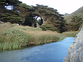 Pfeiffer Beach at the mouth of the Big Sur River in Pfeiffer Big Sur State Park, Big Sur, California | |
 | |
| Location | Monterey County, California, United States |
| Nearest city | Big Sur, California |
| Coordinates | 36°15′N 121°47′W / 36.250°N 121.783°WCoordinates: 36°15′N 121°47′W / 36.250°N 121.783°W |
| Area | 1,000 acres (4.0 km2) |
| Governing body | California Department of Parks and Recreation |


Pfeiffer Big Sur State Park is a state park in Monterey County, California, near the area of Big Sur on the state's Central Coast. It covers approximately 1,006 acres (4.07 km2) of land. The park is centered on the Big Sur River. It has been nicknamed a "mini Yosemite."[1] Redwood trees are known to live up to 2,200 years. A tree in the park nicknamed the Colonial Tree is estimated to be between 1,100 and 1,200 years old.[2]
History[]

The first known European settler in Big Sur was George Davis, who in 1853 claimed a tract of land along the Big Sur River. He built a cabin near the present day site of the beginning of the Mount Manuel Trail.[3]:326 In 1868, Native Americans Manual and Florence Innocenti bought Davis' cabin and land for $50.
Pfeiffer Big Sur State Park is named after John Pfeiffer, who lived in a cabin on the property beginning in 1884. He was the son of Michael Pfeiffer and Barbara Laquet. The Pfeiffer family immigrated from France. Their son and his family were among the first European settlers in the area. In the winter of 1869, Michael and Barbara Laquet Pfeiffer were on their way to the south coast of Big Sur when they were forced to stop for the season in the Sycamore Canyon area near present-day Big Sur Village. They liked the area so much they decided against moving south again the following spring. They brought four children with them: Charles, John, Mary Ellen, and Julia. They later had four more: William, Frank, Flora, and Adelaide. After the Homestead Act of 1862 was passed by Congress, he filed for patents on his land in 1883 and 1889.[4][5] Many features in Big Sur are named for the descendants of the Pfeiffers.
In 1930, John Pfeiffer was offered $210,000 for his land by a Los Angeles developer who intended to build a subdivision. Pfeiffer wanted to preserve the land he and his family had grown to love, and instead sold 700 acres (2.8 km2) to the state of California in 1933.[6]
In 1934, the Monterey Bay Area Council built a makeshift Camp Wing within the park, but it was abandoned after the 1937 summer camping season. The next year the Boy Scouts built Camp Esselen at another location within the park. This site was improved until 1945, when limitations of the site, closeness to public camping facilities, and jurisdictional conflicts between the Scouts and the state forced the council to request reimbursement from the state for $8,000 in improvements. The council continued to use the camp until 1953. In 1952, the Scouts began building Camp Pico Blanco, and when that camp was opened in 1954, Camp Esselen was finally closed.[7][8]
Overnight stays[]
Pfeiffer Big Sur State Park has both a hotel (the Big Sur Lodge) and a campground within its boundaries. The campgrounds were closed in the winter of 2008–2009 due to the Basin Complex Fire. The campgrounds have coin-operated showers, bathrooms and a convenience store.[9] The convenience store also offers WiFi access.[10]
Hiking[]
Pfeiffer Big Sur State Park is known for its redwood groves[11] and trail to Pfeiffer Falls. Mud slides caused by the Basin Complex fire necessitated rerouting the Pfeiffer Falls Trail, re-opened 13 years later in 2021.
Fire impact[]
Pfeiffer Big Sur State Park was damaged by the Basin Complex Fire during June and July 2008, which burned 162,818 acres (658.90 km2) in California.[12] Much of the damage was to the outskirts of the park, however, and the campgrounds were able to reopen at the end of July. The Chalk Fire of September and October, which burned an additional 16,269 acres (65.84 km2), did serious damage to Pfeiffer Big Sur State Park, which was largely closed from September 2008 to May 2009.[13]
References[]
- ^ "Pfeiffer Big Sur State Park".
- ^ Cannon, Rick. "A peek at the best places to commune with the county's incomparable California redwoods". Monterey County Weekly. Retrieved 15 June 2020.
- ^ Henson, Paul; Donald J. Usner (1993). "The Natural History of Big Sur" (PDF). University Of California Press. Archived from the original (PDF) on June 17, 2010. Retrieved 12 August 2016.
- ^ "Micheal Pfeiffer of Monterey County | 2 Land Patents". The Land Patents. Retrieved 16 April 2020.
- ^ "Hiking in Big Sur - Oak Grove Trail Loop". HikingInBigSur.com.
- ^ Heid, Analise Elliot (2013). Hiking & backpacking Big Sur : a complete guide to the trails of Big Sur, Ventana Wilderness, and Silver Peak Wilderness (Second ed.). Wilderness Press. p. 84. ISBN 978-0899977270.
- ^ "2017 Camp Pico Blanco Scout Reservation Leader's Guide". Salinas, California: Monterey Bay Area Council, Boy Scouts of America. Archived from the original on September 6, 2016. Retrieved September 5, 2016.
- ^ Young, Alfred (July 1963). "The Making of Men" (PDF). Salinas, California: Monterey Bay Area Council. Archived (PDF) from the original on December 1, 2010. Retrieved August 13, 2009.
- ^ "Pfeiffer Big Sur State Park".
- ^ "California State Parks: Pfeiffer Big Sur State Park".
- ^ Fodor's (21 December 2010). Fodor's Northern California 2011: With Napa, Sonoma, Yosemite, San Francisco & Lake Tahoe. Random House Digital, Inc. p. 94. ISBN 978-1-4000-0503-1. Retrieved 25 December 2011.
- ^ "InciWeb the Incident Information System: Basin Complex". InciWeb.nwcg.gov. Retrieved March 24, 2017.
- ^ "InciWeb the Incident Information System: Chalk". InciWeb.nwcg.gov. October 30, 2008. Retrieved March 24, 2017.
External links[]
| show Authority control |
|---|
- IUCN Category III
- State parks of California
- 1933 establishments in California
- Coast redwood groves
- Parks in Monterey County, California
- Protected areas established in 1933
- Santa Lucia Range
- Big Sur