Birdlip
| Birdlip | |
|---|---|
 Birdlip Primary School | |
 Birdlip Location within Gloucestershire | |
| OS grid reference | SO9214 |
| Civil parish | |
| District |
|
| Shire county | |
| Ceremonial county | |
| Region | |
| Country | England |
| Sovereign state | United Kingdom |
| Post town | Gloucester |
| Postcode district | GL4 |
| Dialling code | 01452 |
| Police | Gloucestershire |
| Fire | Gloucestershire |
| Ambulance | South Western |
| UK Parliament |
|

Birdlip is a village in Cotswold District of Gloucestershire in England,[1] in the Cotswolds Area of Outstanding Natural Beauty, at an altitude of 287 m (940 ft), and about 6 miles (9.7 km) south of Cheltenham and 8 miles (13 km) south east of Gloucester.[2]
History[]
Some fine pre-Roman bronze art, including the famous Birdlip Mirror, from around AD 50, was found at Barrow Wake near Birdlip.[3][4]
The village was once on the main road between Gloucester and Cirencester, now the A417. The building of a bypass, which opened in December 1988, moved the main route away from the village.[5][6]
Black Horse Ridge is a 17th-century building that until 1900 was a public house.[7] A lodge adjacent to Black Horse Ridge was designed by Richard Pace and built in 1822.[7] Birdlip's remaining pub is The Royal George Hotel, which was built in the 19th century.[7]
Birdlip House is a Georgian house built late in the 18th century.[7]
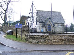
The Church of England parish church of Saint Mary burned down in 1897, and was replaced in 1957 by a new church designed by the architect Harold Stratton-Davis. It was a small tin church with green painting. [7]
Amenities[]
Birdlip has a community primary school.
Birdlip is on the Cotswold Way, a National Trail running along the edge of The Cotswolds AONB. The view from Barrow Wake viewpoint in the village takes in much of the Vale of Gloucester.[8]
Located next to the primary school is Birdlip and Brimpsfield Cricket Club (BBCC). The club has three senior teams, playing on Wednesdays and Saturdays. BBCC is famous for once fielding a team made entirely of members of the Partridge family.
Birdlip had an infamous "Dogging Area" at the Barrow Wake viewpoint.[9]
Sources[]
- Verey, David (1970). The Buildings of England: Gloucestershire: The Cotswolds. Harmondsworth: Penguin Books. pp. 112–113. ISBN 0-14-071040-X.
References[]
- ^ "Birdlip location and weather". Falling Rain Genomics. Retrieved 19 March 2011.
- ^ "Guide to Birdlip". Information Britain. Retrieved 3 April 2009.
- ^ "The Birdlip Mirror". BBC- A History of the World. Retrieved 10 March 2016.
- ^ Verey, 1970, page 113
- ^ "Transport Written Answers: 26 November 1986". Hansard. Retrieved 10 March 2016.
- ^ "Transport Written Answers: 11 July 1990". Hansard. Retrieved 10 March 2016.
- ^ a b c d e Verey, 1970, page 112
- ^ "View from Barrow Wake viewpoint". Panoramio. Archived from the original on 21 June 2017. Retrieved 3 April 2009.
- ^ "Fake sign promotes Cotswold viewpoint as 'dogging' area". BBC News. 4 May 2010. Retrieved 1 April 2011.
External links[]
![]() Media related to Birdlip at Wikimedia Commons
Media related to Birdlip at Wikimedia Commons
- Villages in Gloucestershire
- Cotswold District