Bishop Creek (Inyo County)
| Bishop Creek | |
|---|---|
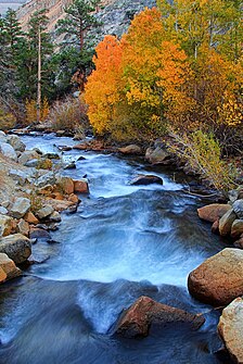 North Fork Bishop Creek in the Fall | |
| Physical characteristics | |
| Source | |
| • coordinates | 37°15′57″N 118°34′41″W / 37.26583°N 118.57806°W |
| • elevation | 7,400 feet (2,300 m) |
| Mouth | |
• location | Owens River |
• elevation | 4,482 feet (1,366 m) |
| Discharge | |
| • average | 95 cubic feet per second (2.7 m3/s) |

- Bishop Creek is also a dated variant of Baxter Creek in Richmond/El Cerrito, California
Bishop Creek is a 10.1-mile-long (16.3 km)[1] stream in Inyo County, California. It is the largest tributary of the Owens River. It has five hydroelectric plants owned by Southern California Edison, Bishop Creek #2–6. Bishop Creek #1 was never completed. Parts of the creek run through pipelines, or penstocks, to increase output at the power plants.
Bishop Creek has three forks, North, Middle and South. All have their headwaters in the eastern Sierra Nevada, near the border with Fresno County. The forks all flow into lakes while still at high elevations. The North Fork flows into , the Middle Fork flows into Lake Sabrina. The North and Middle forks combine above and flow through the community of Aspendell and below it the combined creeks are dammed at Intake Two, a reservoir. The South Fork flows into and continues through the community of South Fork (aka Habegger's) and then joins the Middle Fork below the Intake Two reservoir. Bishop Creek then begins its steep descent to the Owens Valley. The creek runs roughly North then Northeast and then continues East, flowing past the city of Bishop before its confluence with the Owens River.
The creek was named after Owens Valley settler Samuel Addison Bishop.[2]
See also[]
References[]
- ^ U.S. Geological Survey. National Hydrography Dataset high-resolution flowline data. The National Map Archived 2012-04-05 at WebCite, accessed March 17, 2011
- ^ Browning, Peter (2005). Yosemite Place Names: The Historic Background of Geographic Names in Yosemite National Park. Great West Books. p. 13. ISBN 978-0-94422-019-1.
External links[]
| Wikimedia Commons has media related to: Bishop Creek (category) |
- "Bishop Creek". Geographic Names Information System. United States Geological Survey.
- United States Geological Survey
- Mono Basin Clearinghouse
Coordinates: 37°18′18″N 118°31′53″W / 37.304918°N 118.531494°W
This Inyo County, California-related article is a stub. You can help Wikipedia by . |
- Rivers of Inyo County, California
- Rivers of the Sierra Nevada (United States)
- Tributaries of the Owens River
- Inyo National Forest
- Bishop, California
- Owens Valley
- Rivers of Northern California
- Rivers of the Sierra Nevada in California
- Inyo County, California geography stubs
- California river stubs