Lake


A lake is an area filled with water, localized in a basin, surrounded by land, apart from any river or other outlet that serves to feed or drain the lake.[1] Lakes lie on land and are not part of the ocean, although like the much larger oceans, they form part of Earth's water cycle. Lakes are distinct from lagoons which are generally coastal parts of the ocean. They are generally larger and deeper than ponds, which also lie on land, though there are no official or scientific definitions.[2] Lakes can be contrasted with rivers or streams, which are usually flowing in a channel on land. Most lakes are fed and drained by rivers and streams.[3]
Natural lakes are generally found in mountainous areas, rift zones, and areas with ongoing glaciation. Other lakes are found in endorheic basins or along the courses of mature rivers, where a river channel has widened into a basin. In some parts of the world there are many lakes because of chaotic drainage patterns left over from the last Ice Age. All lakes are temporary over geologic time scales, as they will slowly fill in with sediments or spill out of the basin containing them.
Many lakes are artificial and are constructed for industrial or agricultural use, for hydro-electric power generation or domestic water supply, or for aesthetic, recreational purposes, or other activities.
Etymology, meaning, and usage of "lake"


The word lake comes from Middle English lake ('lake, pond, waterway'), from Old English lacu ('pond, pool, stream'), from Proto-Germanic *lakō ('pond, ditch, slow moving stream'), from the Proto-Indo-European root *leǵ- ('to leak, drain'). Cognates include Dutch laak ('lake, pond, ditch'), Middle Low German lāke ('water pooled in a riverbed, puddle') as in: de:Wolfslake, de:Butterlake, German Lache ('pool, puddle'), and Icelandic lækur ('slow flowing stream'). Also related are the English words leak and leach.
There is considerable uncertainty about defining the difference between lakes and ponds, and no current internationally accepted definition of either term across scientific disciplines or political boundaries exists.[4] For example, limnologists have defined lakes as water bodies which are simply a larger version of a pond, which can have wave action on the shoreline or where wind-induced turbulence plays a major role in mixing the water column. None of these definitions completely excludes ponds and all are difficult to measure. For this reason, simple size-based definitions are increasingly used to separate ponds and lakes. Definitions for lake range in minimum sizes for a body of water from 2 hectares (5 acres)[5]:331[6] to 8 hectares (20 acres)[7] (see also the definition of "pond"). Charles Elton, one of the founders of ecology, regarded lakes as waterbodies of 40 hectares (99 acres) or more.[8] The term lake is also used to describe a feature such as Lake Eyre, which is a dry basin most of the time but may become filled under seasonal conditions of heavy rainfall. In common usage, many lakes bear names ending with the word pond, and a lesser number of names ending with lake are in quasi-technical fact, ponds. One textbook illustrates this point with the following: "In Newfoundland, for example, almost every lake is called a pond, whereas in Wisconsin, almost every pond is called a lake."[9]
One hydrology book proposes to define the term "lake" as a body of water with the following five characteristics:[4]
- it partially or totally fills one or several basins connected by straits
- has essentially the same water level in all parts (except for relatively short-lived variations caused by wind, varying ice cover, large inflows, etc.)
- it does not have regular intrusion of seawater
- a considerable portion of the sediment suspended in the water is captured by the basins (for this to happen they need to have a sufficiently small inflow-to-volume ratio)
- the area measured at the mean water level exceeds an arbitrarily chosen threshold (for instance, one hectare)
With the exception of the seawater intrusion criterion, the others have been accepted or elaborated upon by other hydrology publications.[10][11]

Distribution

The majority of lakes on Earth are freshwater, and most lie in the Northern Hemisphere at higher latitudes.[12] Canada, with a deranged drainage system, has an estimated 31,752 lakes larger than 3 square kilometres (1.2 sq mi)[13] and an unknown total number of lakes, but is estimated to be at least 2 million.[14] Finland has 187,888 lakes 500 square metres (5,400 sq ft) or larger, of which 56,000 are large (10,000 square metres (110,000 sq ft) or larger).[15]
Most lakes have at least one natural outflow in the form of a river or stream, which maintain a lake's average level by allowing the drainage of excess water.[3][16] Some lakes do not have a natural outflow and lose water solely by evaporation or underground seepage or both. They are termed endorheic lakes.
Many lakes are artificial and are constructed for hydro-electric power generation, aesthetic purposes, recreational purposes, industrial use, agricultural use or domestic water supply.
The number of lakes on Earth is highly uncertain because most lakes and ponds (see definition of ponds) are very small and do not appear on maps or satellite imagery.[17][18][19][20] Despite this uncertainty, a large number of studies agree that small ponds are much more abundant than large lakes. For example, one widely cited study estimated that Earth has 304 million lakes and ponds, and that 91% of these are 1 hectare (2.5 acres) or less in area.[17] Despite the overwhelming abundance of ponds, almost all of Earth's lake water is found in less than 100 large lakes.[21] This is because lake volume scales superlinearly with lake area.[22]
Evidence of extraterrestrial lakes exists; "definitive evidence for the presence of lakes" was announced by NASA as returned by the Cassini Probe observing the moon Titan, which orbited the planet Saturn.[23] The distribution and shape of lakes on Titan is very similar to lakes on Earth.[24][25][26] Lakes were formerly present on the surface of Mars, but are now dry lake beds.[27][18][28][29]
Types

In 1957, Hutchinson[30] published a monograph that is regarded as a landmark discussion and classification of all major lake types, their origin, morphometric characteristics, and distribution.[31][32][33] Hutchinson presented in it a comprehensive analysis of the origin of lakes and proposed what is a widely accepted classification of lakes according to their origin. This classification recognizes 11 major lake types that are divided into 76 subtypes. The 11 major lake types are tectonic lakes, volcanic lakes, landslide lakes, glacial lakes, solution lakes, fluvial lakes, aeolian lakes, shoreline lakes, organic lakes, anthropogenic lakes, and meteorite (extraterrestrial impact) lakes.[32][31][33]
Tectonic lakes
Tectonic lakes are lakes formed by the deformation and resulting lateral and vertical movements of the Earth's crust. These movements include faulting, tilting, folding, and warping. Some of the well-known and largest lakes on Earth are rift lakes occupying rift valleys, e.g. Central African Rift lakes and Lake Baikal. Other well-known tectonic lakes, Caspian Sea, the Sea of Aral, and other lakes from the Pontocaspian occupy basins that have been separated from the sea by the tectonic uplift of the sea floor above sea level.[30][32][31][33]
Often, the tectonic action of crustal extension has created an alternating series of parallel grabens and horsts that form elongate basins alternating with mountain ranges. Not only does this promote the creation of lakes by the disruption of preexisting drainage networks, it also creates within arid regions endorheic basins that containing salt lakes (also called saline lakes). They form where there is no natural outlet, a high evaporation rate and the drainage surface of the water table has a higher-than-normal salt content. Examples of these salt lakes include Great Salt Lake and the Dead Sea. Another type of tectonic lake caused by faulting is sag ponds.[30][32][31][33]
Volcanic lakes

Volcanic lakes are lakes that occupy either local depressions, e.g. craters and maars or larger basins, e.g. calderas, created by volcanism. Crater lakes are formed in volcanic craters and calderas, which fill up with precipitation more rapidly than they empty via either evaporation, groundwater discharge, or combination of both. Sometimes the latter are called caldera lakes, although often no distinction is made. An example is Crater Lake in Oregon, in the caldera of Mount Mazama. The caldera was created in a massive volcanic eruption that led to the subsidence of Mount Mazama around 4860 BCE. Other volcanic lakes are created when either rivers or streams are dammed by lava flows or volcanic lahars.[30][32][31][33] The basin which is now Malheur Lake, Oregon was created when a lava flow dammed the Malheur River.[34] Among all lake types, volcanic crater lakes most closely approximate a circular shape.[3]
Glacial lakes

Glacial lakes are lakes created by the direct action of glaciers and continental ice sheets. A wide variety of glacial processes create enclosed basins. As a result, there are a wide variety of different types of glacial lakes and it is often difficult to define clear-cut distinctions between different types of glacial lakes and lakes influenced by other activities. The general types of glacial lakes that have recognized are lakes in direct contact with ice; glacially carved rock basins and depressions; morainic and outwash lakes; and glacial drift basins. Glacial lakes are the most numerous lakes in the world. Most lakes in northern Europe and North America have been either influenced or created by the latest, but not last, glaciation, to have covered the region.[30][32][31][33] Glacial lakes include proglacial lakes, subglacial lakes, finger lakes, and epishelf lakes. Epishelf lakes are highly stratified lakes in which a layer of freshwater, derived from ice and snow melt, is dammed behind an ice shelf that is attached to the coastline. They are mostly found in Antarctica.[35]
Fluvial lakes
Fluvial (or riverine)[36] lakes are lakes produced by running water. These lakes include plunge pool lakes, fluviatile dams and meander lakes.
Oxbow lakes
The most common type of fluvial lake is a crescent-shaped lake called an oxbow lake due to the distinctive curved shape. They can form in river valleys as a result of meandering. The slow-moving river forms a sinuous shape as the outer side of bends are eroded away more rapidly than the inner side. Eventually a horseshoe bend is formed and the river cuts through the narrow neck. This new passage then forms the main passage for the river and the ends of the bend become silted up, thus forming a bow-shaped lake.[30][31][32][33] Their crescent shape gives oxbow lakes a higher perimeter to area ratio than other lake types.[3]
Fluviatile dams
These form where sediment from a tributary blocks the main river.[37]
Lateral lakes
These form where sediment from the main river blocks a tributary, usually in the form of a levee.[36]
Solution lakes
A solution lake is a lake occupying a basin formed by surface dissolution of bedrock. In areas underlain by soluble bedrock, its solution by precipitation and percolating water commonly produce cavities. These cavities frequently collapse to form sinkholes that form part of the local karst topography. Where groundwater lies near the grounds surface, a sinkhole will be filled water as a solution lake.[30][32] If such a lake consists of a large area of standing water that occupies an extensive closed depression in limestone, it is also called a karst lake. Smaller solution lakes that consist of a body of standing water in a closed depression within a karst region are known as karst ponds.[38] Limestone caves often contain pools of standing water, which are known as underground lakes. Classic examples of solution lakes are abundant in the karst regions at the Dalmatian coast of Croatia and within large parts of Florida.[30]
Landslide lakes
Landslide lakes are lakes created by the blockage of a valley by either mudflows, rockslides, or screes. Such lakes are common in mountainous regions. Although landslide lakes may be large and quite deep, they are typically short-lived.[30][32][31][33] An example of a landslide lake is Quake Lake, which formed as a result of the 1959 Hebgen Lake earthquake.[39]
Aeolian lakes
Aeolian lakes are lakes produced by wind action. They are found mainly in arid environments although some aeolian lakes are relict landforms indicative of arid paleoclimates. Aeolian lakes consist of lake basins dammed by wind-blown sand; interdunal lakes that lies between well-oriented sand dunes; and deflation basins formed by wind action under previously arid paleoenvironments. Moses Lake, Washington, is an example of a lake basins dammed by wind-blown sand.[30][32][31][33]
Shoreline lakes
Shoreline lakes are generally lakes created by blockage of estuaries or by the uneven accretion of beach ridges by longshore and other currents. They include maritime coastal lakes, ordinarily in drowned estuaries; lakes enclosed by two tombolos or spits connecting an island to the mainland; lakes cut off from larger lakes by a bar; or lakes divided by the meeting of two spits.[30][32][31][33]
Organic lakes
Organic lakes are lakes created by the actions of plants and animals. On the whole they are relatively rare in occurrence and quite small in size. In addition, they typically ephemeral features relative to the other types of lakes. The basins in which organic lakes occur are associated with beaver dams, coral lakes, or dams formed by vegetation.[32][33]
Peat lakes
Peat lakes are a form of organic lake. They form where a buildup of partly decomposed plant material in a wet environment leaves the vegetated surface below the water table for a sustained period of time. They are often low in nutrients and mildly acidic, with bottom waters low in dissolved oxygen.[40]
Anthropogenic lakes
Anthropogenic lakes are artificially created lakes formed by human activity. They can be the result of intentional damming of rivers and streams or subsequent filling of abandoned excavations by either ground water, precipitation, or a combination of both.[32][33]
Meteorite (extraterrestrial impact/crater) lakes
Meteorite lakes, which are also known as crater lakes, are lakes created by catastrophic extraterrestrial impacts by either meteorites or asteroids.[30][32][33] Examples of meteorite lakes are Lonar crater lake, India,[41] Lake Elgygytgyn, Siberia,[42] and Pingualuit crater lake, Quebec, Canada,[43] As in case of Lake El'gygytgyn and Pingualuit crater lake, meteorite (extraterrestrial impact/ crater) lakes can contain unique and scientifically valuable sedimentary deposits associated with long records of paleoclimatic changes.[42][43]
Other types


In addition to mode of origin, lakes have been named and classified in various other ways according to their thermal stratification, salinity, relative seasonal permanence, degree of outflow, and other factors. Also, different cultures and regional of the world have their popular nomenclature
Types of lakes according to thermal stratification
In addition to their origin, there are various other ways of either naming or defining types of lakes. One major way of classification lakes in on the basis of thermal stratification because it is a major control on animal and plant life inhabiting a lake and the fate and distribution of dissolved and suspended material in a lake. For example, the thermal stratification and the degree and frequency of mixing exerts a strong control on the distribution of oxygen within it. In addition, lake can be classified according to important factors such as seasonal variations in lake volume and level, oxygen saturation, and salinity of its water mass. Finally, the names of types of lakes that are used by the lay public and in the scientific for different types of lakes are often informally derived from either from their morphology of other aspects or their physical characteristics.
F.A. Forel,[44] who is also referred to as the father of limnology, was the first scientist to classify lakes according to their thermal stratification.[45] His system of classification was later modified and improved upon by Hutchinson and Laffler.[46] Because the density of water varies with temperature, with a maximum at +4 DC, thermal stratification is an important physical characteristic of lakes that controls the fauna and flora, sedimentation, chemistry, and other aspects of individual lakes. First, the colder, heavier water typically forms a layer near the bottom, which called the hypolimnion. Second, normally overlying it is a transition zone known as the metalimnion. Finally, overlying the metalimnion is a surface layer of a warmer, lighter water is called the epilimnion. However, this typical stratification sequence can vary widely depending either on the specific lake, the time of season, or combination of both.[32][45][46]
Based upon thermal stratification, lakes are classified as either holomictic lakes or meromictic lakes. A meromictic lake is a lake which has layers of water which do not intermix. The deepest layer of water in such a lake does not contain any dissolved oxygen. In addition, the layers of sediment at the bottom of a meromictic lake remain relatively undisturbed because there are no living aerobic organisms. The lack of disturbance allows for the development of lacustrine varves. A Holomictic lake is a lake that has a uniform temperature and density from top to bottom at a specific time during the year. This uniformity temperature and density in allows the lake waters to completely mix. Holomictic lakes are non-meromictic lakes. Based upon thermal stratification and frequency of turnover, holomictic lakes are divided into amictic lakes, cold monomictic lakes, dimictic lakes, warm monomictic lakes, polymictic lakes, and oligomictic lakes. The classification of lakes by thermal stratification presupposes lakes with sufficient depth to form a hypolimnion. As a results, very shallow lakes are excluded this classification system.[32][46]
The stratification in a lake is not always the result of variation to density because of thermal gradients. Stratification within a lake can also be the result of differences in density resulting from gradients in salinity. In case of a difference in salinity, the hypolimnion and epilimnion are separated not by a thermocline but by a halocline, which is sometimes referred to as a chemocline.[32][46]
Types of lake according to seasonal variation of lake level and volume
Lakes are informally classified and named according to the seasonal variation in their lake level and volume. Some of the names include:
- Ephemeral lake is a short-lived lake or pond.[47] If it fills with water and dries up (disappears) seasonally it is known as an intermittent lake[48] They often fill poljes.[49]
- Dry lake is a popular name for an ephemeral lake that contains water only intermediately at irregular and infrequent intervals.[38][50]
- Perennial lake is a lake that has water in its basin throughout the year and is not subject to extreme fluctuations in level.[38][47]
- Playa lake is a typically shallow, intermittent lake that covers or occupies a playa either in wet seasons or in especially wet years but subsequently drying up in an arid or semiarid region.[38][50]
- Vlei is a name used in South Africa for a shallow lake which varies considerably in level with the seasons.[51]
Types of lake according to water chemistry
Lakes are also informally classified and named according to the general chemistry of their water mass. Some of the types of lakes include:
- An acid lake is a lake that has a pH is below neutral (<6.5). A lake is considered highly acidic when the pH drops below 5.5, below which when biological consequences occur. Such lakes include acid pit lakes occupying abandoned mines and excavations; naturally acid lakes of igneous and metamorphic landscapes; peat bogs in northern regions; acid-saline lakes of arid environments; crater lakes of active and dormant volcanoes; and lakes acidified by acid rain.[52][53][54]
- A salt lake, which also known as a brine lake, is an inland body of water situated in an arid or semiarid region, having no outlet to the sea, and containing a high concentration of dissolved salts (principally sodium chloride). Examples include the Great Salt Lake in Utah, and the Dead Sea in the Near East.[38][50]
- Alkali sink, also known as salt flats, are lakes on the other extreme of the scale from the large and deep saline lakes. They are, shallow saline features that occupy low-lying areas of the arid regions and in groundwater discharge zones. These are typically classifiable as either playas or playa lakes because they are periodically flooded by either rain or flood events and then dry up during drier intervals, leaving accumulations of brines and evaporitic minerals.[38][50]
- A salt pan (saltpan) is either an undrained small shallow natural depression in which water accumulates and evaporates leaving a salt deposit or the shallow lake of brackish water occupying a salt pan. This term is also used for a large pan for recovering salt by evaporation.[38]
- A saline pan is a name for an ephemeral saline lake which precipitates a bottom crust that is subsequently modified during subaerial exposure.[38]
Lakes composed of other liquids
- Lava lake is a large volume of molten lava, usually basaltic, contained in a volcanic vent, crater, or broad depression.[55]
- Hydrocarbon lakes are bodies of liquid ethane and methane that occupy depressions on the surface of Titan. They were detected by the Cassini–Huygens space probe.[56]
Paleolakes
A paleolake, also spelt palaeolake, is a lake that existed in the past when hydrological conditions were different.[57] Quaternary paleolakes can often be identified on the basis of relict lacustrine landforms such as relict lake plains and coastal landforms that form recognizable relict shorelines, which are called paleoshorelines. Paleolakes can also be recognized by characteristic sedimentary deposits that accumulated in them and any fossils that these sediments might contain. The paleoshorelines and sedimentary deposits of paleolakes provide evidence for prehistoric hydrological changes during the times that they existed.[57][58]
Types of paleolakes include:
- A former lake is a lake which is no longer in existence. Such lakes include prehistoric lakes and lakes which have permanently dried up often as the result of either evaporation or human intervention. Owens Lake in California, USA, is an example of a former lake. Former lakes are a common feature of the Basin and Range area of southwestern North America.[59]
- A shrunken lake is a lake which has drastically decreased in size over geological time. Lake Agassiz, which once covered much of central North America, is a good example of a shrunken lake. Two notable remnants of this lake are Lake Winnipeg and Lake Winnipegosis.[59]
Paleolakes are of scientific and economic importance. For example, Quaternary paleolakes in semidesert basins are important for two reasons. First, they played an extremely significant, if transient, role in shaping the floors and piedmonts of many basins. Finally, their sediments contain enormous quantities of geologic and paleontologic information concerning past environments.[60] In addition, the organic-rich deposits of pre-Quaternary paleolakes are important either for the thick deposits of oil shale and shale gas that they contain or as source rocks of petroleum and natural gas. Although of significantly less economic importance, strata deposited along the shore of paleolakes sometimes contain coal seams.[61][62]
Characteristics
This section needs additional citations for verification. (October 2020) |

Lakes have numerous features in addition to lake type, such as drainage basin (also known as catchment area), inflow and outflow, nutrient content, dissolved oxygen, pollutants, pH, and sedimentation.
Changes in the level of a lake are controlled by the difference between the input and output compared to the total volume of the lake. Significant input sources are precipitation onto the lake, runoff carried by streams and channels from the lake's catchment area, groundwater channels and aquifers, and artificial sources from outside the catchment area. Output sources are evaporation from the lake, surface and groundwater flows, and any extraction of lake water by humans. As climate conditions and human water requirements vary, these will create fluctuations in the lake level.
Lakes can be also categorized on the basis of their richness in nutrients, which typically affect plant growth. Nutrient-poor lakes are said to be oligotrophic and are generally clear, having a low concentration of plant life. Mesotrophic lakes have good clarity and an average level of nutrients. Eutrophic lakes are enriched with nutrients, resulting in good plant growth and possible algal blooms. Hypertrophic lakes are bodies of water that have been excessively enriched with nutrients. These lakes typically have poor clarity and are subject to devastating algal blooms. Lakes typically reach this condition due to human activities, such as heavy use of fertilizers in the lake catchment area. Such lakes are of little use to humans and have a poor ecosystem due to decreased dissolved oxygen.
Due to the unusual relationship between water's temperature and its density, lakes form layers called thermoclines, layers of drastically varying temperature relative to depth. Fresh water is most dense at about 4 degrees Celsius (39.2 °F) at sea level. When the temperature of the water at the surface of a lake reaches the same temperature as deeper water, as it does during the cooler months in temperate climates, the water in the lake can mix, bringing oxygen-starved water up from the depths and bringing oxygen down to decomposing sediments. Deep temperate lakes can maintain a reservoir of cold water year-round, which allows some cities to tap that reservoir for deep lake water cooling.
Since the surface water of deep tropical lakes never reaches the temperature of maximum density, there is no process that makes the water mix. The deeper layer becomes oxygen starved and can become saturated with carbon dioxide, or other gases such as sulfur dioxide if there is even a trace of volcanic activity. Exceptional events, such as earthquakes or landslides, can cause mixing which rapidly brings the deep layers up to the surface and release a vast cloud of gas which lay trapped in solution in the colder water at the bottom of the lake. This is called a limnic eruption. An example is the disaster at Lake Nyos in Cameroon. The amount of gas that can be dissolved in water is directly related to pressure. As deep water surfaces, the pressure drops and a vast amount of gas comes out of solution. Under these circumstances carbon dioxide is hazardous because it is heavier than air and displaces it, so it may flow down a river valley to human settlements and cause mass asphyxiation.
The material at the bottom of a lake, or lake bed, may be composed of a wide variety of inorganics, such as silt or sand, and organic material, such as decaying plant or animal matter. The composition of the lake bed has a significant impact on the flora and fauna found within the lake's environs by contributing to the amounts and the types of nutrients available.
A paired (black and white) layer of the varved lake sediments correspond to a year. During winter, when organisms die, carbon is deposited down, resulting to a black layer. At the same year, during summer, only few organic materials are deposited, resulting to a white layer at the lake bed. These are commonly used to track past paleontological events.
Natural lakes provide a microcosm of living and nonliving elements that are relatively independent of their surrounding environments. Therefore, lake organisms can often be studied in isolation from the lake's surroundings.[64]
Limnology

Limnology is the study of inland bodies of water and related ecosystems. Limnology divides lakes into three zones: the littoral zone, a sloped area close to land; the photic or open-water zone, where sunlight is abundant; and the deep-water profundal or benthic zone, where little sunlight can reach. The depth to which light can reach in lakes depends on turbidity, determined by the density and size of suspended particles. A particle is in suspension if its weight is less than the random turbidity forces acting upon it. These particles can be sedimentary or biological in origin and are responsible for the color of the water. Decaying plant matter, for instance, may be responsible for a yellow or brown color, while algae may cause greenish water. In very shallow water bodies, iron oxides make water reddish brown. Biological particles include algae and detritus. Bottom-dwelling detritivorous fish can be responsible for turbid waters, because they stir the mud in search of food. Piscivorous fish contribute to turbidity by eating plant-eating (planktonivorous) fish, thus increasing the amount of algae (see aquatic trophic cascade). The light depth or transparency is measured by using a Secchi disk, a 20-cm (8 in) disk with alternating white and black quadrants. The depth at which the disk is no longer visible is the Secchi depth, a measure of transparency. The Secchi disk is commonly used to test for eutrophication. For a detailed look at these processes, see lentic ecosystems.
A lake moderates the surrounding region's temperature and climate because water has a very high specific heat capacity (4,186 J·kg−1·K−1). In the daytime a lake can cool the land beside it with local winds, resulting in a sea breeze; in the night it can warm it with a land breeze.
Biological Properties

Lake zones:
- Epilittoral: Zone above water level entirely that is never touched by water levels.
- Littoral: Zone which encompasses from the small area above the normal water line that is sometimes touched by increasing water levels to the deepest part of the lake that still allows for submerged macrophytic growth.
- Littoriprofundal: A transition zone that is commonly aligned with stratified lakes’ metalimnions, this zone is too deep for macrophytes but includes photosynthetic algae and bacteria.
- Profundal: Sedimentary zone which does not contain any vegetation.
Algal community types:
- Epipelic: Algae which grows on sediments.
- Epilithic: Algae which grows on top of rock.
- Epipsammic: Algae growing on or within sand.
- Epiphytic: Algae growing on macrophytes.
- Epizooic: Algae growing on animals.
- Metaphyton: Algae present in the littoral zone that is not in a state of suspension nor attached to a substratum (such as a macrophyte).[65]
Circulation
This section is empty. You can help by . (October 2020) |
Flora and fauna
This section is empty. You can help by . (October 2020) |
Disappearance


The lake may be infilled with deposited sediment and gradually become a wetland such as a swamp or marsh. Large water plants, typically reeds, accelerate this closing process significantly because they partially decompose to form peat soils that fill the shallows. Conversely, peat soils in a marsh can naturally burn and reverse this process to recreate a shallow lake resulting in a dynamic equilibrium between marsh and lake.[66] This is significant since wildfire has been largely suppressed in the developed world over the past century. This has artificially converted many shallow lakes into emergent marshes. Turbid lakes and lakes with many plant-eating fish tend to disappear more slowly. A "disappearing" lake (barely noticeable on a human timescale) typically has extensive plant mats at the water's edge. These become a new habitat for other plants, like peat moss when conditions are right, and animals, many of which are very rare. Gradually, the lake closes and young peat may form, forming a fen. In lowland river valleys where a river can meander, the presence of peat is explained by the infilling of historical oxbow lakes. In the final stages of succession, trees can grow in, eventually turning the wetland into a forest.
Some lakes can disappear seasonally. These are called intermittent lakes, ephemeral lakes, or seasonal lakes and can be found in karstic terrain. A prime example of an intermittent lake is Lake Cerknica in Slovenia or Lag Prau Pulte in Graubünden. Other intermittent lakes are only the result of above-average precipitation in a closed, or endorheic basin, usually filling dry lake beds. This can occur in some of the driest places on earth, like Death Valley. This occurred in the spring of 2005, after unusually heavy rains.[67] The lake did not last into the summer, and was quickly evaporated (see photos to right). A more commonly filled lake of this type is Sevier Lake of west-central Utah.
Sometimes a lake will disappear quickly. On 3 June 2005, in Nizhny Novgorod Oblast, Russia, a lake called Lake Beloye vanished in a matter of minutes. News sources reported that government officials theorized that this strange phenomenon may have been caused by a shift in the soil underneath the lake that allowed its water to drain through channels leading to the Oka River.[68]
The presence of ground permafrost is important to the persistence of some lakes. Thawing permafrost may explain the shrinking or disappearance of hundreds of large Arctic lakes across western Siberia. The idea here is that rising air and soil temperatures thaw permafrost, allowing the lakes to drain away into the ground.[69]
Some lakes disappear because of human development factors. The shrinking Aral Sea is described as being "murdered" by the diversion for irrigation of the rivers feeding it.
Extraterrestrial lakes
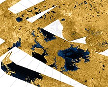
Only one world other than Earth is known to harbor large lakes, Saturn's largest moon, Titan. Photographs and spectroscopic analysis by the Cassini–Huygens spacecraft show liquid ethane on the surface, which is thought to be mixed with liquid methane. The largest Titanean lake, Kraken Mare at 400,000 km2, is three-times[citation needed] the size of any lake on Earth, and even the second, Ligeia Mare, is estimated to be slightly larger than Earth's Lake Michigan–Huron.
Jupiter's large moon Io is volcanically active, and as a result sulfur deposits have accumulated on the surface. Some photographs taken during the Galileo mission appear to show lakes of liquid sulfur in volcanic caldera, though these are more analogous to lake of lava than of water on Earth.[70]
The planet Mars has only one confirmed lake; it is underground and near the south pole.[71] However, the surface of Mars is too cold and has too little atmospheric pressure to permit permanent surface water. Geologic evidence appears to confirm, however, that ancient lakes once formed on the surface. It is also possible that volcanic activity on Mars will occasionally melt subsurface ice, creating large temporary lakes.[citation needed] This water would quickly freeze and then sublimate, unless insulated in some manner, such as by a coating of volcanic ash.
There are dark basaltic plains on the Moon, similar to lunar maria but smaller, that are called lacus (singular lacus, Latin for "lake") because they were thought by early astronomers to be lakes of water.
Notable lakes on Earth

- The largest lake by surface area is Caspian Sea, which is despite its name considered as a lake from the point of view of geography.[72] Its surface area is 143,000 sq. mi./371,000 km2.
- The second largest lake by surface area, and the largest freshwater lake by surface area, is Lake Michigan-Huron, which is hydrologically a single lake. Its surface area is 45,300 sq. mi./117,400 km2. For those who consider Lake Michigan-Huron to be separate lakes, and Caspian Sea to be a sea, Lake Superior would be the largest lake at 82,100 km2 (31,700 square miles)
- Lake Baikal is the deepest lake in the world, located in Siberia, with a bottom at 1,637 metres (5,371 ft). Its mean depth is also the greatest in the world (749 metres (2,457 ft)).
It is also the world's largest freshwater lake by volume (23,600 cubic kilometres (5,700 cu mi), but much smaller than the Caspian Sea at 78,200 cubic kilometres (18,800 cu mi)), and the second longest (about 630 kilometres (390 mi) from tip to tip). - The world's oldest lake is Lake Baikal, followed by Lake Tanganyika in Tanzania. Lake Maracaibo is considered by some to be the second-oldest lake on Earth, but since it lies at sea level and nowadays is a contiguous body of water with the sea, others consider that it has turned into a small bay.
- The longest lake is Lake Tanganyika, with a length of about 660 kilometres (410 mi) (measured along the lake's center line).
It is also the third largest by volume, the second oldest, and the second deepest (1,470 metres (4,820 ft)) in the world, after Lake Baikal. - The world's highest lake, if size is not a criterion, may be the crater lake of Ojos del Salado, at 6,390 metres (20,965 ft).[73]
- The highest large (greater than 250 square kilometres (97 sq mi)) lake in the world is the 290 square kilometres (110 sq mi)[citation needed] Pumoyong Tso (Pumuoyong Tso[citation needed]), in the Tibet Autonomous Region of China, at 28°34′N 90°24′E / 28.567°N 90.400°E, 5,018 metres (16,463 ft) above sea level.[74]
- The world's highest commercially navigable lake is Lake Titicaca in Peru and Bolivia at 3,812 m (12,507 ft). It is also the largest lake in South America.
- The world's lowest lake is the Dead Sea, bordered by Jordan to the east and Israel and Palestine to the west, at 418 metres (1,371 ft) below sea level. It is also one of the lakes with highest salt concentration.
- Lake Michigan–Huron has the longest lake coastline in the world: about 5,250 kilometres (3,260 mi), excluding the coastline of its many inner islands. Even if it is considered two lakes, Lake Huron alone would still have the longest coastline in the world at 2,980 kilometres (1,850 mi).
- The largest island in a lake is Manitoulin Island in Lake Michigan-Huron, with a surface area of 2,766 square kilometres (1,068 sq mi). Lake Manitou, on Manitoulin Island, is the largest lake on an island in a lake.
- The largest lake on an island is Nettilling Lake on Baffin Island, with an area of 5,542 square kilometres (2,140 sq mi) and a maximum length of 123 kilometres (76 mi).[75]
- The largest lake in the world that drains naturally in two directions is Wollaston Lake.
- Lake Toba on the island of Sumatra is in what is probably the largest resurgent caldera on Earth.
- The largest lake completely within the boundaries of a single city is Lake Wanapitei in the city of Sudbury, Ontario, Canada. Before the current city boundaries came into effect in 2001, this status was held by Lake Ramsey, also in Sudbury.
- Lake Enriquillo in Dominican Republic is the only saltwater lake in the world inhabited by crocodiles.
- Lake Bernard, Ontario, Canada, claims to be the largest lake in the world with no islands.
- The largest lake in one country is Lake Michigan, in the United States. However, it is sometimes considered part of Lake Michigan-Huron, making the record go to Great Bear Lake, Northwest Territories, in Canada, the largest lake within one jurisdiction.
- The largest lake on an island in a lake on an island is Crater Lake on Vulcano Island in Lake Taal on the island of Luzon, The Philippines.
- The northernmost named lake on Earth is Upper Dumbell Lake in the Qikiqtaaluk Region of Nunavut, Canada at a latitude of 82°28'N. It is 5.2 kilometres (3.2 mi) southwest of Alert, the northernmost settlement in the world. There are also several small lakes north of Upper Dumbell Lake, but they are all unnamed and only appear on very detailed maps.

Largest by continent
The largest lakes (surface area) by continent are:
- Australia – Lake Eyre (salt lake)
- Africa – Lake Victoria, also the third-largest freshwater lake on Earth. It is one of the Great Lakes of Africa.
- Antarctica – Lake Vostok (subglacial)
- Asia – Lake Baikal (if the Caspian Sea is considered a lake, it is the largest in Eurasia, but is divided between the two geographic continents)
- Oceania – Lake Eyre when filled; the largest permanent (and freshwater) lake in Oceania is Lake Taupo.
- Europe – Lake Ladoga, followed by Lake Onega, both in northwestern Russia.
- North America – Lake Michigan–Huron, which is hydrologically a single lake. However, lakes Huron and Michigan are usually considered separate lakes, in which case Lake Superior would be the largest.[59]
- South America – Lake Titicaca, which is also the highest navigable body of water on Earth at 3,812 metres (12,507 ft) above sea level. The much larger Lake Maracaibo is much older, but perceived by some to no longer be genuinely a lake for multiple reasons.
See also
- Deep water source cooling – Air cooling using a large body of naturally cold water as a heat sink
- Great Lakes – Lake Superior, Michigan, Huron, Erie, Ontario
- Lake monster – Lake-dwelling entity in folklore
- Liman – Landform, formed at the mouth of a river where flow is blocked by a bar of sediments
- List of lakes
- List of lakes by area
- List of lakes by depth
- List of lakes of the United States
- List of largest lakes of Europe
- Loch – Scottish Gaelic, Scots and Irish word for a lake or sea inlet
- Mere (lake) – Shallow lake, pond, or wetland
- Open and closed lakes, for a description of the difference between exorheic and endorheic lakes
- River mouth – end of a river
- Slough (hydrology) – Type of wetland
- Tarn – Mountain lake or pool in a glacial cirque
 Lakes portal
 Water portal
 Environment portal
Notes
- ^ The Caspian Sea is generally regarded by geographers, biologists and limnologists as a huge inland salt lake. However, the Caspian's large size means that for some purposes it is better modeled as a sea. Geologically, the Caspian, Black and Mediterranean seas are remnants of the ancient Tethys Ocean. Politically, the distinction between a sea and a lake may affect how the Caspian is treated by international law.[citation needed]
References
- ^ Purcell, Adam. "Lakes". Basic Biology.
- ^ "Lake". Dictionary.com. Retrieved 25 June 2008.
- ^ Jump up to: a b c d Seekell, D.; Cael, B.; Lindmark, E.; Byström, P. (2021). "The Fractal Scaling Relationship for River Inlets to Lakes". Geophysical Research Letters. 48 (9): e2021GL093366. doi:10.1029/2021GL093366. ISSN 1944-8007. S2CID 235508504.
- ^ Jump up to: a b Esko Kuusisto and Veli Hyvärinen (2000). "Hydrology of Lakes". In Pertti Heinonen (ed.). Hydrological and Limnological Aspects of Lake Monitoring. John Wiley & Sons. pp. 4–5. ISBN 978-0-470-51113-8.CS1 maint: uses authors parameter (link)
- ^ Williams, Penny; Whitfield, Mericia; Biggs, Jeremy; Bray, Simon; Fox, Gill; Nicolet, Pascale; Sear, David (2004). "Comparative biodiversity of rivers, streams, ditches and ponds in an agricultural landscape in Southern England" (PDF). Biological Conservation. 115 (2): 329–341. doi:10.1016/S0006-3207(03)00153-8. Archived from the original (PDF) on 12 September 2011. Retrieved 16 June 2009.
- ^ Moss, Brian; Johnes, Penny; Phillips, Geoffrey (1996). "The monitoring of ecological quality and the classification of standing waters in temperate regions". Biological Reviews. 71 (2): 301–339. doi:10.1111/j.1469-185X.1996.tb00750.x. S2CID 83831589.
- ^ "Information Sheet on Ramsar Wetlands (RIS)". Ramsar Convention on Wetlands. Archived from the original on 4 March 2009. Retrieved 2 March 2013.
- ^ Elton, Charles Sutherland; Miller, Richard S. (1954). "The Ecological Survey of Animal Communities: With a Practical System of Classifying Habitats by Structural Characters". The Journal of Ecology. 42 (2): 460–496. doi:10.2307/2256872. JSTOR 2256872.
- ^ Thomas V. Cech (2009). Principles of Water Resources: History, Development, Management, and Policy. John Wiley & Sons. p. 83. ISBN 978-0-470-13631-7.
- ^ Shahin, M. (2002). Hydrology and Water Resources of Africa. Springer. p. 427. ISBN 978-1-4020-0866-5.
- ^ "Ecohydrology & Hydrobiology 2004". International Journal of Ecohydrology et Hydrobiology. Index Copernicus: 381. 2004. ISSN 1642-3593.
- ^ Verpoorter, Charles; Kutser, Tiit; Seekell, David A.; Tranvik, Lars J. (2014). "A global inventory of lakes based on high-resolution satellite imagery". Geophysical Research Letters. 41 (18): 6396–6402. doi:10.1002/2014GL060641. ISSN 1944-8007.
- ^ Lakes. The Atlas of Canada. Natural Resources Canada (Archived 15 April 2012 at the Wayback Machine)
- ^ "Physical Components of Watersheds". Natural Resources Canada. Archived from the original on 20 January 2013. Retrieved 17 December 2012.
- ^ "Lakes in Finland". ymparisto.fi. Archived from the original on 30 September 2007. Retrieved 30 September 2007.
- ^ Mark, David M. (1983). "On the Composition of Drainage Networks Containing Lakes: Statistical Distribution of Lake In-Degrees". Geographical Analysis. 15 (2): 97–106. doi:10.1111/j.1538-4632.1983.tb00772.x. ISSN 1538-4632.
- ^ Jump up to: a b Downing, J.A.; Prairie, Y. T.; Cole, J.J.; Duarte, C.M.; Tranvik, L.J.; Striegl, R.G.; McDowell, W.H.; Kortelainen, P.; Caraco, N.F.; Melack, J.M. (2006). "The global abundance and size distribution of lakes, ponds, and impoundments". Limnology and Oceanography. 51 (5): 2388–2397. Bibcode:2006LimOc..51.2388D. doi:10.4319/lo.2006.51.5.2388. ISSN 0024-3590.
- ^ Jump up to: a b Seekell, David A.; Pace, Michael L. (2011). "Does the Pareto distribution adequately describe the size-distribution of lakes?". Limnology and Oceanography. 56 (1): 350–356. doi:10.4319/lo.2011.56.1.0350. ISSN 1939-5590.
- ^ Cael, B. B.; Seekell, D. A. (8 July 2016). "The size-distribution of Earth's lakes". Scientific Reports. 6 (1): 29633. doi:10.1038/srep29633. ISSN 2045-2322. PMC 4937396. PMID 27388607.
- ^ McDonald, Cory P.; Rover, Jennifer A.; Stets, Edward G.; Striegl, Robert G. (2012). "The regional abundance and size distribution of lakes and reservoirs in the United States and implications for estimates of global lake extent". Limnology and Oceanography. 57 (2): 597–606. doi:10.4319/lo.2012.57.2.0597. ISSN 1939-5590.
- ^ Cael, B. B.; Heathcote, A. J.; Seekell, D. A. (2017). "The volume and mean depth of Earth's lakes". Geophysical Research Letters. 44 (1): 209–218. doi:10.1002/2016GL071378. hdl:1912/8822. ISSN 1944-8007.
- ^ Cael, B. B.; Heathcote, A. J.; Seekell, D. A. (2017). "The volume and mean depth of Earth's lakes". Geophysical Research Letters. 44 (1): 209–218. doi:10.1002/2016GL071378. hdl:1912/8822. ISSN 1944-8007.
- ^ Stofan, Ellen R.; Elachi, C.; Lunine, Jonathan I.; Lorenz, Ralph D.; Stiles, B.; Mitchell, K. L.; Ostro, S.; Soderblom, L.; Wood, C.; Zebker, Howard; Wall, S.; Janssen, M.; Kirk, R.; Lopes, R.; Paganelli, F.; Radebaugh, J.; Wye, L.; Anderson, Y.; Allison, M.; Boehmer, R.; Callahan, P.; Encrenaz, P.; Flamini, Enrico; Francescetti, G.; Gim, Y.; Hamilton, G.; Hensley, S.; Johnson, W. T. K.; Kelleher, K.; Muhleman, D.; Paillou, Philippe; Picardi, Giovanni; Posa, F.; Roth, L.; Seu, R.; Shaffer, S.; Vetrella, S.; West, R. (January 2007). "The lakes of Titan". Nature. 445 (7123): 61–64. Bibcode:2007Natur.445...61S. doi:10.1038/nature05438. PMID 17203056. S2CID 4370622.
- ^ Cael, B. B.; Seekell, D. A. (8 July 2016). "The size-distribution of Earth's lakes". Scientific Reports. 6 (1): 29633. doi:10.1038/srep29633. ISSN 2045-2322. PMC 4937396. PMID 27388607.
- ^ Sharma, Priyanka; Byrne, Shane (1 October 2010). "Constraints on Titan's topography through fractal analysis of shorelines". Icarus. 209 (2): 723–737. doi:10.1016/j.icarus.2010.04.023. ISSN 0019-1035.
- ^ Sharma, Priyanka; Byrne, Shane (2011). "Comparison of Titan's north polar lakes with terrestrial analogs". Geophysical Research Letters. 38 (24): n/a. doi:10.1029/2011GL049577. ISSN 1944-8007.
- ^ Cabrol, Nathalie A.; Grin, Edmond A. (15 September 2010). Lakes on Mars. Elsevier. ISBN 978-0-08-093162-3.
- ^ Fassett, Caleb I.; Head, James W. (1 November 2008). "Valley network-fed, open-basin lakes on Mars: Distribution and implications for Noachian surface and subsurface hydrology". Icarus. 198 (1): 37–56. doi:10.1016/j.icarus.2008.06.016. ISSN 0019-1035.
- ^ Seekell, David A.; Pace, Michael L. (2011). "Does the Pareto distribution adequately describe the size-distribution of lakes?". Limnology and Oceanography. 56 (1): 350–356. doi:10.4319/lo.2011.56.1.0350. ISSN 1939-5590.
- ^ Jump up to: a b c d e f g h i j k l Hutchinson, G.E. (1957). A treatise on limnology, v. 1. Geography, Physics and Chemistry.Wiley.
- ^ Jump up to: a b c d e f g h i j Cohen, A.S. (2003). Paleolimnology: the history and evolution of lake systems. Oxford University Press.
- ^ Jump up to: a b c d e f g h i j k l m n o p q Håkanson, L., and Jansson, J. (1983). Principles of Lake Sedimentology. Springer-Verlag, New York.
- ^ Jump up to: a b c d e f g h i j k l m Håkanson, L. (2012). "Lakes on Earth, Different Types". In Encyclopedia of Lakes and Reservoirs. pp. 471–472. Springer Netherlands. ISBN 978-1-4020-5617-8
- ^ Johnson, Daniel M.; Petersen, Richard R.; Lycan, D. Richard; Sweet, James W.; Neuhaus, Mark E., and Schaedel, Andrew L. (1985). Atlas of Oregon Lakes. Corvallis: Oregon State University Press. pp. 96–97. ISBN 978-0-87071-343-9.CS1 maint: multiple names: authors list (link)
- ^ Veillette, Julie; Mueller, Derek R.; Antoniades, Dermot; Vincent, Warwick F. (2008). "Arctic epishelf lakes as sentinel ecosystems: Past, present and future". Journal of Geophysical Research: Biogeosciences. 113 (G4): G04014. Bibcode:2008JGRG..113.4014V. doi:10.1029/2008JG000730.
- ^ Jump up to: a b Mosley, Paul. "Geomorphology and Hydrology of Lakes" (PDF).
- ^ Schoenherr, Allan A. (2017). A Natural History of California: Second Edition. University of California Press. p. 485. ISBN 978-0-520-96455-6.
- ^ Jump up to: a b c d e f g h Neuendorf, K.K.E., Mehl Jr., J.P., and Jackson, J.A. (2005). Glossary of Geology, 5th revised and enlarged ed. Berlin: Springer. Approx. ISBN 3-540-27951-2.
- ^ Myers, W.B. and Hamilton, W. (1964). The Hebgen Lake, Montana, earthquake of August 17, 1959. Geological Survey Professional Paper, 435, p. 51.
- ^ "Peat lakes". Waikato Regional Council. Retrieved 24 April 2018.
- ^ Maloof, A. C.; Stewart, S. T.; Weiss, B. P.; Soule, S. A.; Swanson-Hysell, N. L.; Louzada, K. L.; Garrick-Bethell, I.; Poussart, P. M. (2010). "Geology of Lonar Crater, India". Geological Society of America Bulletin. 122 (1–2): 109–126. Bibcode:2010GSAB..122..109M. doi:10.1130/B26474.1.
- ^ Jump up to: a b Wennrich, Volker; Andreev, Andrei A.; Tarasov, Pavel E.; Fedorov, Grigory; Zhao, Wenwei; Gebhardt, Catalina A.; Meyer-Jacob, Carsten; Snyder, Jeffrey A.; Nowaczyk, Norbert R.; Schwamborn, Georg; Chapligin, Bernhard; Anderson, Patricia M.; Lozhkin, Anatoly V.; Minyuk, Pavel S.; Koeberl, Christian; Melles, Martin (2016). "Impact processes, permafrost dynamics, and climate and environmental variability in the terrestrial Arctic as inferred from the unique 3.6 Myr record of Lake El'gygytgyn, Far East Russia – A review". Quaternary Science Reviews. 147: 221–244. Bibcode:2016QSRv..147..221W. doi:10.1016/j.quascirev.2016.03.019.
- ^ Jump up to: a b Desiage, Pierre-Arnaud; Lajeunesse, Patrick; St-Onge, Guillaume; Normandeau, Alexandre; Ledoux, Grégoire; Guyard, Hervé; Pienitz, Reinhard (2015). "Deglacial and postglacial evolution of the Pingualuit Crater Lake basin, northern Québec (Canada)". Geomorphology. 248: 327–343. Bibcode:2015Geomo.248..327D. doi:10.1016/j.geomorph.2015.07.023.
- ^ Forel, F.A., 1901. Handbuch der Seenkunde. Allgemeine Limnologie. J. von Engelhorn, Stuttgart, Germany.
- ^ Jump up to: a b Loffler, H. (1957). "Die klimatischen Typen des holomiktischen Sees". Mitteilungen der Geographischen Gesellschaft. 99: 35–44.
- ^ Jump up to: a b c d Hutchinson, G. E.; Löffler, H. (1956). "The Thermal Classification of Lakes". Proceedings of the National Academy of Sciences of the United States of America. 42 (2): 84–6. Bibcode:1956PNAS...42...84H. doi:10.1073/pnas.42.2.84. PMC 528218. PMID 16589823.
- ^ Jump up to: a b Gangstad, E.O., (1979). Glossary of Biolimnological Terms. Washington, DC, United States Army Corps of Engineers.
- ^ Poehls, D.J. and Smith, G.J. eds. (2009). Encyclopedic dictionary of hydrogeology. Academic Press. p. 517. ISBN 978-0-12-558690-0
- ^ "Lakes – Aquatic Havens". vlada.si. Retrieved 25 October 2017.
- ^ Jump up to: a b c d Last, W.M. and Smol, J.P. (2001). Tracking environmental change using lake sediments. Volume 1: basin analysis, coring, and chronological techniques. Springer Science & Business Media.
- ^ Theal, G.M., 1877. Compendium of South African history and geography, 3rd. Institution Press, Lovedale, South Africa.
- ^ Geller, W. et al. (eds.) (2013). Acidic Pit Lakes, Environmental Science and Engineering, Springer-Verlag Berlin Heidelberg
- ^ Patrick, R.; Binetti, V. P.; Halterman, S. G. (1981). "Acid lakes from natural and anthropogenic causes". Science. 211 (4481): 446–8. Bibcode:1981Sci...211..446P. doi:10.1126/science.211.4481.446. PMID 17816597.
- ^ Rouwet, D. et al. (eds.) (2015). Volcanic Lakes, Advances in Volcanology, Springer-Verlag Berlin Heidelberg
- ^ Witham, Fred; Llewellin, Edward W. (2006). "Stability of lava lakes". Journal of Volcanology and Geothermal Research. 158 (3–4): 321–332. Bibcode:2006JVGR..158..321W. doi:10.1016/j.jvolgeores.2006.07.004.
- ^ Mastrogiuseppe, Marco; Poggiali, Valerio; Hayes, Alexander; Lorenz, Ralph; Lunine, Jonathan I.; Picardi, Giovanni; Seu, Roberto; Flamini, Enrico; Mitri, Giuseppe; Notarnicola, Claudia; Paillou, Philippe; Zebker, Howard (2014). "The bathymetry of a Titan sea". Geophysical Research Letters. 41 (5): 1432–1437. Bibcode:2014GeoRL..41.1432M. doi:10.1002/2013GL058618.
- ^ Jump up to: a b Cohen, A. S. (2003). Paleolimnology. History and Evolution of Lake Systems. Oxford University Press, Oxford. ISBN 0-19-513353-6
- ^ Goudie, A. (2008). "Arid Climates and Indicators". Gornitz, V. ed., Encyclopedia of paleoclimatology and ancient environments. Springer Science & Business Media. pp. 45–51. ISBN 978-1-4020-4411-3
- ^ Jump up to: a b c Manivanan, R. (2008). Water Quality Modeling: Rivers, Streams, and Estuaries. New Delhi: New India Pub. Agency. ISBN 978-81-89422-93-6.
- ^ Currey, Donald R. (1990). "Quaternary palaeolakes in the evolution of semidesert basins, with special emphasis on Lake Bonneville and the Great Basin, U.S.A". Palaeogeography, Palaeoclimatology, Palaeoecology. 76 (3–4): 189–214. Bibcode:1990PPP....76..189C. doi:10.1016/0031-0182(90)90113-L.
- ^ Gierlowski-Kordesch, E. and Kelts, K.R. eds. (2000). Lake Basins Through Space and Time. AAPG Studies in Geology 46 (No. 46). The American Association of Petroleum Geologists, Tulsa, OK ISBN 0-89181-052-8
- ^ Schnurrenberger, Douglas (2003). "Classification of lacustrine sediments based on sedimentary components". Journal of Paleolimnology. 29 (2): 141–154. Bibcode:2003JPall..29..141S. doi:10.1023/A:1023270324800. S2CID 16039547.
- ^ Ancient Chinese cultural landscape, the West Lake of Hangzhou, inscribed on UNESCO’s World Heritage List. UNESCO (24 June 2011)
- ^ Forbes, Stephen. "The Lake as a Microcosm" Archived 27 September 2011 at the Wayback Machine. "Bulletin of the Peoria Scientific Association" vol. 87, 1887. pp. 77–87.
- ^ Wetzel, Robert (2001). Limnology: Lake and river ecosystems. San Diego: Academic Press. ISBN 9780127447605.
- ^ Ponds and Lakes. Lessons from Biologists. aquahabitat.com
- ^ Chadwick, Alex (3 March 2005) Wet Winter Brings Life to Death Valley. NPR.org
- ^ Times - 06/03/2005, Kim Murphy (c) 2005, Los Angeles. "Lake's disappearing act stuns Russian town". Montana Standard.
- ^ Smith, L. C.; Sheng, Y.; MacDonald, G. M.; Hinzman, L. D. (2005). "Disappearing Arctic Lakes". Science. 308 (5727): 1429. doi:10.1126/science.1108142. PMID 15933192. S2CID 32069335.
- ^ The Nine Planets Solar System Tour. "Io". Retrieved 7 August 2008.
- ^ Greicius, Tony (25 July 2018). "NASA Statement on Possible Subsurface Lake near Martian South Pole". NASA. Retrieved 15 October 2018.
- ^ Sen Nag, Oishimaya. "Is The Caspian Sea a Sea Or A Lake?". worldatlas.com. WorldAtlas. Retrieved 15 December 2020.
- ^ Ojos del Salado 6893m. andes.org.uk
- ^ "China wetlands" (PDF). Ramsar Wetlands International. p. 77. Archived from the original (PDF) on 17 June 2013. Retrieved 6 February 2012.
- ^ Largest island in a lake on an island in a lake on an island. elbruz.org
External links
| The Wikibook Historical Geology has a page on the topic of: Lakes |
| Wikimedia Commons has media related to Lakes. |
| Look up lake in Wiktionary, the free dictionary. |
| show Authority control |
|---|
- Lakes
- Bodies of water
- Lacustrine landforms