Lake Manitou
| Lake Manitou | |
|---|---|
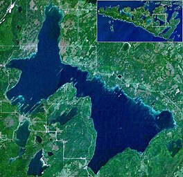 Satellite image of Lake Manitou on Manitoulin Island | |
 Lake Manitou | |
| Location | Manitoulin Island, Lake Huron |
| Coordinates | 45°46.7′N 81°59.5′W / 45.7783°N 81.9917°WCoordinates: 45°46.7′N 81°59.5′W / 45.7783°N 81.9917°W |
| Primary outflows | Manitou River |
| Basin countries | Canada |
| Max. length | 19.8 kilometres (12.3 mi) |
| Max. width | 6 kilometres (3.7 mi) |
| Surface area | 104 km² (40 sq mi) |
| Islands | 2 |

Lake Manitou is the largest lake on Manitoulin Island in Ontario, Canada. With an area of 104 square kilometres (40 sq mi),[1] it is the largest lake on a lake island in the world.[2][1][3] It is drained by the Manitou River.
There are a number of small islands in Lake Manitou, such as Roper Island and Bear Island in the very south of the western lobe of the lake, and McCracken's Island in the neck connecting the two lobes, making them islands in a lake on an island in a lake.[2] However, none of the islands are as large as Treasure Island in a neighboring, smaller lake on Manitou Island.

Manitoulin Island location in the Great Lakes

See also[]
- List of lakes in Ontario
References[]
- ^ a b "About The LMAA". Lake Manitou Area Association. Archived from the original on August 5, 2017. Retrieved October 12, 2011.
- ^ a b Roza, Greg (2009). The Creation of Islands. New York: Rosen Pub. pp. 25. ISBN 978-1-4358-5299-0. OCLC 254528993.
- ^ "Some interesting Islands and Lakes". Elbruz. Retrieved October 12, 2011.
External links[]
![]() Geographic data related to Lake Manitou at OpenStreetMap
Geographic data related to Lake Manitou at OpenStreetMap
This Northern Ontario geographical article is a stub. You can help Wikipedia by . |
- Lakes of Manitoulin Island
- Northern Ontario geography stubs