Lake Huron
| Lake Huron | |
|---|---|
 Lake Huron shorelines | |
 Lake Huron | |
 | |
| Location | North America |
| Group | Great Lakes |
| Coordinates | 44°48′N 82°24′W / 44.8°N 82.4°WCoordinates: 44°48′N 82°24′W / 44.8°N 82.4°W |
| Lake type | Glacial |
| Primary inflows | Straits of Mackinac, St. Marys River |
| Primary outflows | St. Clair River |
| Catchment area | 51,700 sq mi (134,100 km2)[8] |
| Basin countries | Canada and the United States |
| Max. length | 206 mi (332 km)[8] |
| Max. width | 183 mi (295 km)[8] |
| Surface area | 23,007 sq mi (59,588 km2)[8] |
| Average depth | 195 ft (59 m)[8] |
| Max. depth | 750 ft (229 m)[8] |
| Water volume | 850 cu mi (3,543 km3)[8] |
| Residence time | 22 years |
| Shore length1 | 1,850 mi (2,980 km) plus 1,980 mi (3,190 km) for islands[9] |
| Surface elevation | 577 ft (176 m)[8] |
| Islands | Manitoulin |
| Sections/sub-basins | Georgian Bay, North Channel |
| Settlements | Bay City, Alpena, Cheboygan, St. Ignace, Port Huron in Michigan; Goderich, Sarnia, Owen Sound in Ontario |
| References | [10] |
| 1 Shore length is not a well-defined measure. | |

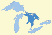
Lake Huron /ˈhjʊrɒn, ˈhjʊrən/ is one of the five Great Lakes of North America. Hydrologically, it comprises the easterly portion of Lake Michigan–Huron, having the same surface elevation as its westerly counterpart, to which it is connected by the 5-mile-wide (8.0 km), 20-fathom-deep (120 ft; 37 m) Straits of Mackinac. It is shared on the north and east by the Canadian province of Ontario and on the south and west by the U.S. state of Michigan. The name of the lake is derived from early French explorers who named it for the Huron people inhabiting the region. The Huronian glaciation was named from evidence collected from Lake Huron region. The northern parts of the lake include the North Channel and Georgian Bay. Saginaw Bay is located in the southwest corner of the lake. The main inlet is the St. Marys River, and the main outlet is the St. Clair River.
Geography[]
By surface area, Lake Huron is the second-largest of the Great Lakes, with a surface area of 23,007 square miles (59,590 km2) – of which 9,103 square miles (23,580 km2) lies in Michigan; and 13,904 square miles (36,010 km2) lies in Ontario – making it the third-largest fresh water lake on Earth (or the fourth-largest lake, if the Caspian Sea is counted as a lake).[8] By volume however, Lake Huron is only the third largest of the Great Lakes, being surpassed by Lake Michigan and Lake Superior.[11] When measured at the low water datum, the lake contains a volume of 850 cubic miles (3,500 km3) and a shoreline length (including islands) of 3,827 mi (6,159 km).[8]
The surface of Lake Huron is 577 feet (176 m) above sea level.[8] The lake's average depth is 32 fathoms 3 feet (195 ft (59 m)), while the maximum depth is 125 fathoms (750 ft (230 m)).[8] It has a length of 206 statute miles (332 km; 179 nmi) and a greatest breadth of 183 statute miles (295 km; 159 nmi).[8] A large bay that protrudes northeast from Lake Huron into Ontario, Canada, is called Georgian Bay. A notable feature of the lake is Manitoulin Island, which separates the North Channel and Georgian Bay from Lake Huron's main body of water. It is the world's largest lake island.[12] A smaller bay that protrudes southwest from Lake Huron into Michigan is called Saginaw Bay.
Cities with over 10,000 people on Lake Huron include Sarnia, the largest city on Lake Huron, and Saugeen Shores in Canada and Bay City, Port Huron, and Alpena in the United States. Major centres on Georgian Bay include Owen Sound, Wasaga Beach, Collingwood, Midland, Penetanguishene, Port Severn and Parry Sound.
Water levels[]
Historic high water The lake fluctuates from month to month with the highest lake levels in October and November. The normal high-water mark is 2.00 feet (0.61 m) above datum (577.5 ft or 176.0 m). In the summer of 1986, Lakes Michigan and Huron reached their highest level at 5.92 feet (1.80 m) above datum.[13] The high-water records were broken for several months in a row in 2020.[14]
Historic low water Lake levels tend to be the lowest in winter. The normal low-water mark is 1.00 foot (30 cm) below datum (577.5 ft or 176.0 m). In the winter of 1964, Lakes Michigan and Huron reached their lowest level at 1.38 feet (42 cm) below datum.[13] As with the high-water records, monthly low-water records were set each month from February 1964 through January 1965. During this twelve-month period, water levels ranged from 1.38 to 0.71 feet (42–22 cm) below Chart Datum.[13] The all-time low-water mark was eclipsed in January 2013.[15]
Geology[]

Lake Huron has the largest shore line length of any of the Great Lakes, counting its 30,000 islands.[16] It is separated from Lake Michigan, which lies at the same level, by the 5-mile-wide (8.0 km), 20-fathom-deep (120 ft; 37 m) Straits of Mackinac, making them hydrologically the same body of water (sometimes called Lake Michigan-Huron and sometimes described as two 'lobes of the same lake').[16] Aggregated, Lake Huron-Michigan, at 45,300 square miles (117,000 km2), "is technically the world's largest freshwater lake".[16] Lake Superior, at 21 feet higher elevation, drains into the St. Marys River which then flows into Lake Huron. The water then flows south to the St. Clair River, at Port Huron, Michigan and Sarnia, Ontario. The Great Lakes Waterway continues thence to Lake St. Clair; the Detroit River and Detroit, Michigan; into Lake Erie and thence – via Lake Ontario and the St. Lawrence River – to the Atlantic Ocean.
Like the other Great Lakes, it was formed by melting ice as the continental glaciers retreated toward the end of the last ice age. Before this, Lake Huron was a low-lying depression through which flowed the now-buried Laurentian and Huronian Rivers; the lake bed was criss-crossed by a large network of tributaries to these ancient waterways, with many of the old channels still evident on bathymetric maps.
The Alpena-Amberley Ridge is an ancient ridge beneath the surface of Lake Huron, running from Alpena, Michigan, southwest to Point Clark, Ontario.[17]
History[]

About 9,000 years ago, when water levels in Lake Huron were approximately 100 m (330 ft) below today's levels, the Alpena-Amberley Ridge was exposed. That land bridge was used as a migration route for large herds of caribou. Since 2008, archaeologists have discovered at least 60 stone constructions along the submerged ridge that are thought to have been used as hunting blinds by Paleo-Indians.[17] That a trade network brought obsidian from Oregon almost ten thousand years ago to be used for toolmaking was confirmed by a 2013 underwater discovery along the ridge.[18]
On the eve of European contact, the extent of development among Eastern Woodlands Native American societies is indicated by the archaeological evidence of a town on or near Lake Huron that contained more than one hundred large structures housing a total population of between 4,000 and 6,000.[19] The French, the first European visitors to the region, often referred to Lake Huron as La Mer Douce, "the fresh-water sea". In 1656, a map by French cartographer Nicolas Sanson refers to the lake by the name Karegnondi, a Wyandot word that has been translated variously, as "Freshwater Sea", "Lake of the Hurons", or simply "lake".[20][21] Generally, the lake was labeled "Lac des Hurons" (Lake of the Huron) on most early European maps.[21]
By the 1860s, many European settlements on the shores of Lake Huron were becoming incorporated, including Sarnia, the largest city on Lake Huron.[22] On October 26, 2010,[23] the Karegnondi Water Authority was formed to build and manage a pipeline from the lake to Flint, Michigan.[24]
Shipwrecks[]
More than a thousand wrecks have been recorded in Lake Huron. Of these, 185 are located in Saginaw Bay, and 116 are found in the 448-square-mile (1,160 km2) Thunder Bay National Marine Sanctuary and Underwater Preserve, which was established in 2000. Georgian Bay contains 212 sunken vessels.[25]
Purportedly the first European vessel to sail the Great Lakes, Le Griffon, also became the first ship lost on the Great Lakes. Built in 1679 on the eastern shore of Lake Erie near Buffalo, New York. Robert Cavalier, Sieur de la Salle navigated across Lake Erie, up the Detroit River, Lake St. Clair and the St. Clair River out into Lake Huron. Passing the Straits of Mackinac, La Salle made landfall on Washington Island, off the tip of the Door Peninsula on the Wisconsin side of Lake Michigan. La Salle filled Le Griffon with pelts and in late November 1679 sent Le Griffon back to the site of modern-day Buffalo, never to be seen again. Two wrecks have been identified as Le Griffon, although neither has gained final verification as the actual wreck. Blown by a fierce storm after leaving, Le Griffon ran aground before the storm. The people of Manitoulin Island say that the wreck in Mississagi Strait at the western tip of the island is that of Le Griffon.[26][27][28] Meanwhile, others near Tobermory, say that the wreck on , 150 miles (240 km) farther east in Georgian Bay, is that of Le Griffon.[27][29]
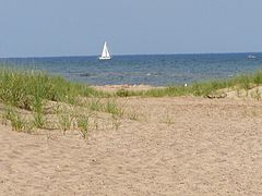
View of Lake Huron from East Tawas State Park at the head of Saginaw Bay

Harrisville Beach on Lake Huron

View of rocky shore of Lake Huron from east of Port Dolomite, Michigan, in the upper peninsula


Storm of 1913[]
On November 9, 1913, the Great Lakes Storm of 1913 in Lake Huron sank 10 ships, and more than 20 were driven ashore. The storm, which raged for 16 hours, killed 235 seamen.[30]
Matoa—a propeller freighter weighing 2,311 gross register tons—had passed between Port Huron, Michigan, and Sarnia, Ontario, just after midnight. On November 9, just after six in the morning, Senator pushed upstream. Less than an hour later, Manola—a propeller freighter of 2,325 gross register tons also built in Cleveland in 1890— passed through. Captain Frederick W. Light of Manola reported that both the Canadian and the American weather stations had storm flag signals flying from their weather towers.[31] Following behind at 7:00 a.m. that Sunday, Regina steamed out of Sarnia into the northwest gale. The warnings had been up for four hours.[32] Manola passed Regina off Port Sanilac, 22 statute miles (19 nmi; 35 km) up the lake. Captain Light determined that if it continued to deteriorate, he would seek shelter at Harbor Beach, Michigan, another 30 statute miles (26 nmi; 48 km) up the lake. There, he could seek shelter behind the breakwater. Before he reached Harbor Beach, the winds turned to the northeast and the lake began to rise. It was noon when he reached Harbor Beach and ran for shelter.
The waves were so violent that Manola touched bottom entering the harbor. With help from a tugboat, Manola tied up to the break wall with eight lines. It was about 3:00 p.m. when Manola was secured and the crew prepared to drop anchor. As they worked, the cables began to snap from wind pressure against the hull. To keep from being pushed aground, they kept their bow into the wind with the engines running half to full in turns, yet the ship still drifted 800 feet (240 m) before its movement was arrested.[33] Waves breaking over the ship damaged several windows, and the crew reported seeing portions of the concrete break wall peeling off as the waves struck it.[34] Meanwhile, fifty miles farther up the lake, Matoa and Captain Hugh McLeod had to ride out the storm without a safe harbor.[35] Matoa was found stranded on the Port Austin reef when the winds subsided.[36]
It was noon on Monday before the winds let up and not until 11:00 p.m. that night before Captain Light determined it to be safe to continue his journey.[37] Although Manola survived the storm, she was renamed Mapledawn in 1920, and on November 24, 1924, she became stranded on Christian Island[38] in Georgian Bay. It was declared a total loss. Salvagers were able to recover approximately 75,000 bushels of barley.[39]
Ecology[]

Lake Huron has a lake retention time of 22 years. Like all of the Great Lakes, the ecology of Lake Huron has undergone drastic changes in the last century. The lake originally supported a native deepwater fish community dominated by lake trout, which fed on several species of ciscos as well as sculpins and other native fishes. Several invasive species, including sea lamprey, alewife and rainbow smelt, became abundant in the lake by the 1930s. The major native top predator, lake trout, was virtually extirpated from the lake by 1950 through a combination of overfishing and the effects of sea lamprey. Several species of ciscos were also extirpated from the lake by the 1960s; the only remaining native cisco is the bloater. Non-native Pacific salmon have been stocked in the lake since the 1960s, and lake trout have also been stocked in an attempt to rehabilitate the species, although little natural reproduction of stocked trout has been observed.
Lake Huron has suffered recently by the introduction of a variety of new invasive species, including zebra and quagga mussels, the spiny water flea, and round gobies. The demersal fish community of the lake was in a state of collapse by 2006,[40] and a number of drastic changes have been observed in the zooplankton community of the lake.[41] Chinook salmon catches have also been greatly reduced in recent years, and lake whitefish have become less abundant and are in poor condition. These recent changes may be attributable to the new exotic species.
See also[]
- Drummond Island
- Hurricane Huron
- Les Cheneaux Islands
- Mackinac Island
- Manitoulin Island
- Michigan lighthouses
- Shipwrecks of the 1913 Great Lakes storm and List of victims of the 1913 Great Lakes storm
Great Lakes in general[]
- Great Lakes Areas of Concern
- Great Lakes census statistical areas
- Great Lakes Commission
- Great Recycling and Northern Development Canal
- International Boundary Waters Treaty
- List of cities along the Great Lakes
- Seiche
- Sixty Years' War for control of the Great Lakes
- Third Coast
- Snowbelt
Notes[]
- ^ National Geophysical Data Center, 1999. Bathymetry of Lake Erie and Lake Saint Clair. National Geophysical Data Center, NOAA. doi:10.7289/V5KS6PHK [access date: 2015-03-23]. (only small portion of this map)
- ^ National Geophysical Data Center, 1999. Bathymetry of Lake Huron. National Geophysical Data Center, NOAA. doi:10.7289/V5G15XS5 [access date: 2015-03-23].
- ^ National Geophysical Data Center, 1996. Bathymetry of Lake Michigan. National Geophysical Data Center, NOAA. doi:10.7289/V5B85627 [access date: 2015-03-23]. (only small portion of this map)
- ^ National Geophysical Data Center, 1999. Bathymetry of Lake Ontario. National Geophysical Data Center, NOAA. doi:10.7289/V56H4FBH [access date: 2015-03-23]. (only small portion of this map)
- ^ National Geophysical Data Center, 1999. Bathymetry of Lake Superior. National Geophysical Data Center, NOAA. [access date: 2015-03-23].
(the general reference to NGDC because this lake was never published, compilation of Great Lakes Bathymetry at NGDC has been suspended). (only small portion of this map) - ^ National Geophysical Data Center, 1999. Global Land One-kilometer Base Elevation (GLOBE) v.1. Hastings, D. and P.K. Dunbar. National Geophysical Data Center, NOAA. doi:10.7289/V52R3PMS [access date: 2015-03-16].
- ^ "About Our Great Lakes: Tour". National Oceanic and Atmospheric Administration (NOAA) - Great Lakes Environmental Research Laboratory (GLERL). Archived from the original on 5 May 2011. Retrieved 2 April 2015. Google Earth Great Lakes Tour GreatLakesTour_Merged.kmz Archived 2015-01-05 at the Wayback Machine
- ^ Jump up to: a b c d e f g h i j k l m "Great Lakes Factsheet No. 1". U.S. Environmental Protection Agency. June 25, 2012. Retrieved March 6, 2014.
- ^ Shorelines of the Great Lakes Archived 2015-04-05 at the Wayback Machine
- ^ Wright, John W., ed. (2006). The New York Times Almanac (2007 ed.). New York, New York: Penguin Books. p. 64. ISBN 0-14-303820-6.
- ^ Annin, Peter (2006). The Great Lakes Water Wars. Island Press. p. 15. ISBN 978-1-55963-087-0.
- ^ "Seven Wonders of Canada-Manitoulin Island, Ontario". CBC.ca. Retrieved 8 October 2016.
- ^ Jump up to: a b c Monthly bulletin of Lake Levels for The Great Lakes; September 2009; U.S. Army Corps of Engineers, Detroit District
- ^ "Great Lakes Water Level Data". 3 February 2021. Retrieved 9 February 2021.
- ^ "Great Lakes Water Level Data". 3 February 2021. Retrieved 9 February 2021.
- ^ Jump up to: a b c "Great Lakes Map". Michigan Department of Natural Resources and Environment. Retrieved February 19, 2011.
- ^ Jump up to: a b Weber, Bob (29 April 2014). "Prehistoric Stone Walls Found Under Lake Huron". CTV News. The Canadian Press. Retrieved 8 October 2016.
- ^ Aaron, Martin (June 1, 2021). "At the Bottom of Lake Huron, an Ancient Mystery Materializes". Scientific American. Springer Nature America. Retrieved June 3, 2021.
- ^ Nash, Gary B. Red, White and Black: The Peoples of Early North America Los Angeles 2015. Chapter 1, p. 8
- ^ Sioui, Georges E. (1999). Huron-Wendat: The Heritage of the Circle. Translated by Brierley, Jane. UBC Press. ISBN 9780774807159.
- ^ Jump up to: a b Fonger, Ron (May 3, 2007). "Genesee, Oakland counties adopt historic name for water group". The Flint Journal. Retrieved 6 December 2011.
- ^ "Lake Huron at the time of Confederation". University of Toronto Archives: Showcase 150. Retrieved 28 Jan 2020.
- ^ Thorne, Blake (October 27, 2010). "Karegnondi Water Authority sets course for cutting ties with Detroit water". Flint Journal. Retrieved 6 December 2011.
- ^ Fonger, Ron (October 23, 2010). "Years in the making, Karegnondi Water Authority is ready to set new course for water". Flint Journal. Retrieved 6 December 2011.
- ^ Shipwrecks of Lake Huron . . . The Great Sweetwater Sea, Jack Parker, Avery Color Studios, Au Train, Michigan, 1986, pp. 65-77
- ^ Allen, Durward L. (September 1959). "Lasalle's Griffin?". Boys' Life. Boy Scouts of America. pp. 19, 76–77.
- ^ Jump up to: a b "Mississagi Lighthouse". Archived from the original on 2013-07-12. Retrieved 2013-07-01.CS1 maint: bot: original URL status unknown (link)
- ^ The Griffon - First Ghost Ship on the Great Lakes Archived 2009-06-23 at the Wayback Machine. Michigansotherside.com. Retrieved on 2013-07-12.
- ^ Shipwrecks of Lake Huron . . . The Great Sweetwater Sea, Jack Parker, Avery Color Studios, Au Train, Michigan, 1986, pp. 25-26
- ^ True Tales of the Great Lakes, by Dwight Boyer; p. 212
- ^ True Tales of the Great Lakes, by Dwight Boyer; p. 266
- ^ True Tales of the Great Lakes, by Dwight Boyer; p. 268
- ^ Freshwater Fury by Frank Barcus, p. 72
- ^ True Tales of the Great Lakes, by Dwight Boyer, p. 269
- ^ True Tales of the Great Lakes, by Dwight Boyer, pp. 272-73
- ^ Shipwrecks of Lake Huron . . . The Great Sweetwater Sea, Jack Parker, Avery Color Studios, Au Train, Michigan, 1986, p. 56
- ^ Freshwater Fury by Frank Barcus, p. 73
- ^ Shipwrecks of Lake Huron . . . The Great Sweetwater Sea, Jack Parker, Avery Color Studios, Au Train, Michigan, 1986, p. 71
- ^ Great Lakes Vessels Index; Historical Collections of the Great Lakes; Bowling Green State University, Bowling Green, Ohio
- ^ Riley, S. C. et al. 2008. "Deepwater demersal fish community collapse in Lake Huron". Transactions of the American Fisheries Society 137: 1879-1880.
- ^ Barbiero, R. P. et al. 2009. "Recent shifts in the crustacean zooplankton community of Lake Huron". Canadian Journal of Fisheries and Aquatic Sciences 66: 816-828.
External links[]
 Media related to Lake Huron at Wikimedia Commons
 Geographic data related to Lake Huron at OpenStreetMap
- NOAA chart #14860 (Lake Huron)
- EPA's Great Lakes Atlas
- Fish Species of Lake Huron
- Great Lakes Coast Watch
- Lake Huron Binational Partnership Action Plan
- Lake Huron Data
- Lake Huron GIS
- Michigan DNR map of Lake Huron
- Bathymetry of Lake Huron
- In the Depths of Lake Huron, Secrets of an Ancient Sea
- U.S. Geological Survey Geographic Names Information System: Lake Huron
Lighthouses[]
- Interactive map of lighthouses, Georgian Bay, Lake Huron
- Interactive map of lighthouses in North and East Lake Huron
- Interactive map of lighthouses in North and West Lake Huron
| show Great Lakes of North America |
|---|

| show Central/Mid-Michigan including the Tri-Cities and Thumb |
|---|
| show Upper Peninsula of Michigan |
|---|
| show Authority control |
|---|
- Lake Huron
- Lakes of Ontario
- Great Lakes Waterway
- Lakes of Michigan
- Canada–United States border
- International lakes of North America
- Great Lakes