Lake Eyre
| Kati Thanda–Lake Eyre | |
|---|---|
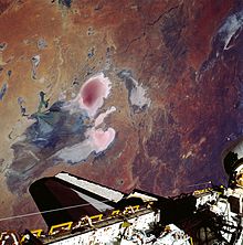
 Composite Landsat 7 satellite image in 1999 using shortwave infrared, near-infrared, and blue wavelengths | |
 Kati Thanda–Lake Eyre | |
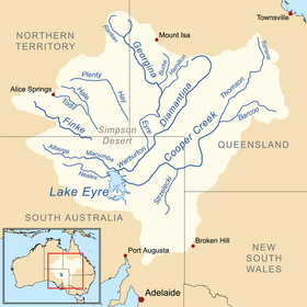 A map of the Lake Eyre basin, with the lake at bottom left | |
| Location | Northern South Australia |
| Coordinates | 28°22′S 137°22′E / 28.367°S 137.367°ECoordinates: 28°22′S 137°22′E / 28.367°S 137.367°E |
| Lake type | Ancient lake, Endorheic |
| Primary inflows | Warburton River |
| Primary outflows | Evaporation |
| Basin countries | Australia |
| Surface area | 9,500 km2 (3,668 sq mi) (max) |
| Average depth | 1.5 m (5 ft) (every 3 years), 4 m (13 ft) (every decade) |
| Surface elevation | −9 m (−30 ft) (shoreline when full); −15 m (−49 ft) (lowest point when empty) |

Lake Eyre (/ɛər/ AIR), officially known as Kati Thanda–Lake Eyre,[1] is an endorheic lake in east-central Far North South Australia, some 700 km (435 mi) north of Adelaide. The shallow lake is the depocentre of the vast endorheic Lake Eyre basin, and contains the lowest natural point in Australia at approximately 15 m (49 ft) below sea level (AHD), and on the rare occasions that it fills completely, is the largest lake in Australia covering an area up to 9,500 km2 (3,668 sq mi). When the lake is full, it has the same salinity level as seawater, but becomes hypersaline as the lake dries up and the water evaporates.
The lake was named in honour of Edward John Eyre, the first European to see it in 1840. The lake's official name was changed in December 2012 to combine the name "Lake Eyre" with the Aboriginal name, Kati Thanda.[1] The native title over the lake and surrounding region is held by the Arabana people.[2]
Geography[]


Kati Thanda–Lake Eyre is in the deserts of central Australia, in northern South Australia. The Lake Eyre Basin is a large endorheic system surrounding the lakebed, the lowest part of which is filled with the characteristic salt pan caused by the seasonal expansion and subsequent evaporation of the trapped waters. Even in the dry season, there is usually some water remaining in Kati Thanda–Lake Eyre, normally collecting in over 200 smaller sub-lakes within its margins. The lake was formed by aeolian processes after tectonic upwarping occurred to the south subsequent to the end of the Pleistocene epoch.[3]
During the rainy season, rivers from the north-east part of the Lake Eyre Basin—in outback (south-west and central) Queensland—flow towards the lake through the Channel Country. The amount of water from the monsoon determines whether water will reach the lake and, if it does, how deep the lake will get. The average rainfall in the area of the lake is 100 to 150 millimetres (3.9 to 5.9 in) per year.[3]
The −15 m (−49 ft) altitude usually attributed to Kati Thanda–Lake Eyre refers to the deepest parts of the lake floor, in Belt Bay and the Madigan Gulf. The shoreline lies at −9 m (−30 ft).[4] The lake is the area of maximum deposition of sediment in the Lake Eyre Basin.[5]
Lake Eyre is divided into two sections which are joined by the Goyder Channel. These are known as Lake Eyre North, which is 144 kilometres (89 mi) in length and 65 kilometres (40 mi) wide, and Lake Eyre South, which measures 65 by 24 kilometres (40 by 15 mi).[6] The salt crusts are thickest—up to 50 cm (20 in)—in the southern Belt Bay, Jackboot Bay and Madigan Gulf sub-basins of Lake Eyre North.[7]
Since 1883, proposals have been made to flood Lake Eyre with seawater brought to the basin via a canal or pipeline. The purpose was, in part, to increase evaporation and thereby increase rainfall in the region downwind of an enlarged Lake Eyre.[8] The added rainfall has been modeled as small.[9] Due to the basin's low elevation below sea level and the region's high annual evaporation rate (between 2,500 and 3,500 millimetres (98 and 138 in)[10]), such schemes have generally been considered impractical, as it is likely that accumulation of salt deposits would rapidly block the engineered channel.[11] At a rate of 1 cm (0.39 in) evaporation per day, a 3 m (9.8 ft) viaduct flowing a 0.5 m/s (1.6 ft/s) would supply enough water to create a 100 km2 (39 sq mi) sea. If brine water was not sent back to the ocean, it would precipitate 90,000 long tons (91,000 t) of salt every year.[citation needed]
Salinity[]
The salinity in the lake increases as the 450 mm (18 in) salt crust dissolves over a period of six months of a major flood, resulting in a massive fish kill. When over 4 m (13 ft) deep, the lake is no more salty than the sea, but salinity increases as the water evaporates, with saturation occurring at about a 500 mm (20 in) depth. The lake takes on a pink hue when saturated, due to the presence of beta-carotene pigment caused by the alga Dunaliella salina.
History[]
Wangkangurru (also known as Arabana/Wangkangurru, Wangganguru, Wanggangurru, Wongkangurru) is an Australian Aboriginal language spoken on Wangkangurru country. It is closely related to Arabana language of South Australia. The Wangkangurru language region was traditionally in the South Australian-Queensland border region taking in Birdsville and extending south towards Innamincka and Lake Eyre, including the local government areas of the Shire of Diamantina as well as the Outback Communities Authority of South Australia.[12]
Floods[]

Typically a 1.5 m (5 ft) flood occurs every three years, a 4 m (13 ft) flood every decade, and a fill or near fill a few times a century. The water in the lake soon evaporates, with a minor or medium flood drying by the end of the following summer. Most of the water entering the lakes arrives via Warburton River.[3]
In strong La Niña years, the lake can fill. Since 1885, this has occurred in 1886–1887, 1889–1890, 1916–1917, 1950, 1955, 1974–1977,[13] and 1999–2001,[14] with the highest flood of 6 m (20 ft) in 1974. Local rain can also fill Kati Thanda–Lake Eyre to 3–4 m (9.8–13.1 ft), as occurred in 1984 and 1989. Torrential rain in January 2007 took about six weeks to reach the lake but only placed a small amount of water into it.[15]
When recently flooded, the lake is almost fresh, and native freshwater fish, including bony bream (Nematolosa erebi), the Lake Eyre Basin sub-species of golden perch (Macquaria ambigua) and various small hardyhead species (Craterocephalus spp.) can survive in it.
2009 to 2011[]
The 2009 Lake Eyre flood peaked at 1.5 m (5 ft) deep in late May, which is a quarter of its maximum recorded depth of 6 m (20 ft). 9 km3 (2 cu mi) of water crossed the Queensland–South Australian border with most of it coming from massive floods in the Georgina River. However, owing to the very low rainfall in the lower reaches of these rivers (contrasting with heavy rainfall in the upper catchments),[16] the greater proportion soaked into the desert or evaporated en route to the lake, leaving less than 4 km3 (0.96 cu mi) in the lake, which covered an area of 800 km2 (309 sq mi), or 12% of the total. As the flood did not start filling the lake's deepest point (Belt Bay) until late March, little bird life appeared, preferring instead to nest in the upper reaches of the Lake Eyre Basin, north of Birdsville, where large lakes appeared in January as a result of monsoonal rain.[citation needed]
The high rainfall in summer 2010 sent flood water into the Diamantina, Georgina and Cooper Creek catchments of the Lake Eyre basin, with the Cooper Creek reaching the lake for the first time since 1990. The higher rainfall prompted many different birds to migrate back to the area for breeding.[17]
Heavy local rain in early March 2011 in the Stuart Creek and Warriner catchments filled Lake Eyre South, with Lake Eyre North about 75 per cent covered with water firstly from the Neales and Macumba Rivers, and later from the Warburton River.[18]
2015 to 2016[]
In late 2015, water began flowing into Lake Eyre following heavy rain in the north-east of the state.[19]
2019[]
In late March 2019, floodwaters began arriving as a result of torrential rains in northern Queensland in January. In the past, the water had taken anywhere from three to 10 months to reach the lake, but this time it arrived in two. The first flooding would be closely followed by another surge, following rains produced by Cyclone Trevor. Traditional owners and graziers agree that it is essential that the river run its course and should not be harvested during floods, as any interference in the natural systems could damage the ecosystem.[20]
Yacht club[]
The Lake Eyre Yacht Club is a dedicated group of sailors who sail on the lake's floods, including recent trips in 1997, 2000, 2001, 2004, 2007 and 2009.[21] A number of 6 m (20 ft) trailer sailers sailed on Kati Thanda–Lake Eyre in 1975, 1976, and 1984, when the flood depth reached 3–6 m (9.8–19.7 ft). In July 2010 The Yacht Club held its first regatta since 1976[22] and its first on Lake Killamperpunna, a freshwater lake on Cooper Creek. The Cooper had reached Kati Thanda–Lake Eyre for the first time since 1990.[23] It is estimated that these waters reach Lake Eyre roughly 8 years in 100. [24]
When the lake is full, a notable phenomenon is that around midday the surface can often become very flat. The surface then reflects the sky in a way that leaves both the horizon and water surface virtually impossible to see. The commodore of the Lake Eyre Yacht Club has stated that sailing during this time has the appearance of sailing in the sky.[25]
Land speed record attempts[]
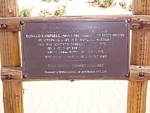
Kati Thanda–Lake Eyre has been a site for various land speed record attempts on its salt flats, similar to those found in the Bonneville Salt Flats, especially those by Donald Campbell with the Bluebird-Proteus CN7.[26]
Biota[]
Phytoplankton in the lake includes Nodularia spumigena and a number of species of Dunaliella.[3]
Birds[]
Birds such as pelicans and banded stilts are drawn to a filled lake from southern coastal regions of Australia, and from as far afield as Papua New Guinea. During the 1989���1990 flood, it was estimated that 200,000 pelicans, 80% of Australia's total population, came to feed & roost at Lake Eyre.[27] Scientists are presently unable to determine how such birds appear able to detect the filling of the lake, even when hundreds or thousands of kilometres away from the basin.[28]
Protected area status[]
Statutory[]
The extent of the lake is covered by two protected areas declared by the Government of South Australia - the Kati Thanda-Lake Eyre National Park and the Elliot Price Conservation Park.[29]
Non-statutory[]
Wetlands[]
Lake Eyre is on the list of wetlands of national importance known as A Directory of Important Wetlands in Australia.[30]
Important bird area[]
Lake Eyre has been identified by BirdLife International as an Important Bird Area (IBA) known as the Lake Eyre Important Bird Area, because, when flooded, it supports major breeding events of the Banded stilt and Australian pelican, as well as over 1% of the world populations of Red-necked avocets, Sharp-tailed sandpipers, Red-necked stints, Silver gulls and Caspian terns.[31]
See also[]
References[]
- ^ Jump up to: a b "New name adopted for outback Lake Eyre". Australian Broadcasting Corporation. 19 December 2012.
- ^ "Federal Court awards native title over Lake Eyre". ABC News. Australia. 23 May 2012.
- ^ Jump up to: a b c d O'Sullivan, Patrick; C. S. Reynolds (2008). The Lakes Handbook: Lake Restoration and Rehabilitation, Volume 2. John Wiley & Sons. pp. 233–235. ISBN 1405141107.
- ^ Lake Eyre Archived 23 May 2012 at the Wayback Machine. International Lake Environment Committee. Retrieved 29 March 2012.
- ^ Laity, Julie J. (2009). Deserts and Desert Environments. John Wiley & Sons. p. 112. ISBN 1444300741.
- ^ Rafferty, John P. (2007). Lakes and Wetland. The Rosen Publishing Group. p. 186. ISBN 1615303200.
- ^ Dulhunty, J.A. (1990): Lake Eyre, In: M.J. Tyler, C.R. Twidale, M. Davis and C.B. Walker, Natural History of the North East Deserts. Royal Society of South Australia Inc. Pp. 101-4. ISBN 0-9596627-5-8
- ^ Badescu, V., Cathcart, R.B., Bolonkin, A.A., Paulescu, M. and Gravila, P. (2013) Macro-engineering Australia's Lake Eyre with imported seawater. International Journal of Environment and Sustainable Development 12: 264-284.
- ^ Hope, Pandora & Nicholls, Neville & L. McGregor, John. (2004). "The rainfall response to permanent inland water in Australia" Aust. Meteorol. Mag.
- ^ Badman, F.J. (1991): Introduction. In: F.J. Badman, B.K. Arnold and S.L. Belt, A Natural History of the Lake Eyre Region. The South Australian National Parks and Wildlife Service's Northern Consultative Committee. P 1. ISBN 0 646 07183 1
- ^ The Plan To Fill Lake Eyre TROVE: The Sydney Morning Herald, 27 May 1954. Retrieved 8 February 2016.
- ^
 This Wikipedia article incorporates CC-BY-4.0 licensed text from: "Wangkangurru". Queensland Aboriginal and Torres Strait Islander languages map. State Library of Queensland. Retrieved 23 January 2020.
- ^ Allen, Robert J.; The Australasian Summer Monsoon, Teleconnections, and Flooding in the Lake Eyre Basin; published 1985 by Royal Geographical Society of Australasia, S.A. Branch; ISBN 0-909112-09-6
- ^ Australian Bureau of Meteorology; Annual Climate Summary (2000)
- ^ "Lake Eyre flooding attracts yachting club interest". ABC News. Australia. 8 March 2007.
- ^ Australian Annual Climate Summary 2009
- ^ Lake Eyre floods again Archived 15 May 2013 at the Wayback Machine, Australian Geographic, 15 July 2010
- ^ "Flooding and storms fill outback lake". ABC News. Australia. 9 March 2011. Retrieved 29 March 2012.
- ^ "Lake Eyre begins filling with water after soaking rains". ABC News. Retrieved 4 January 2016.
- ^ Schwartz, Dominique (9 May 2019). "Wild Abandon". 7:30. Photography by Brendan Esposito. Australian Broadcasting Corporation News.
- ^ Welcome to the Lake Eyre Yacht Club. Retrieved 29 March 2012.
- ^ "Lake Eyre - 9,690 km2 - Facts, Map, Activities". lakepedia.com. Retrieved 30 September 2017.
- ^ "Lake Eyre Facts | Travel Outback Australia". Retrieved 8 March 2021.
- ^ Kingsford, R. T; Curtin, A. L; Porter, J (1 May 1999). "Water flows on Cooper Creek in arid Australia determine 'boom' and 'bust' periods for waterbirds". Biological Conservation. 88 (2): 231–248. doi:10.1016/S0006-3207(98)00098-6. ISSN 0006-3207.
- ^ Tinson, Sam (May 2011). "Dry country". Sails Magazine (7). Archived from the original on 31 March 2017. Retrieved 30 March 2017.
Often you get becalmed in the middle of the lake at midday, and the surface is like a mirror, the water and the sky become one. You get a light sea fog and it’s almost like you’re floating in a cloud. It’s a very beautiful thing.
- ^ John Pearson (author). Bluebird and the Dead Lake.
- ^ TCR, White (2005). Why Does the World Stay Green?: Nutrition and Survival of Plant-eaters. Csiro Publishing. p. 88. ISBN 0643099816.
- ^ Birds set to return to Lake Eyre to breed as inland lakes fill with water ABC News, 6 January 2016.
- ^ "Kati Thanda-Lake Eyre National Park Map" (PDF). Department of Environment, Water and Natural Resources. Retrieved 5 February 2015.
- ^ Eyles, Kathy (2001). A Directory of important wetlands in Australia (PDF) (3 ed.). Environment Australia. p. 78. ISBN 978-0-642-54721-7.
- ^ "Important Bird Areas factsheet: Lake Eyre". Birdata. Birdlife International. Retrieved 5 February 2015.
Further reading[]
| Wikimedia Commons has media related to Lake Eyre. |
- Schwarz, Dominique (10 May 2019). "The re-birth of Lake Eyre" (video). ABC News. 7:30 Report. Australian Broadcasting Corporation.
- Dr Vincent Kotwicki: Floods of Lake Eyre - interesting site with much data, including Lake Eyre inflows 1885–2012.
- Salt - documentary film by Murray Fredericks and Michael Angus (synopsis)
- NASA Earth Observatory: Lake Eyre Filling Peaks - 21 June 2009
- Lake Eyre Yacht Club website
External links[]
| show Authority control |
|---|
- Ancient lakes
- Saline lakes of South Australia
- Endorheic lakes of Australia
- Lake Eyre basin
- Far North (South Australia)
- Extreme points of Australia
- Lowest points