Cape (geography)

Cape Cod and the islands off the Massachusetts coast, from space

Cape Tisan in Mersin Province, Turkey

Cape Tindari and Marinello lagoons, Sicily
In geography, a cape is a headland or a promontory of large size extending into a body of water, usually the sea.[1] A cape usually represents a marked change in trend of the coastline which makes them prone to natural forms of erosion, mainly tidal actions. This results in capes having a relatively short geological lifespan. Capes can be formed by glaciers, volcanoes, and changes in sea level. Erosion plays a large role in each of these methods of formation.[citation needed]
List of some well-known capes[]
| Country | Cape | Significance |
|---|---|---|
| Albania | Cape of Gjuhëz, Karaburun Peninsula | |
| Cape of Rodon | ||
| Antarctica | Cape Shirreff | The land in the Antarctic Treaty area closest to a non-Antarctic territory |
| Cape Dubouzet | Northeasternmost point of the Antarctic Peninsula | |
| Argentina | Cape Virgenes | |
| Australia | Cape Byron | |
| Cape Leeuwin | ||
| Cape York | ||
| Brazil | Cape São Roque | |
| Ponta do Seixas (Cape Branco) | ||
| Bulgaria | Cape Emine | |
| Cape Kaliakra | ||
| Canada | Cape Breton Island, Nova Scotia | |
| Cape Chidley, Newfoundland and Labrador / Nunavut | ||
| Cape Columbia, Nunavut | Northernmost point in Canada 83°6′41″N 69°57′30″W / 83.11139°N 69.95833°W | |
| Cap Diamant, Quebec City | ||
| Cape Race, Newfoundland and Labrador | ||
| Cape Spear, Newfoundland and Labrador | Easternmost point in Canada 47°31′25″N 52°37′10″W / 47.52361°N 52.61944°W | |
| Murchison Promontory, Nunavut | Northern tip of mainland North America 72°00′00″N 94°38′59″W / 72.00000°N 94.64972°W | |
| Chile | Cape Froward | |
| Cape Horn | Northern boundary of the Drake Passage Meetingplace of the Atlantic and Pacific Oceans | |
| Cyprus | Cape Greco | |
| Djibouti and Eritrea | Ras Doumeira | Northernmost point in Djibouti Southern point in Eritrea |
| Eritrea and Sudan | Ras Kasar | Northernmost point in Eritrea Easternmost point in Sudan |
| France | Cap Gris Nez | Closest point of France to England |
| Germany | Cape Arkona | |
| Ghana | Cape Coast | |
| Greece | Cape Matapan (Cape Tainaron), on Peloponnesus) | Southern tip of mainland Europe 36°23′06″N 22°28′58″E / 36.38500°N 22.48278°E |
| Greenland | Cape Discord | |
| Cape Farewell | Southernmost point of Greenland 59°46′23″N 43°55′21″W / 59.77306°N 43.92250°W | |
| Cape Morris Jesup | Northernmost point of mainland Greenland 83°37′39″N 32°39′52″W / 83.62750°N 32.66444°W | |
| India | Cape Comorin | Southernmost point of Mainland India, at the trijunction of Arabian Sea, Bay of Bengal and, Indian Ocean. |
| Cabo de Rama | ||
| Diu Head | ||
| False Divi Point | ||
| False Point | ||
| Headland Sada (Goa) | ||
| Indira Point | Southernmost point of India, at the trijunction of Andaman Sea, Bay of Bengal and, the Strait of Malacca. | |
| Palmyras Point | ||
| Point Calimere | ||
| Latvia | Cape Kolka | |
| Liberia | Cape Mesurado | Location of Monrovia |
| Cape Palmas | Southernmost point in Liberia 4°22′34″N 7°43′01″W / 4.37611°N 7.71694°W | |
| Grand Cape Mount | ||
| Mauritania | Cape Blanc | |
| Malawi | Cape Maclear | |
| Mexico | Cabo San Lucas, Baja California Sur | |
| Morocco | Cape Juby | |
| Cape Three Forks | ||
| Myanmar | Cape Negrais | Known as Pagoda Point or Mawtin Point (Mawtin Zoon). It is located 133 km to the NNE of Preparis Island and 193 km from the nearest point in the Indian union territory of the Andaman and Nicobar Islands. |
| New Zealand | Cape Egmont | |
| Cape Foulwind | ||
| Cape Kidnappers | ||
| Cape Reinga | ||
| East Cape | ||
| North Cape | ||
| Norway | Cape Nordkinn | Northern tip of mainland Europe 71°08′02″N 27°39′00″E / 71.13389°N 27.65000°E |
| North Cape | ||
| Pakistan | Ras Muari | |
| Poland | Cape Rozewie | |
| Cape Rzucewo | ||
| Portugal | Cabo da Roca | Western tip of mainland Europe 38°46′5″N 9°30′2″W / 38.76806°N 9.50056°W |
| Cape St. Vincent / Sagres Point | Southwestern tip of mainland Europe 37°1′30″N 8°59′40″W / 37.02500°N 8.99444°W | |
| Philippines | Cape Engaño | |
| Russia | Cape Chelyuskin | Northern tip of mainland Asia 77°44′0″N 104°15′0″E / 77.73333°N 104.25000°E |
| Cape Dezhnev | Easternmost point in mainland Asia 66°4′45″N 169��39′7″W / 66.07917°N 169.65194°W | |
| Cape Idokopas | Location of the Putin's Palace | |
| Senegal | Cap-Vert | Westernmost point in mainland Africa 14°44′41″N 17°31′13″W / 14.74472°N 17.52028°W Location of Dakar (capital of Senegal) |
| Somalia | Cape Guardafui | Second easternmost point in mainland Africa 11°49′N 51°15′E / 11.817°N 51.250°E |
| South Africa | Cape Agulhas | Southernmost point in mainland Africa 34°51′15″S 17°33′22″E / 34.85417°S 17.55611°E Beginning of dividing line between the Atlantic and Indian Oceans |
| Cape of Good Hope | ||
| South Korea | Seopjikoji | |
| Spain | Cape Finisterre | |
| Cape Trafalgar | ||
| Tunisia | Cap Bon | |
| Ras ben Sakka | Northernmost point in mainland Africa 37°21′00″N 9°45′00″E / 37.350°N 9.750°E | |
| Boto | ||
| Turkey | Cape Baba | Western tip of mainland Asia 39°28′46.88″N 26°3′50.29″E / 39.4796889°N 26.0639694°E |
| Sarayburnu, İstanbul | Easternmost point of Istanbul Separates the Golden Horn Bay from the Sea of Marmara 41°01′01″N 28°59′11″E / 41.0169°N 28.9864°E | |
| United Kingdom | Cape Cornwall, Cornwall | |
| Cape Wrath, Scotland | ||
| United States | Cape Ann, Massachusetts | |
| Cape Canaveral, Florida | Location of Kennedy Space Center | |
| Cape Charles, Virginia | ||
| Cape Cod, Massachusetts | ||
| Cape Coral, Florida | ||
| Cape Fear, North Carolina | ||
| Cape Flattery, Washington | Northwest point of the contiguous United States | |
| Cape Girardeau, Missouri | ||
| Capes on the Mississippi River | ||
| Cape Hatteras, North Carolina | ||
| Cape Henlopen, Delaware | ||
| Cape Henry, Virginia | ||
| Cape Lookout, North Carolina | ||
| Cape May, New Jersey | ||
| Cape Prince of Wales, Alaska | ||
| Cape San Blas, Florida | ||
| Cape Elizabeth, Maine | ||
| Cape Sable, Florida | Southernmost point of the contiguous United States 25°7′6″N 81°5′11″W / 25.11833°N 81.08639°W | |
| Venezuela | Cape San Román | Northernmost point of Paraguaná Peninsula 12°11′46″N 70°0′59″W / 12.19611°N 70.01639°W |
| Vietnam | Mũi Né |

Gallery[]
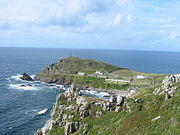
Cape Cornwall, England
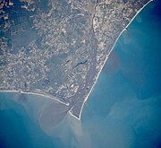
Satellite image of Cape Fear, North Carolina

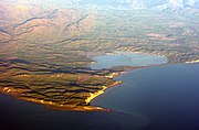
Cape MacLear, Malawi
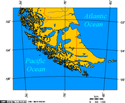
Map depicting Cape Horn at the southernmost portion of South America

Photograph of Cabo Mayor in Santander, Spain
Photograph of Cape Cambell, New Zealand, at sunrise


See also[]
- Extreme points of Africa
- Extreme points of Asia
- Extreme points of Europe
- Extreme points of North America
- Extreme points of South America
References[]
- ^ Whittow, John (1984). Dictionary of Physical Geography. London: Penguin, 1984, p. 80. ISBN 0-14-051094-X.
External links[]
| Wikimedia Commons has media related to Capes (geography). |


| Authority control: National libraries |
|---|
Categories:
- Coastal geography
- Headlands
- Coastal and oceanic landforms
- Oceanographical terminology