Ras Doumeira
This article needs additional citations for verification. (March 2018) |
| Ras Doumeira | |
|---|---|
| Raas Dumeera ራስ ዱሜራ | |
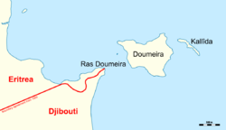 Map of Ras Doumeira with the de facto border | |
| Location | Djibouti–Eritrea border |
| Coordinates | 12°42′40″N 43°8′0″E / 12.71111°N 43.13333°ECoordinates: 12°42′40″N 43°8′0″E / 12.71111°N 43.13333°E |

Ras Doumeira (Cape Doumeira) (Somali: Raas Dumeera, Tigrinya: ራስ ዱሜራ) is a geographic cape that extends into the Red Sea, towards the Doumeira Islands. The area is shared by Djibouti and Eritrea, and was the subject of a 2008 border dispute between the two countries.[1]
References[]
- ^ "US condemns Eritrea 'aggression'". 12 June 2008. Retrieved 15 June 2008.
Categories:
- Geology of Djibouti
- Geology of Eritrea
- Peninsulas of Eritrea